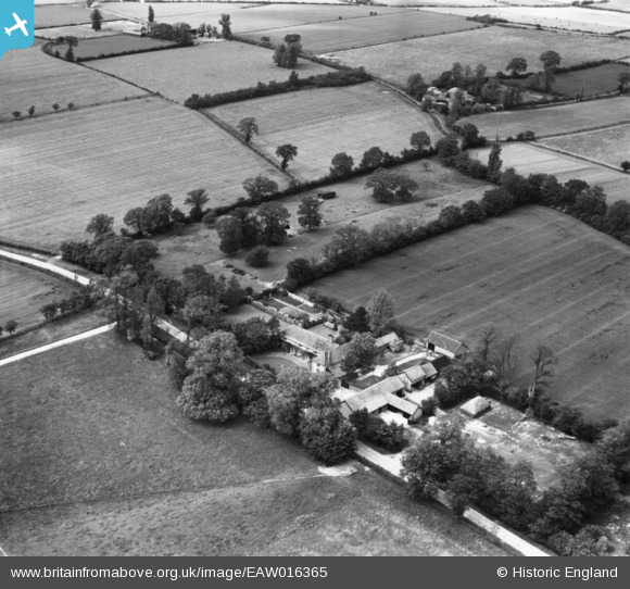
EAW016365 ENGLAND (1948). Cranley Manor, Cranley, 1948. This image has been produced from a print.
© Copyright OpenStreetMap contributors and licensed by the OpenStreetMap Foundation. 2025. Cartography is licensed as CC BY-SA.
Nearby Images (14)
Details
| Title | [EAW016365] Cranley Manor, Cranley, 1948. This image has been produced from a print. |
| Reference | EAW016365 |
| Date | 8-June-1948 |
| Link | |
| Place name | CRANLEY |
| Parish | EYE |
| District | |
| Country | ENGLAND |
| Easting / Northing | 616387, 272755 |
| Longitude / Latitude | 1.1746786210479, 52.309804464224 |
| National Grid Reference | TM164728 |
Pins
Be the first to add a comment to this image!


![[EAW016365] Cranley Manor, Cranley, 1948. This image has been produced from a print.](http://britainfromabove.org.uk/sites/all/libraries/aerofilms-images/public/100x100/EAW/016/EAW016365.jpg)
![[EAW016368] Cranley Manor, Cranley, 1948. This image has been produced from a print.](http://britainfromabove.org.uk/sites/all/libraries/aerofilms-images/public/100x100/EAW/016/EAW016368.jpg)
![[EAW016363] Cranley Manor, Cranley, from the north-west, 1948. This image has been produced from a print.](http://britainfromabove.org.uk/sites/all/libraries/aerofilms-images/public/100x100/EAW/016/EAW016363.jpg)
![[EAW016364] Cranley Manor, Cranley, 1948. This image has been produced from a print.](http://britainfromabove.org.uk/sites/all/libraries/aerofilms-images/public/100x100/EAW/016/EAW016364.jpg)
![[EAW016367] Cranley Manor, Cranley, 1948. This image has been produced from a print.](http://britainfromabove.org.uk/sites/all/libraries/aerofilms-images/public/100x100/EAW/016/EAW016367.jpg)
![[EAW016366] Cranley Manor, Cranley, 1948. This image has been produced from a print.](http://britainfromabove.org.uk/sites/all/libraries/aerofilms-images/public/100x100/EAW/016/EAW016366.jpg)
![[EAW051568] Cranley Manor, Eye, 1953. This image was marked by Aerofilms Ltd for photo editing.](http://britainfromabove.org.uk/sites/all/libraries/aerofilms-images/public/100x100/EAW/051/EAW051568.jpg)
![[EAW051569] Cranley Manor, Eye, 1953. This image was marked by Aerofilms Ltd for photo editing.](http://britainfromabove.org.uk/sites/all/libraries/aerofilms-images/public/100x100/EAW/051/EAW051569.jpg)
![[EAW051571] Cranley Manor, Eye, 1953. This image was marked by Aerofilms Ltd for photo editing.](http://britainfromabove.org.uk/sites/all/libraries/aerofilms-images/public/100x100/EAW/051/EAW051571.jpg)
![[EAW051570] Cranley Manor, Eye, 1953. This image was marked by Aerofilms Ltd for photo editing.](http://britainfromabove.org.uk/sites/all/libraries/aerofilms-images/public/100x100/EAW/051/EAW051570.jpg)
![[EAW051572] Cranley Manor, Eye, 1953. This image was marked by Aerofilms Ltd for photo editing.](http://britainfromabove.org.uk/sites/all/libraries/aerofilms-images/public/100x100/EAW/051/EAW051572.jpg)
![[EAW051573] Cranley Manor, Eye, 1953. This image was marked by Aerofilms Ltd for photo editing.](http://britainfromabove.org.uk/sites/all/libraries/aerofilms-images/public/100x100/EAW/051/EAW051573.jpg)
![[EAW051574] Cranley Manor, Eye, 1953. This image was marked by Aerofilms Ltd for photo editing.](http://britainfromabove.org.uk/sites/all/libraries/aerofilms-images/public/100x100/EAW/051/EAW051574.jpg)
![[EAW051575] Cranley Manor, Eye, 1953. This image was marked by Aerofilms Ltd for photo editing.](http://britainfromabove.org.uk/sites/all/libraries/aerofilms-images/public/100x100/EAW/051/EAW051575.jpg)