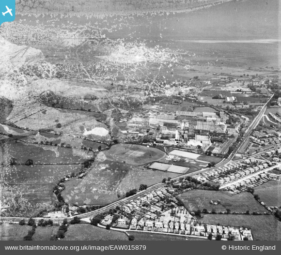
EAW015879 ENGLAND (1948). Chester Road and the British Insulated Callender's Cable Works, Helsby, 1948. This image has been produced from a damaged negative.
© Copyright OpenStreetMap contributors and licensed by the OpenStreetMap Foundation. 2025. Cartography is licensed as CC BY-SA.
Nearby Images (38)
Details
| Title | [EAW015879] Chester Road and the British Insulated Callender's Cable Works, Helsby, 1948. This image has been produced from a damaged negative. |
| Reference | EAW015879 |
| Date | 20-May-1948 |
| Link | |
| Place name | HELSBY |
| Parish | HELSBY |
| District | |
| Country | ENGLAND |
| Easting / Northing | 348275, 374749 |
| Longitude / Latitude | -2.7756182638072, 53.266932160865 |
| National Grid Reference | SJ483747 |


![[EAW015879] Chester Road and the British Insulated Callender's Cable Works, Helsby, 1948. This image has been produced from a damaged negative.](http://britainfromabove.org.uk/sites/all/libraries/aerofilms-images/public/100x100/EAW/015/EAW015879.jpg)
![[EPW057910] British Insulated Cable Works, Helsby, 1938. This image has been produced from a damaged negative.](http://britainfromabove.org.uk/sites/all/libraries/aerofilms-images/public/100x100/EPW/057/EPW057910.jpg)
![[EPW062724] British Insulated Cable Works, Helsby, 1939. This image was marked by Aerofilms Ltd for photo editing.](http://britainfromabove.org.uk/sites/all/libraries/aerofilms-images/public/100x100/EPW/062/EPW062724.jpg)
![[EPW060300] British Insulated Cable Works, Helsby, 1938](http://britainfromabove.org.uk/sites/all/libraries/aerofilms-images/public/100x100/EPW/060/EPW060300.jpg)
![[EPW060294] British Insulated Cable Works, Helsby, 1938](http://britainfromabove.org.uk/sites/all/libraries/aerofilms-images/public/100x100/EPW/060/EPW060294.jpg)
![[EPW060295] British Insulated Cable Works, Helsby, 1938](http://britainfromabove.org.uk/sites/all/libraries/aerofilms-images/public/100x100/EPW/060/EPW060295.jpg)
![[EPW060297] British Insulated Cable Works, Helsby, 1938](http://britainfromabove.org.uk/sites/all/libraries/aerofilms-images/public/100x100/EPW/060/EPW060297.jpg)
![[EPW062727] British Insulated Cable Works and environs, Helsby, 1939](http://britainfromabove.org.uk/sites/all/libraries/aerofilms-images/public/100x100/EPW/062/EPW062727.jpg)
![[EPW060299] British Insulated Cable Works, Helsby, 1938](http://britainfromabove.org.uk/sites/all/libraries/aerofilms-images/public/100x100/EPW/060/EPW060299.jpg)
![[EPW062722] British Insulated Cable Works and environs, Helsby, 1939](http://britainfromabove.org.uk/sites/all/libraries/aerofilms-images/public/100x100/EPW/062/EPW062722.jpg)
![[EPW057913] British Insulated Cable Works, Helsby, 1938](http://britainfromabove.org.uk/sites/all/libraries/aerofilms-images/public/100x100/EPW/057/EPW057913.jpg)
![[EAW015880] Chester Road and the British Insulated Callender's Cable Works (site of), Helsby, 1948. This image has been produced from a damaged negative.](http://britainfromabove.org.uk/sites/all/libraries/aerofilms-images/public/100x100/EAW/015/EAW015880.jpg)
![[EAW021976] British Insulated Callender's Cables Works and environs, Helsby, from the north-west, 1949](http://britainfromabove.org.uk/sites/all/libraries/aerofilms-images/public/100x100/EAW/021/EAW021976.jpg)
![[EAW015878] Chester Road and the British Insulated Callender's Cable Works, Helsby, 1948. This image has been produced from a print marked by Aerofilms Ltd for photo editing.](http://britainfromabove.org.uk/sites/all/libraries/aerofilms-images/public/100x100/EAW/015/EAW015878.jpg)
![[EPW062726] British Insulated Cable Works, Helsby, 1939](http://britainfromabove.org.uk/sites/all/libraries/aerofilms-images/public/100x100/EPW/062/EPW062726.jpg)
![[EPW057907] British Insulated Cable Works, Helsby, from the east, 1938](http://britainfromabove.org.uk/sites/all/libraries/aerofilms-images/public/100x100/EPW/057/EPW057907.jpg)
![[EPW062725] British Insulated Cable Works and environs, Helsby, 1939](http://britainfromabove.org.uk/sites/all/libraries/aerofilms-images/public/100x100/EPW/062/EPW062725.jpg)
![[EAW021977] British Insulated Callender's Cables Works, Helsby, 1949](http://britainfromabove.org.uk/sites/all/libraries/aerofilms-images/public/100x100/EAW/021/EAW021977.jpg)
![[EPW057908] British Insulated Cable Works, Helsby, 1938](http://britainfromabove.org.uk/sites/all/libraries/aerofilms-images/public/100x100/EPW/057/EPW057908.jpg)
![[EPW060291] British Insulated Cable Works, Helsby, 1938](http://britainfromabove.org.uk/sites/all/libraries/aerofilms-images/public/100x100/EPW/060/EPW060291.jpg)
![[EPW060293] British Insulated Cable Works, Helsby, 1938](http://britainfromabove.org.uk/sites/all/libraries/aerofilms-images/public/100x100/EPW/060/EPW060293.jpg)
![[EAW021975] British Insulated Callender's Cables Works, Chester Road and environs, Helsby, 1949. This image was marked by Aerofilms Ltd for photo editing.](http://britainfromabove.org.uk/sites/all/libraries/aerofilms-images/public/100x100/EAW/021/EAW021975.jpg)
![[EPW060292] British Insulated Cable Works, Helsby, 1938](http://britainfromabove.org.uk/sites/all/libraries/aerofilms-images/public/100x100/EPW/060/EPW060292.jpg)
![[EPW060290] British Insulated Cable Works, Helsby, 1938](http://britainfromabove.org.uk/sites/all/libraries/aerofilms-images/public/100x100/EPW/060/EPW060290.jpg)
![[EPW060296] British Insulated Cable Works, Helsby, 1938](http://britainfromabove.org.uk/sites/all/libraries/aerofilms-images/public/100x100/EPW/060/EPW060296.jpg)
![[EPW036904] British Insulated Cables Ltd, Helsby, 1931](http://britainfromabove.org.uk/sites/all/libraries/aerofilms-images/public/100x100/EPW/036/EPW036904.jpg)
![[EPW036903] British Insulated Cables Ltd, Helsby, 1931](http://britainfromabove.org.uk/sites/all/libraries/aerofilms-images/public/100x100/EPW/036/EPW036903.jpg)
![[EPW062723] British Insulated Cable Works, Helsby, 1939. This image was marked by Aerofilms Ltd for photo editing.](http://britainfromabove.org.uk/sites/all/libraries/aerofilms-images/public/100x100/EPW/062/EPW062723.jpg)
![[EAW021973] British Insulated Callender's Cables Works and environs, Helsby, 1949. This image was marked by Aerofilms Ltd for photo editing.](http://britainfromabove.org.uk/sites/all/libraries/aerofilms-images/public/100x100/EAW/021/EAW021973.jpg)
![[EPW036905] British Insulated Cables Ltd, Helsby, 1931](http://britainfromabove.org.uk/sites/all/libraries/aerofilms-images/public/100x100/EPW/036/EPW036905.jpg)
![[EPW036906] British Insulated Cables Ltd, Helsby, 1931](http://britainfromabove.org.uk/sites/all/libraries/aerofilms-images/public/100x100/EPW/036/EPW036906.jpg)
![[EAW021974] British Insulated Callender's Cables Works, Chester Road and environs, Helsby, 1949. This image was marked by Aerofilms Ltd for photo editing.](http://britainfromabove.org.uk/sites/all/libraries/aerofilms-images/public/100x100/EAW/021/EAW021974.jpg)
![[EPW060298] British Insulated Cable Works, Helsby, 1938](http://britainfromabove.org.uk/sites/all/libraries/aerofilms-images/public/100x100/EPW/060/EPW060298.jpg)
![[EPW029587] British Insulated Cable Works, Helsby, 1929](http://britainfromabove.org.uk/sites/all/libraries/aerofilms-images/public/100x100/EPW/029/EPW029587.jpg)
![[EAW021979] British Insulated Callender's Cables Works, Chester Road and environs, Helsby, from the north-east, 1949](http://britainfromabove.org.uk/sites/all/libraries/aerofilms-images/public/100x100/EAW/021/EAW021979.jpg)
![[EAW021978] British Insulated Callender's Cables Works, Helsby, from the east, 1949](http://britainfromabove.org.uk/sites/all/libraries/aerofilms-images/public/100x100/EAW/021/EAW021978.jpg)
![[EAW021980] British Insulated Callender's Cables Works, Helsby, from the south, 1949. This image was marked by Aerofilms Ltd for photo editing.](http://britainfromabove.org.uk/sites/all/libraries/aerofilms-images/public/100x100/EAW/021/EAW021980.jpg)
![[EPW060301] British Insulated Cable Works, Helsby, 1938](http://britainfromabove.org.uk/sites/all/libraries/aerofilms-images/public/100x100/EPW/060/EPW060301.jpg)

