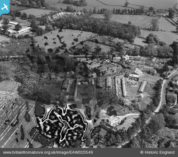
EAW015549 ENGLAND (1948). The Hale Laundry Ltd, Hale, 1948. This image has been produced from a damaged negative.
© Copyright OpenStreetMap contributors and licensed by the OpenStreetMap Foundation. 2026. Cartography is licensed as CC BY-SA.
Nearby Images (13)
Details
| Title | [EAW015549] The Hale Laundry Ltd, Hale, 1948. This image has been produced from a damaged negative. |
| Reference | EAW015549 |
| Date | 14-May-1948 |
| Link | |
| Place name | HALE |
| Parish | FARNHAM |
| District | |
| Country | ENGLAND |
| Easting / Northing | 484886, 148580 |
| Longitude / Latitude | -0.7841283116542, 51.229572997423 |
| National Grid Reference | SU849486 |
Pins
Be the first to add a comment to this image!


![[EAW015549] The Hale Laundry Ltd, Hale, 1948. This image has been produced from a damaged negative.](http://britainfromabove.org.uk/sites/all/libraries/aerofilms-images/public/100x100/EAW/015/EAW015549.jpg)
![[EAW015550] The Hale Laundry Ltd, Hale, 1948. This image has been produced from a damaged negative.](http://britainfromabove.org.uk/sites/all/libraries/aerofilms-images/public/100x100/EAW/015/EAW015550.jpg)
![[EAW015547] The Hale Laundry Ltd, Hale, from the south-west, 1948. This image has been produced from a print.](http://britainfromabove.org.uk/sites/all/libraries/aerofilms-images/public/100x100/EAW/015/EAW015547.jpg)
![[EAW015548] The Hale Laundry Ltd, Hale, 1948. This image has been produced from a print.](http://britainfromabove.org.uk/sites/all/libraries/aerofilms-images/public/100x100/EAW/015/EAW015548.jpg)
![[EAW015551] The Hale Laundry Ltd and environs, Hale, 1948. This image has been produced from a damaged negative.](http://britainfromabove.org.uk/sites/all/libraries/aerofilms-images/public/100x100/EAW/015/EAW015551.jpg)
![[EAW015555] The Hale Laundry Ltd and its drying grounds, Hale, 1948. This image has been produced from a print marked by Aerofilms Ltd for photo editing.](http://britainfromabove.org.uk/sites/all/libraries/aerofilms-images/public/100x100/EAW/015/EAW015555.jpg)
![[EAW015554] The Hale Laundry Ltd and its drying grounds, Hale, 1948. This image has been produced from a print marked by Aerofilms Ltd for photo editing.](http://britainfromabove.org.uk/sites/all/libraries/aerofilms-images/public/100x100/EAW/015/EAW015554.jpg)
![[EAW015552] The Hale Laundry Ltd and its drying grounds, Hale, 1948. This image has been produced from a print.](http://britainfromabove.org.uk/sites/all/libraries/aerofilms-images/public/100x100/EAW/015/EAW015552.jpg)
![[EAW022445] Hale Place and Hale Laundry off Farnborough Road, Farnham, from the south-east, 1949. This image was marked by Aerofilms Ltd for photo editing.](http://britainfromabove.org.uk/sites/all/libraries/aerofilms-images/public/100x100/EAW/022/EAW022445.jpg)
![[EAW015553] The Hale Laundry Ltd and its drying grounds, Hale, 1948. This image has been produced from a print marked by Aerofilms Ltd for photo editing.](http://britainfromabove.org.uk/sites/all/libraries/aerofilms-images/public/100x100/EAW/015/EAW015553.jpg)
![[EAW022447] Farnborough Road, Upper Hale Road and Monkton Lane, Farnham, 1949](http://britainfromabove.org.uk/sites/all/libraries/aerofilms-images/public/100x100/EAW/022/EAW022447.jpg)
![[EAW022446] Farnborough Road, Upper Hale Road and environs, Farnham, 1949. This image has been produced from a print.](http://britainfromabove.org.uk/sites/all/libraries/aerofilms-images/public/100x100/EAW/022/EAW022446.jpg)
![[EAW015537] Blankets drying in a field next to the Hale Laundry Ltd, Hale, 1948](http://britainfromabove.org.uk/sites/all/libraries/aerofilms-images/public/100x100/EAW/015/EAW015537.jpg)