
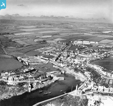
EAW015146 ENGLAND (1948). The Harbour, Inner Harbour and the town, Porthleven, from the south, 1948. This image has been produced from a print.

© Copyright OpenStreetMap contributors and licensed by the OpenStreetMap Foundation. 2026. Cartography is licensed as CC BY-SA.
Nearby Images (3)
EAW015146

EPW021766

EPW021765

Details
| Title | [EAW015146] The Harbour, Inner Harbour and the town, Porthleven, from the south, 1948. This image has been produced from a print. |
| Reference | EAW015146 |
| Date | 29-April-1948 |
| Link | |
| Place name | PORTHLEVEN |
| Parish | PORTHLEVEN |
| District | |
| Country | ENGLAND |
| Easting / Northing | 162844, 25726 |
| Longitude / Latitude | -5.3155296146069, 50.083606775088 |
| National Grid Reference | SW628257 |
Pins

Matt Aldred edob.mattaldred.com |
Sunday 29th of November 2020 08:41:12 PM | |
|
Matt Aldred edob.mattaldred.com |
Sunday 29th of November 2020 08:40:18 PM | |
|
Matt Aldred edob.mattaldred.com |
Sunday 29th of November 2020 08:39:25 PM | |

CornwallPhil |
Saturday 6th of September 2014 09:22:46 PM | |
|
CornwallPhil |
Saturday 6th of September 2014 09:18:41 PM | |
|
CornwallPhil |
Saturday 6th of September 2014 09:17:20 PM |
User Comment Contributions
Type 24 pillbox |
CornwallPhil |
Saturday 6th of September 2014 09:24:31 PM |