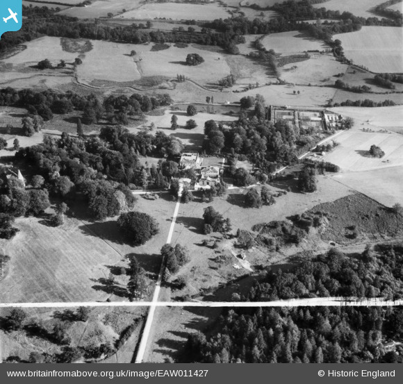
EAW011427 ENGLAND (1947). Buxted Park and St Margaret's Church, Buxted, 1947. This image was marked by Aerofilms Ltd for photo editing.
© Copyright OpenStreetMap contributors and licensed by the OpenStreetMap Foundation. 2026. Cartography is licensed as CC BY-SA.
Nearby Images (11)
Details
| Title | [EAW011427] Buxted Park and St Margaret's Church, Buxted, 1947. This image was marked by Aerofilms Ltd for photo editing. |
| Reference | EAW011427 |
| Date | 1-October-1947 |
| Link | |
| Place name | BUXTED |
| Parish | BUXTED |
| District | |
| Country | ENGLAND |
| Easting / Northing | 548468, 122822 |
| Longitude / Latitude | 0.11546928660282, 50.98508841527 |
| National Grid Reference | TQ485228 |
Pins
Be the first to add a comment to this image!


![[EAW011427] Buxted Park and St Margaret's Church, Buxted, 1947. This image was marked by Aerofilms Ltd for photo editing.](http://britainfromabove.org.uk/sites/all/libraries/aerofilms-images/public/100x100/EAW/011/EAW011427.jpg)
![[EAW011431] Buxted Park, Buxted, 1947](http://britainfromabove.org.uk/sites/all/libraries/aerofilms-images/public/100x100/EAW/011/EAW011431.jpg)
![[EAW011432] Buxted Park, Buxted, 1947](http://britainfromabove.org.uk/sites/all/libraries/aerofilms-images/public/100x100/EAW/011/EAW011432.jpg)
![[EAW011430] Buxted Park, Buxted, 1947](http://britainfromabove.org.uk/sites/all/libraries/aerofilms-images/public/100x100/EAW/011/EAW011430.jpg)
![[EAW011433] Buxted Park, Buxted, 1947](http://britainfromabove.org.uk/sites/all/libraries/aerofilms-images/public/100x100/EAW/011/EAW011433.jpg)
![[EAW011425] Buxted Park and St Margaret's Church, Buxted, 1947](http://britainfromabove.org.uk/sites/all/libraries/aerofilms-images/public/100x100/EAW/011/EAW011425.jpg)
![[EAW011426] Buxted Park and St Margaret's Church, Buxted, 1947](http://britainfromabove.org.uk/sites/all/libraries/aerofilms-images/public/100x100/EAW/011/EAW011426.jpg)
![[EAW011428] Buxted Park, Buxted, 1947. This image was marked by Aerofilms Ltd for photo editing.](http://britainfromabove.org.uk/sites/all/libraries/aerofilms-images/public/100x100/EAW/011/EAW011428.jpg)
![[EAW011429] Buxted Park, Buxted, 1947. This image was marked by Aerofilms Ltd for photo editing.](http://britainfromabove.org.uk/sites/all/libraries/aerofilms-images/public/100x100/EAW/011/EAW011429.jpg)
![[EAW011423] Buxted Park, Buxted, 1947](http://britainfromabove.org.uk/sites/all/libraries/aerofilms-images/public/100x100/EAW/011/EAW011423.jpg)
![[EAW011424] Buxted Park, Buxted, 1947. This image was marked by Aerofilms Ltd for photo editing.](http://britainfromabove.org.uk/sites/all/libraries/aerofilms-images/public/100x100/EAW/011/EAW011424.jpg)