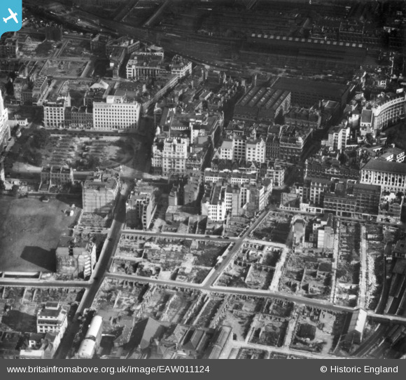
EAW011124 ENGLAND (1947). Cleared sites around Ropemaker Street following bomb damage, St Luke's, 1947. This image has been produced from a print.
    © Copyright OpenStreetMap contributors and licensed by the OpenStreetMap Foundation. 2025. Cartography is licensed as CC BY-SA.
  
Nearby Images (8)
Details
| Title | [EAW011124] Cleared sites around Ropemaker Street following bomb damage, St Luke's, 1947. This image has been produced from a print. | 
| Reference | EAW011124 | 
| Date | 30-October-1947 | 
| Link | |
| Place name | ST LUKE'S | 
| Parish | |
| District | |
| Country | ENGLAND | 
| Easting / Northing | 532765, 181846 | 
| Longitude / Latitude | -0.086233406392081, 51.51942803493 | 
| National Grid Reference | TQ328818 | 
Pins
|  Ropemaker Street |   brianbeckett | Saturday 16th of May 2020 08:37:59 AM | 
|  Broad Street Station |   S00Z | Thursday 16th of March 2017 04:05:49 PM | 
|  Finsbury Circus |   S00Z | Thursday 16th of March 2017 04:05:06 PM | 
|  Finsbury Square, EC2 |   billyfern | Friday 3rd of October 2014 06:56:49 PM | 
|  Bunhill Row, EC1 |   billyfern | Friday 3rd of October 2014 06:56:10 PM | 
|  Chiswell Street, EC1 |   billyfern | Friday 3rd of October 2014 06:55:53 PM | 
 
             
  ![[EAW011124] Cleared sites around Ropemaker Street following bomb damage, St Luke's, 1947. This image has been produced from a print.](http://britainfromabove.org.uk/sites/all/libraries/aerofilms-images/public/100x100/EAW/011/EAW011124.jpg) 
  
                                          ![[EPW053665] Finsbury Circus and Finsbury Square, Finsbury, 1937](http://britainfromabove.org.uk/sites/all/libraries/aerofilms-images/public/100x100/EPW/053/EPW053665.jpg) 
 ![[EPW053666] Finsbury Circus and Finsbury Square, Finsbury, 1937](http://britainfromabove.org.uk/sites/all/libraries/aerofilms-images/public/100x100/EPW/053/EPW053666.jpg) 
 ![[EAW000514] Bomb damage and clearance around Moorgate Street Station, the Artillery Ground and environs, London, 1946](http://britainfromabove.org.uk/sites/all/libraries/aerofilms-images/public/100x100/EAW/000/EAW000514.jpg) 
 ![[EAW011200] The New Artillery Ground and surrounding cleared sites following bomb damage, St Luke's, 1947](http://britainfromabove.org.uk/sites/all/libraries/aerofilms-images/public/100x100/EAW/011/EAW011200.jpg) 
 ![[EAW011199] Wilson Street, Finsbury Square and environs, St Luke's, 1947](http://britainfromabove.org.uk/sites/all/libraries/aerofilms-images/public/100x100/EAW/011/EAW011199.jpg) 
 ![[EAW011123] The New Artillery Ground and surrounding cleared sites following bomb damage, St Luke's, 1947. This image has been produced from a print.](http://britainfromabove.org.uk/sites/all/libraries/aerofilms-images/public/100x100/EAW/011/EAW011123.jpg) 
 ![[EAW011125] Finsbury Circus and cleared sites around Moorgate Street Station following bomb damage, London, 1947. This image has been produced from a print.](http://britainfromabove.org.uk/sites/all/libraries/aerofilms-images/public/100x100/EAW/011/EAW011125.jpg)