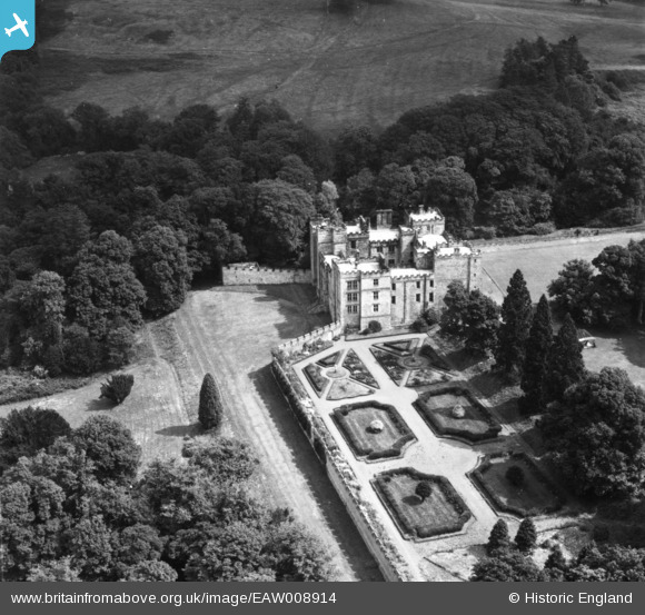
EAW008914 ENGLAND (1947). Chillingham Castle, Chillingham, 1947. This image has been produced from a print.
© Copyright OpenStreetMap contributors and licensed by the OpenStreetMap Foundation. 2025. Cartography is licensed as CC BY-SA.
Nearby Images (18)
Details
| Title | [EAW008914] Chillingham Castle, Chillingham, 1947. This image has been produced from a print. |
| Reference | EAW008914 |
| Date | 9-August-1947 |
| Link | |
| Place name | CHILLINGHAM |
| Parish | CHILLINGHAM |
| District | |
| Country | ENGLAND |
| Easting / Northing | 406133, 625812 |
| Longitude / Latitude | -1.9028402683706, 55.526000075632 |
| National Grid Reference | NU061258 |
Pins
Be the first to add a comment to this image!


![[EAW008914] Chillingham Castle, Chillingham, 1947. This image has been produced from a print.](http://britainfromabove.org.uk/sites/all/libraries/aerofilms-images/public/100x100/EAW/008/EAW008914.jpg)
![[EAW008918] Chillingham Castle, Chillingham, 1947. This image has been produced from a print.](http://britainfromabove.org.uk/sites/all/libraries/aerofilms-images/public/100x100/EAW/008/EAW008918.jpg)
![[EAW006084] Chillingham Castle and gardens, Chillingham, 1947](http://britainfromabove.org.uk/sites/all/libraries/aerofilms-images/public/100x100/EAW/006/EAW006084.jpg)
![[EAW007844] Chillingham Castle, Chillingham, 1947](http://britainfromabove.org.uk/sites/all/libraries/aerofilms-images/public/100x100/EAW/007/EAW007844.jpg)
![[EAW008919] Chillingham Castle, Chillingham, 1947](http://britainfromabove.org.uk/sites/all/libraries/aerofilms-images/public/100x100/EAW/008/EAW008919.jpg)
![[EAW007845] Chillingham Castle, Chillingham, 1947](http://britainfromabove.org.uk/sites/all/libraries/aerofilms-images/public/100x100/EAW/007/EAW007845.jpg)
![[EAW006083] Chillingham Castle and gardens, Chillingham, 1947](http://britainfromabove.org.uk/sites/all/libraries/aerofilms-images/public/100x100/EAW/006/EAW006083.jpg)
![[EAW007841] Chillingham Castle, Chillingham, 1947](http://britainfromabove.org.uk/sites/all/libraries/aerofilms-images/public/100x100/EAW/007/EAW007841.jpg)
![[EAW006082] Chillingham Castle and gardens, Chillingham, 1947](http://britainfromabove.org.uk/sites/all/libraries/aerofilms-images/public/100x100/EAW/006/EAW006082.jpg)
![[EAW007842] Chillingham Castle, Chillingham, 1947](http://britainfromabove.org.uk/sites/all/libraries/aerofilms-images/public/100x100/EAW/007/EAW007842.jpg)
![[EAW007847] Chillingham Castle, Chillingham, 1947](http://britainfromabove.org.uk/sites/all/libraries/aerofilms-images/public/100x100/EAW/007/EAW007847.jpg)
![[EAW008917] Chillingham Castle, Chillingham, 1947. This image has been produced from a print.](http://britainfromabove.org.uk/sites/all/libraries/aerofilms-images/public/100x100/EAW/008/EAW008917.jpg)
![[EAW008915] Chillingham Castle, Chillingham, 1947](http://britainfromabove.org.uk/sites/all/libraries/aerofilms-images/public/100x100/EAW/008/EAW008915.jpg)
![[EAW008916] Chillingham Castle, Chillingham, 1947. This image has been produced from a print.](http://britainfromabove.org.uk/sites/all/libraries/aerofilms-images/public/100x100/EAW/008/EAW008916.jpg)
![[EAW007843] Chillingham Castle, Chillingham, 1947](http://britainfromabove.org.uk/sites/all/libraries/aerofilms-images/public/100x100/EAW/007/EAW007843.jpg)
![[EAW006085] Chillingham Castle and gardens, Chillingham, 1947](http://britainfromabove.org.uk/sites/all/libraries/aerofilms-images/public/100x100/EAW/006/EAW006085.jpg)
![[EAW006087] Chillingham Castle and gardens, Chillingham, 1947](http://britainfromabove.org.uk/sites/all/libraries/aerofilms-images/public/100x100/EAW/006/EAW006087.jpg)
![[EAW006086] Chillingham Castle and gardens, Chillingham, 1947](http://britainfromabove.org.uk/sites/all/libraries/aerofilms-images/public/100x100/EAW/006/EAW006086.jpg)