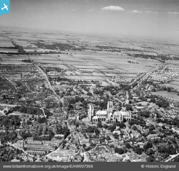
EAW007366 ENGLAND (1947). St Mary's Cathedral and the city centre, Lincoln, from the south, 1947
© Copyright OpenStreetMap contributors and licensed by the OpenStreetMap Foundation. 2026. Cartography is licensed as CC BY-SA.
Nearby Images (29)
Details
| Title | [EAW007366] St Mary's Cathedral and the city centre, Lincoln, from the south, 1947 |
| Reference | EAW007366 |
| Date | 24-June-1947 |
| Link | |
| Place name | LINCOLN |
| Parish | |
| District | |
| Country | ENGLAND |
| Easting / Northing | 497717, 371793 |
| Longitude / Latitude | -0.53582619343819, 53.233888138986 |
| National Grid Reference | SK977718 |
Pins

Bristol MW |
Wednesday 23rd of October 2019 06:16:36 AM | |

redmist |
Friday 17th of May 2019 09:13:10 PM | |

Shaun Martin |
Saturday 3rd of June 2017 11:05:45 AM | |

Shaun Martin |
Saturday 3rd of June 2017 11:04:34 AM | |

Ian |
Sunday 30th of November 2014 09:02:41 PM | |

Class31 |
Wednesday 15th of October 2014 03:36:14 PM | |

John Herridge |
Thursday 20th of February 2014 11:53:26 AM | |

John Herridge |
Thursday 20th of February 2014 11:46:25 AM |


![[EAW007366] St Mary's Cathedral and the city centre, Lincoln, from the south, 1947](http://britainfromabove.org.uk/sites/all/libraries/aerofilms-images/public/100x100/EAW/007/EAW007366.jpg)
![[EAW023933] Lincoln Cathedral, Lincoln, 1949. This image has been produced from a damaged negative.](http://britainfromabove.org.uk/sites/all/libraries/aerofilms-images/public/100x100/EAW/023/EAW023933.jpg)
![[EAW002781] St Mary's Cathedral and the city, Lincoln, 1946](http://britainfromabove.org.uk/sites/all/libraries/aerofilms-images/public/100x100/EAW/002/EAW002781.jpg)
![[EAW003316] The Cathedral Church of the Blessed Virgin Mary and the town, Lincoln, 1946](http://britainfromabove.org.uk/sites/all/libraries/aerofilms-images/public/100x100/EAW/003/EAW003316.jpg)
![[EAW015702] The city centre, Lincoln, 1948](http://britainfromabove.org.uk/sites/all/libraries/aerofilms-images/public/100x100/EAW/015/EAW015702.jpg)
![[EAW015728] The Cathedral Church of the Blessed Virgin Mary, Lincoln, 1948](http://britainfromabove.org.uk/sites/all/libraries/aerofilms-images/public/100x100/EAW/015/EAW015728.jpg)
![[EAW003315] The Cathedral Church of the Blessed Virgin Mary and the town, Lincoln, 1946](http://britainfromabove.org.uk/sites/all/libraries/aerofilms-images/public/100x100/EAW/003/EAW003315.jpg)
![[EPW041639] Lincoln Cathedral, Lincoln Castle and the city, Lincoln, 1933](http://britainfromabove.org.uk/sites/all/libraries/aerofilms-images/public/100x100/EPW/041/EPW041639.jpg)
![[EPW041645] Lincoln Cathedral, Lincoln, 1933](http://britainfromabove.org.uk/sites/all/libraries/aerofilms-images/public/100x100/EPW/041/EPW041645.jpg)
![[EAW015703] The city centre, Lincoln, 1948](http://britainfromabove.org.uk/sites/all/libraries/aerofilms-images/public/100x100/EAW/015/EAW015703.jpg)
![[EAW005040] The Cathedral Church of the Blessed Virgin Mary, Lincoln, 1947](http://britainfromabove.org.uk/sites/all/libraries/aerofilms-images/public/100x100/EAW/005/EAW005040.jpg)
![[EAW003313] The Cathedral Church of the Blessed Virgin Mary and the town, Lincoln, from the west, 1946](http://britainfromabove.org.uk/sites/all/libraries/aerofilms-images/public/100x100/EAW/003/EAW003313.jpg)
![[EAW023934] Lincoln Cathedral, Lincoln, 1949. This image has been produced from a damaged negative.](http://britainfromabove.org.uk/sites/all/libraries/aerofilms-images/public/100x100/EAW/023/EAW023934.jpg)
![[EAW003648] The Cathedral Church of the Blessed Virgin Mary and environs, Lincoln, 1947](http://britainfromabove.org.uk/sites/all/libraries/aerofilms-images/public/100x100/EAW/003/EAW003648.jpg)
![[EPW006627] St Mary's Cathedral, Lincoln, 1921](http://britainfromabove.org.uk/sites/all/libraries/aerofilms-images/public/100x100/EPW/006/EPW006627.jpg)
![[EAW023932] Lincoln Cathedral, Lincoln, 1949](http://britainfromabove.org.uk/sites/all/libraries/aerofilms-images/public/100x100/EAW/023/EAW023932.jpg)
![[EAW002782] St Mary's Cathedral and the city, Lincoln, 1946](http://britainfromabove.org.uk/sites/all/libraries/aerofilms-images/public/100x100/EAW/002/EAW002782.jpg)
![[EPW041643] Lincoln Cathedral, Lincoln, 1933](http://britainfromabove.org.uk/sites/all/libraries/aerofilms-images/public/100x100/EPW/041/EPW041643.jpg)
![[EAW003312] The Cathedral Church of the Blessed Virgin Mary, Lincoln, 1946](http://britainfromabove.org.uk/sites/all/libraries/aerofilms-images/public/100x100/EAW/003/EAW003312.jpg)
![[EAW005044] The Cathedral Church of the Blessed Virgin Mary and the city, Lincoln, 1947](http://britainfromabove.org.uk/sites/all/libraries/aerofilms-images/public/100x100/EAW/005/EAW005044.jpg)
![[EAW003314] The Cathedral Church of the Blessed Virgin Mary, the castle and the town, Lincoln, 1946. This image has been produced from a damaged negative.](http://britainfromabove.org.uk/sites/all/libraries/aerofilms-images/public/100x100/EAW/003/EAW003314.jpg)
![[EAW005046] Lincoln Castle, The Cathedral Church of the Blessed Virgin Mary and environs, Lincoln, 1947. This image has been produced from a print.](http://britainfromabove.org.uk/sites/all/libraries/aerofilms-images/public/100x100/EAW/005/EAW005046.jpg)
![[EAW015700] The city centre, Lincoln, 1948](http://britainfromabove.org.uk/sites/all/libraries/aerofilms-images/public/100x100/EAW/015/EAW015700.jpg)
![[EAW005041] Lincoln Castle, The Cathedral Church of the Blessed Virgin Mary and environs, Lincoln, 1947](http://britainfromabove.org.uk/sites/all/libraries/aerofilms-images/public/100x100/EAW/005/EAW005041.jpg)
![[EPW041644] Lincoln Cathedral and the city, Lincoln, 1933](http://britainfromabove.org.uk/sites/all/libraries/aerofilms-images/public/100x100/EPW/041/EPW041644.jpg)
![[EAW015729] The city centre, Lincoln, 1948](http://britainfromabove.org.uk/sites/all/libraries/aerofilms-images/public/100x100/EAW/015/EAW015729.jpg)
![[EAW005045] Lincoln Castle and environs, Lincoln, 1947. This image has been produced from a print.](http://britainfromabove.org.uk/sites/all/libraries/aerofilms-images/public/100x100/EAW/005/EAW005045.jpg)
![[EPW041646] Lincoln Cathedral, the Westgate Water Tower and West Common, Lincoln, from the east, 1933](http://britainfromabove.org.uk/sites/all/libraries/aerofilms-images/public/100x100/EPW/041/EPW041646.jpg)
![[EPW041641] Lincoln Castle and the Westgate Water Tower, Lincoln, 1933. This image has been produced from a damaged negative.](http://britainfromabove.org.uk/sites/all/libraries/aerofilms-images/public/100x100/EPW/041/EPW041641.jpg)