
EAW006435 ENGLAND (1947). Dudbridge Road and environs, Lightpill, 1947. This image was marked by Aerofilms Ltd for photo editing.

© Copyright OpenStreetMap contributors and licensed by the OpenStreetMap Foundation. 2026. Cartography is licensed as CC BY-SA.
Nearby Images (15)
EAW006435

EAW006431

EAW006427

EAW006429

EAW016112

EAW016111

EAW006432

EAW006433

EAW006430

EAW006425

EAW016114

EAW016115
, Lightpill, from the north-east, 1948. This image has been produced from a damaged negative.")
EAW016116

EAW016113

EAW016109

Details
| Title | [EAW006435] Dudbridge Road and environs, Lightpill, 1947. This image was marked by Aerofilms Ltd for photo editing. |
| Reference | EAW006435 |
| Date | 29-May-1947 |
| Link | |
| Place name | LIGHTPILL |
| Parish | RODBOROUGH |
| District | |
| Country | ENGLAND |
| Easting / Northing | 383842, 204142 |
| Longitude / Latitude | -2.2340109921677, 51.73529842479 |
| National Grid Reference | SO838041 |
Pins
User Comment Contributions
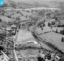
Shows the Stroud branch railway junction at Dudbridge |

cookie |
Wednesday 12th of February 2014 01:39:08 PM |