
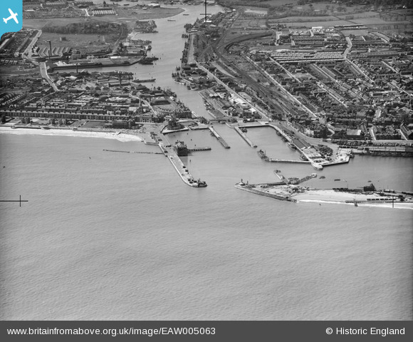
EAW005063 ENGLAND (1947). The Outer Harbour, Lowestoft, 1947
© Copyright OpenStreetMap contributors and licensed by the OpenStreetMap Foundation. 2026. Cartography is licensed as CC BY-SA.
Nearby Images (12)
EAW005063

EPW021252

EAW025476

EAW031906

EAW005064

EAW031907

EAW031909

EAW052979

EAR032727

EAW047639

EAW052978

EAW025475

Details
| Title | [EAW005063] The Outer Harbour, Lowestoft, 1947 |
| Reference | EAW005063 |
| Date | 11-May-1947 |
| Link | |
| Place name | LOWESTOFT |
| Parish | |
| District | |
| Country | ENGLAND |
| Easting / Northing | 655021, 292629 |
| Longitude / Latitude | 1.7553985591798, 52.47153629841 |
| National Grid Reference | TM550926 |
Pins

JUNGLEJIM |
Sunday 23rd of August 2020 04:15:57 PM | |
|
JUNGLEJIM |
Sunday 23rd of August 2020 04:13:27 PM | |
|
Eddy |
Wednesday 19th of August 2020 05:34:32 PM | |
|
Eddy |
Wednesday 19th of August 2020 05:30:54 PM | |
|
Eddy |
Wednesday 19th of August 2020 05:23:02 PM | |
|
Eddy |
Wednesday 19th of August 2020 05:20:52 PM | |
|
Eddy |
Wednesday 19th of August 2020 05:18:36 PM | |
|
Eddy |
Wednesday 19th of August 2020 05:17:25 PM | |
|
Eddy |
Wednesday 19th of August 2020 05:15:44 PM | |
|
Eddy |
Wednesday 19th of August 2020 05:15:07 PM | |
|
Eddy |
Wednesday 19th of August 2020 05:13:49 PM | |
|
Eddy |
Wednesday 19th of August 2020 05:12:46 PM | |
|
Eddy |
Wednesday 19th of August 2020 05:11:21 PM | |
|
Eddy |
Wednesday 19th of August 2020 05:10:06 PM | |
|
Eddy |
Wednesday 19th of August 2020 05:09:29 PM | |
|
Eddy |
Wednesday 19th of August 2020 05:08:37 PM |