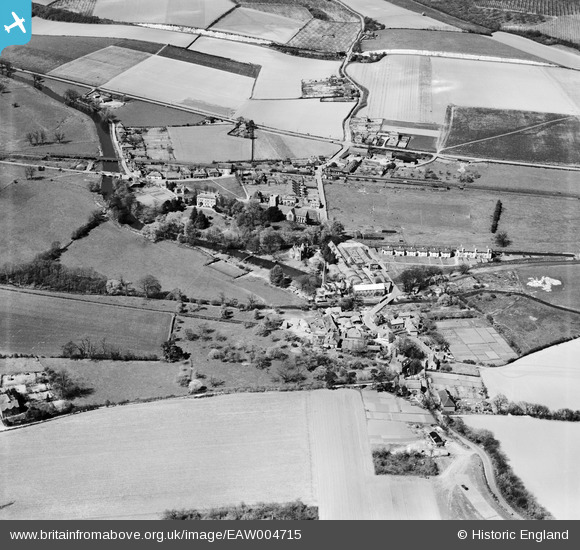
EAW004715 ENGLAND (1947). The village, Chartham, 1947
© Copyright OpenStreetMap contributors and licensed by the OpenStreetMap Foundation. 2026. Cartography is licensed as CC BY-SA.
Nearby Images (23)
Details
| Title | [EAW004715] The village, Chartham, 1947 |
| Reference | EAW004715 |
| Date | 26-April-1947 |
| Link | |
| Place name | CHARTHAM |
| Parish | CHARTHAM |
| District | |
| Country | ENGLAND |
| Easting / Northing | 610736, 154982 |
| Longitude / Latitude | 1.0203791356862, 51.254486129291 |
| National Grid Reference | TR107550 |
Pins

Sparky |
Sunday 2nd of July 2017 10:08:13 PM | |

Sparky |
Sunday 2nd of July 2017 10:07:07 PM | |

John Wass |
Friday 17th of April 2015 08:55:51 PM | |

cptpies |
Monday 8th of December 2014 08:57:13 AM |
User Comment Contributions

cptpies |
Monday 8th of December 2014 08:58:50 AM |


![[EAW004715] The village, Chartham, 1947](http://britainfromabove.org.uk/sites/all/libraries/aerofilms-images/public/100x100/EAW/004/EAW004715.jpg)
![[EAW014326] Chartham Paper Mill and environs, Chartham, 1948. This image has been produced from a damaged negative.](http://britainfromabove.org.uk/sites/all/libraries/aerofilms-images/public/100x100/EAW/014/EAW014326.jpg)
![[EAW014332] Chartham Paper Mill and environs, Chartham, 1948. This image has been produced from a damaged negative.](http://britainfromabove.org.uk/sites/all/libraries/aerofilms-images/public/100x100/EAW/014/EAW014332.jpg)
![[EAW014333] Chartham Paper Mill and environs, Chartham, 1948. This image has been produced from a damaged negative.](http://britainfromabove.org.uk/sites/all/libraries/aerofilms-images/public/100x100/EAW/014/EAW014333.jpg)
![[EAW014330] Chartham Paper Mill, Chartham, 1948. This image has been produced from a damaged negative.](http://britainfromabove.org.uk/sites/all/libraries/aerofilms-images/public/100x100/EAW/014/EAW014330.jpg)
![[EAW026264] Chartham Paper Mill, Chartham, from the south-west, 1949. This image has been produced from a print.](http://britainfromabove.org.uk/sites/all/libraries/aerofilms-images/public/100x100/EAW/026/EAW026264.jpg)
![[EAW026261] Chartham Paper Mill, Chartham, 1949. This image has been produced from a print marked by Aerofilms Ltd for photo editing.](http://britainfromabove.org.uk/sites/all/libraries/aerofilms-images/public/100x100/EAW/026/EAW026261.jpg)
![[EAW014329] Chartham Paper Mill, Chartham, 1948. This image was marked by Aerofilms Ltd for photo editing.](http://britainfromabove.org.uk/sites/all/libraries/aerofilms-images/public/100x100/EAW/014/EAW014329.jpg)
![[EAW014331] Chartham Paper Mill, Chartham, 1948. This image has been produced from a damaged negative.](http://britainfromabove.org.uk/sites/all/libraries/aerofilms-images/public/100x100/EAW/014/EAW014331.jpg)
![[EAW004718] The village, Chartham, 1947](http://britainfromabove.org.uk/sites/all/libraries/aerofilms-images/public/100x100/EAW/004/EAW004718.jpg)
![[EAW026258] Chartham Paper Mill, Chartham, 1949. This image was marked by Aerofilms Ltd for photo editing.](http://britainfromabove.org.uk/sites/all/libraries/aerofilms-images/public/100x100/EAW/026/EAW026258.jpg)
![[EAW026256] Chartham Paper Mill, Chartham, 1949. This image was marked by Aerofilms Ltd for photo editing.](http://britainfromabove.org.uk/sites/all/libraries/aerofilms-images/public/100x100/EAW/026/EAW026256.jpg)
![[EAW014327] Chartham Paper Mill, Chartham, 1948. This image has been produced from a damaged negative.](http://britainfromabove.org.uk/sites/all/libraries/aerofilms-images/public/100x100/EAW/014/EAW014327.jpg)
![[EAW026260] Chartham Paper Mill, Chartham, 1949](http://britainfromabove.org.uk/sites/all/libraries/aerofilms-images/public/100x100/EAW/026/EAW026260.jpg)
![[EAW014325] Chartham Paper Mill and environs, Chartham, 1948. This image was marked by Aerofilms Ltd for photo editing.](http://britainfromabove.org.uk/sites/all/libraries/aerofilms-images/public/100x100/EAW/014/EAW014325.jpg)
![[EAW014328] Chartham Paper Mill and environs, Chartham, 1948. This image was marked by Aerofilms Ltd for photo editing.](http://britainfromabove.org.uk/sites/all/libraries/aerofilms-images/public/100x100/EAW/014/EAW014328.jpg)
![[EAW026262] Chartham Paper Mill, Chartham, 1949. This image has been produced from a print marked by Aerofilms Ltd for photo editing.](http://britainfromabove.org.uk/sites/all/libraries/aerofilms-images/public/100x100/EAW/026/EAW026262.jpg)
![[EAW026257] Chartham Paper Mill and Mill Terrace, Chartham, 1949. This image was marked by Aerofilms Ltd for photo editing.](http://britainfromabove.org.uk/sites/all/libraries/aerofilms-images/public/100x100/EAW/026/EAW026257.jpg)
![[EAW026263] Chartham Paper Mill, Chartham, 1949. This image has been produced from a print marked by Aerofilms Ltd for photo editing.](http://britainfromabove.org.uk/sites/all/libraries/aerofilms-images/public/100x100/EAW/026/EAW026263.jpg)
![[EAW026259] Chartham Paper Mill and Mill Terrace, Chartham, 1949. This image was marked by Aerofilms Ltd for photo editing.](http://britainfromabove.org.uk/sites/all/libraries/aerofilms-images/public/100x100/EAW/026/EAW026259.jpg)
![[EAW004716] The village, Chartham, 1947](http://britainfromabove.org.uk/sites/all/libraries/aerofilms-images/public/100x100/EAW/004/EAW004716.jpg)
![[EAW004717] The village, Chartham, 1947](http://britainfromabove.org.uk/sites/all/libraries/aerofilms-images/public/100x100/EAW/004/EAW004717.jpg)
![[EPW038131] Rattington Street, Chartham, 1932](http://britainfromabove.org.uk/sites/all/libraries/aerofilms-images/public/100x100/EPW/038/EPW038131.jpg)
