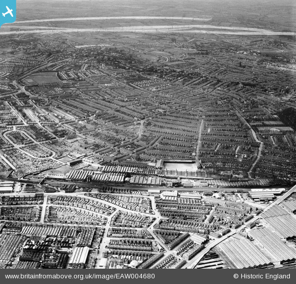
EAW004680 ENGLAND (1947). The city, Derby, from the south-east, 1947
© Copyright OpenStreetMap contributors and licensed by the OpenStreetMap Foundation. 2026. Cartography is licensed as CC BY-SA.
Nearby Images (35)
Details
| Title | [EAW004680] The city, Derby, from the south-east, 1947 |
| Reference | EAW004680 |
| Date | 22-April-1947 |
| Link | |
| Place name | DERBY |
| Parish | |
| District | |
| Country | ENGLAND |
| Easting / Northing | 436012, 334058 |
| Longitude / Latitude | -1.4645439393787, 52.902432331323 |
| National Grid Reference | SK360341 |


![[EAW004680] The city, Derby, from the south-east, 1947](http://britainfromabove.org.uk/sites/all/libraries/aerofilms-images/public/100x100/EAW/004/EAW004680.jpg)
![[EPW016993] Cotton Lane and environs, Derby, 1926. This image has been produced from a copy-negative.](http://britainfromabove.org.uk/sites/all/libraries/aerofilms-images/public/100x100/EPW/016/EPW016993.jpg)
![[EPW016991] Cotton Lane and environs, Derby, 1926. This image has been produced from a copy-negative.](http://britainfromabove.org.uk/sites/all/libraries/aerofilms-images/public/100x100/EPW/016/EPW016991.jpg)
![[EAW044385] Leys Malleable Castings Co Works, the Baseball Ground, Derby Carriage and Wagon Works and environs, Derby, 1952. This image was marked by Aerofilms Ltd for photo editing.](http://britainfromabove.org.uk/sites/all/libraries/aerofilms-images/public/100x100/EAW/044/EAW044385.jpg)
![[EPW020799] Leys Malleable Castings Co Works, Derby, from the south-east, 1928](http://britainfromabove.org.uk/sites/all/libraries/aerofilms-images/public/100x100/EPW/020/EPW020799.jpg)
![[EAW004679] The city, Derby, from the south-east, 1947](http://britainfromabove.org.uk/sites/all/libraries/aerofilms-images/public/100x100/EAW/004/EAW004679.jpg)
![[EAW002480] Leys Malleable Castings Co Works, The Baseball Ground and environs, Derby, 1946](http://britainfromabove.org.uk/sites/all/libraries/aerofilms-images/public/100x100/EAW/002/EAW002480.jpg)
![[EAW004677] The city, Derby, from the south-east, 1947. This image was marked by Aerofilms Ltd for photo editing.](http://britainfromabove.org.uk/sites/all/libraries/aerofilms-images/public/100x100/EAW/004/EAW004677.jpg)
![[EAW002479] Leys Malleable Castings Co Works, The Baseball Ground and environs, Derby, 1946](http://britainfromabove.org.uk/sites/all/libraries/aerofilms-images/public/100x100/EAW/002/EAW002479.jpg)
![[EAW013120] Works off Russell Street, Leys Malleable Castings Co Works and the Derby Carriage and Wagon Works, Osmaston, 1948](http://britainfromabove.org.uk/sites/all/libraries/aerofilms-images/public/100x100/EAW/013/EAW013120.jpg)
![[EAW004682] The city, Derby, from the south-east, 1947. This image was marked by Aerofilms Ltd for photo editing.](http://britainfromabove.org.uk/sites/all/libraries/aerofilms-images/public/100x100/EAW/004/EAW004682.jpg)
![[EPW016995] Ley's Malleable Castings Co Works and environs, Derby, 1926. This image has been produced from a copy-negative.](http://britainfromabove.org.uk/sites/all/libraries/aerofilms-images/public/100x100/EPW/016/EPW016995.jpg)
![[EAW013121] Works off Russell Street and the Derby Carriage and Wagon Works, Osmaston, 1948](http://britainfromabove.org.uk/sites/all/libraries/aerofilms-images/public/100x100/EAW/013/EAW013121.jpg)
![[EAW004681] The city, Derby, from the south-east, 1947](http://britainfromabove.org.uk/sites/all/libraries/aerofilms-images/public/100x100/EAW/004/EAW004681.jpg)
![[EPW046668] Ley's Malleable Castings Co Works and The Baseball Ground, Derby, 1935](http://britainfromabove.org.uk/sites/all/libraries/aerofilms-images/public/100x100/EPW/046/EPW046668.jpg)
![[EPW005809] Ley's Vulcan Iron Works and The Baseball Ground, Derby, 1921](http://britainfromabove.org.uk/sites/all/libraries/aerofilms-images/public/100x100/EPW/005/EPW005809.jpg)
![[EAW044382] Leys Malleable Castings Co Works and environs, Derby, 1952. This image was marked by Aerofilms Ltd for photo editing.](http://britainfromabove.org.uk/sites/all/libraries/aerofilms-images/public/100x100/EAW/044/EAW044382.jpg)
![[EPW005807] Ley's Vulcan Iron Works and The Baseball Ground, Derby, 1921](http://britainfromabove.org.uk/sites/all/libraries/aerofilms-images/public/100x100/EPW/005/EPW005807.jpg)
![[EAW013122] Works off Russell Street and the Derby Carriage and Wagon Works, Osmaston, 1948](http://britainfromabove.org.uk/sites/all/libraries/aerofilms-images/public/100x100/EAW/013/EAW013122.jpg)
![[EPW046667] Ley's Malleable Castings Co Works and The Baseball Ground, Derby, 1935](http://britainfromabove.org.uk/sites/all/libraries/aerofilms-images/public/100x100/EPW/046/EPW046667.jpg)
![[EPW046660] Ley's Malleable Castings Co Works and environs, Derby, from the south-east, 1935](http://britainfromabove.org.uk/sites/all/libraries/aerofilms-images/public/100x100/EPW/046/EPW046660.jpg)
![[EAW002476] Leys Malleable Castings Co Works, The Baseball Ground and environs, Derby, 1946](http://britainfromabove.org.uk/sites/all/libraries/aerofilms-images/public/100x100/EAW/002/EAW002476.jpg)
![[EAW002478] Leys Malleable Castings Co Works and The Baseball Ground, Derby, 1946](http://britainfromabove.org.uk/sites/all/libraries/aerofilms-images/public/100x100/EAW/002/EAW002478.jpg)
![[EPW046664] Ley's Malleable Castings Co Works and environs, Derby, 1935](http://britainfromabove.org.uk/sites/all/libraries/aerofilms-images/public/100x100/EPW/046/EPW046664.jpg)
![[EAW002481] Leys Malleable Castings Co Works, The Baseball Ground and environs, Derby, 1946](http://britainfromabove.org.uk/sites/all/libraries/aerofilms-images/public/100x100/EAW/002/EAW002481.jpg)
![[EAW002477] Leys Malleable Castings Co Works, The Baseball Ground and environs, Derby, 1946](http://britainfromabove.org.uk/sites/all/libraries/aerofilms-images/public/100x100/EAW/002/EAW002477.jpg)
![[EPW046661] Ley's Malleable Castings Co Works and environs, Derby, from the south-east, 1935](http://britainfromabove.org.uk/sites/all/libraries/aerofilms-images/public/100x100/EPW/046/EPW046661.jpg)
![[EAW013124] The Rolls Royce Drawing Offices on Elton Road, Leys Malleable Castings Co Works and environs, Osmaston, 1948](http://britainfromabove.org.uk/sites/all/libraries/aerofilms-images/public/100x100/EAW/013/EAW013124.jpg)
![[EPW020802] Leys Malleable Castings Co Works and the surrounding residential area, Derby, 1928. This image has been produced from a copy-negative.](http://britainfromabove.org.uk/sites/all/libraries/aerofilms-images/public/100x100/EPW/020/EPW020802.jpg)
![[EAW013110] Elton Road and environs including the Rolls Royce Nightingale Road Works and Leys Malleable Castings Co Works, Osmaston, 1948](http://britainfromabove.org.uk/sites/all/libraries/aerofilms-images/public/100x100/EAW/013/EAW013110.jpg)
![[EPW005810] Ley's Vulcan Iron Works and The Baseball Ground, Derby, 1921](http://britainfromabove.org.uk/sites/all/libraries/aerofilms-images/public/100x100/EPW/005/EPW005810.jpg)
![[EPW045453] Leys Malleable Castings Co Works, Derby, from the south, 1934](http://britainfromabove.org.uk/sites/all/libraries/aerofilms-images/public/100x100/EPW/045/EPW045453.jpg)
![[EAW044380] Leys Malleable Castings Co Works, the Baseball Ground and environs, Derby, 1952](http://britainfromabove.org.uk/sites/all/libraries/aerofilms-images/public/100x100/EAW/044/EAW044380.jpg)
![[EAW004678] The city, Derby, from the east, 1947. This image was marked by Aerofilms Ltd for photo editing.](http://britainfromabove.org.uk/sites/all/libraries/aerofilms-images/public/100x100/EAW/004/EAW004678.jpg)
![[EPW020798] Leys Malleable Castings Co Works, Derby, from the south-east, 1928](http://britainfromabove.org.uk/sites/all/libraries/aerofilms-images/public/100x100/EPW/020/EPW020798.jpg)
