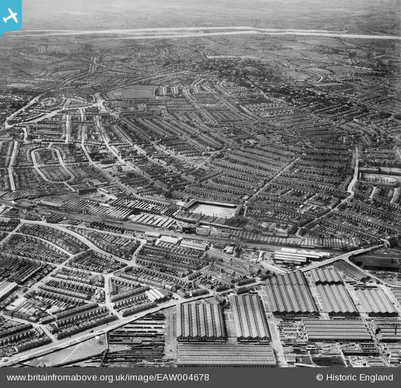
EAW004678 ENGLAND (1947). The city, Derby, from the east, 1947. This image was marked by Aerofilms Ltd for photo editing.
© Copyright OpenStreetMap contributors and licensed by the OpenStreetMap Foundation. 2026. Cartography is licensed as CC BY-SA.
Nearby Images (10)
Details
| Title | [EAW004678] The city, Derby, from the east, 1947. This image was marked by Aerofilms Ltd for photo editing. |
| Reference | EAW004678 |
| Date | 22-April-1947 |
| Link | |
| Place name | DERBY |
| Parish | |
| District | |
| Country | ENGLAND |
| Easting / Northing | 436238, 334181 |
| Longitude / Latitude | -1.4611700288366, 52.903522904652 |
| National Grid Reference | SK362342 |
Pins

aremla |
Friday 21st of January 2022 11:33:32 AM | |

aremla |
Friday 21st of January 2022 11:32:46 AM | |

Chaddite |
Tuesday 18th of January 2022 03:41:29 PM | |

redmist |
Thursday 20th of June 2019 11:10:16 PM | |

aRJay |
Saturday 2nd of July 2016 09:39:06 PM | |

aRJay |
Saturday 2nd of July 2016 09:35:52 PM | |

aRJay |
Saturday 2nd of July 2016 09:33:35 PM | |

aRJay |
Friday 27th of June 2014 04:42:16 PM | |

aRJay |
Friday 27th of June 2014 04:39:50 PM |


![[EAW004678] The city, Derby, from the east, 1947. This image was marked by Aerofilms Ltd for photo editing.](http://britainfromabove.org.uk/sites/all/libraries/aerofilms-images/public/100x100/EAW/004/EAW004678.jpg)
![[EPW020798] Leys Malleable Castings Co Works, Derby, from the south-east, 1928](http://britainfromabove.org.uk/sites/all/libraries/aerofilms-images/public/100x100/EPW/020/EPW020798.jpg)
![[EAW013122] Works off Russell Street and the Derby Carriage and Wagon Works, Osmaston, 1948](http://britainfromabove.org.uk/sites/all/libraries/aerofilms-images/public/100x100/EAW/013/EAW013122.jpg)
![[EAW013121] Works off Russell Street and the Derby Carriage and Wagon Works, Osmaston, 1948](http://britainfromabove.org.uk/sites/all/libraries/aerofilms-images/public/100x100/EAW/013/EAW013121.jpg)
![[EAW013120] Works off Russell Street, Leys Malleable Castings Co Works and the Derby Carriage and Wagon Works, Osmaston, 1948](http://britainfromabove.org.uk/sites/all/libraries/aerofilms-images/public/100x100/EAW/013/EAW013120.jpg)
![[EPW020799] Leys Malleable Castings Co Works, Derby, from the south-east, 1928](http://britainfromabove.org.uk/sites/all/libraries/aerofilms-images/public/100x100/EPW/020/EPW020799.jpg)
![[EAW004682] The city, Derby, from the south-east, 1947. This image was marked by Aerofilms Ltd for photo editing.](http://britainfromabove.org.uk/sites/all/libraries/aerofilms-images/public/100x100/EAW/004/EAW004682.jpg)
![[EPW016993] Cotton Lane and environs, Derby, 1926. This image has been produced from a copy-negative.](http://britainfromabove.org.uk/sites/all/libraries/aerofilms-images/public/100x100/EPW/016/EPW016993.jpg)
![[EAW004680] The city, Derby, from the south-east, 1947](http://britainfromabove.org.uk/sites/all/libraries/aerofilms-images/public/100x100/EAW/004/EAW004680.jpg)
![[EPW020805] Leys Malleable Castings Co Works and the surrounding residential area, Derby, 1928. This image has been produced from a copy-negative.](http://britainfromabove.org.uk/sites/all/libraries/aerofilms-images/public/100x100/EPW/020/EPW020805.jpg)