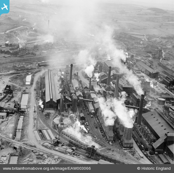
EAW003066 ENGLAND (1946). The Devonshire Works, Staveley, 1946
© Copyright OpenStreetMap contributors and licensed by the OpenStreetMap Foundation. 2026. Cartography is licensed as CC BY-SA.
Nearby Images (20)
Details
| Title | [EAW003066] The Devonshire Works, Staveley, 1946 |
| Reference | EAW003066 |
| Date | 8-October-1946 |
| Link | |
| Place name | STAVELEY |
| Parish | STAVELEY |
| District | |
| Country | ENGLAND |
| Easting / Northing | 442330, 374845 |
| Longitude / Latitude | -1.3652368018857, 53.268628206588 |
| National Grid Reference | SK423748 |
Pins

eric watts |
Sunday 31st of August 2014 01:51:10 PM | |

eric watts |
Sunday 31st of August 2014 01:50:17 PM |


![[EAW003066] The Devonshire Works, Staveley, 1946](http://britainfromabove.org.uk/sites/all/libraries/aerofilms-images/public/100x100/EAW/003/EAW003066.jpg)
![[EPW041682] The Devonshire Iron and Chemical Works, Staveley, 1933](http://britainfromabove.org.uk/sites/all/libraries/aerofilms-images/public/100x100/EPW/041/EPW041682.jpg)
![[EPW041681] The Devonshire Iron and Chemical Works, Staveley, 1933](http://britainfromabove.org.uk/sites/all/libraries/aerofilms-images/public/100x100/EPW/041/EPW041681.jpg)
![[EPW041679] The Devonshire Iron and Chemical Works, Staveley, 1933](http://britainfromabove.org.uk/sites/all/libraries/aerofilms-images/public/100x100/EPW/041/EPW041679.jpg)
![[EPW041673] The Devonshire Iron and Chemical Works, Staveley, 1933](http://britainfromabove.org.uk/sites/all/libraries/aerofilms-images/public/100x100/EPW/041/EPW041673.jpg)
![[EPW041678] The Devonshire Iron and Chemical Works, Staveley, 1933](http://britainfromabove.org.uk/sites/all/libraries/aerofilms-images/public/100x100/EPW/041/EPW041678.jpg)
![[EPW057353] The Staveley Coal and Iron Company Ltd Works, Staveley, 1938](http://britainfromabove.org.uk/sites/all/libraries/aerofilms-images/public/100x100/EPW/057/EPW057353.jpg)
![[EAW044350] The Staveley Coal and Iron Company Ltd Works, Staveley, 1952](http://britainfromabove.org.uk/sites/all/libraries/aerofilms-images/public/100x100/EAW/044/EAW044350.jpg)
![[EAW003062] The Devonshire Works, Staveley, 1946](http://britainfromabove.org.uk/sites/all/libraries/aerofilms-images/public/100x100/EAW/003/EAW003062.jpg)
![[EAW003069] The Devonshire Works, Staveley, 1946](http://britainfromabove.org.uk/sites/all/libraries/aerofilms-images/public/100x100/EAW/003/EAW003069.jpg)
![[EPW057336] The Staveley Coal and Iron Company Ltd Works, Staveley, 1938](http://britainfromabove.org.uk/sites/all/libraries/aerofilms-images/public/100x100/EPW/057/EPW057336.jpg)
![[EPW057344] The Staveley Coal and Iron Company Ltd Works, Staveley, 1938](http://britainfromabove.org.uk/sites/all/libraries/aerofilms-images/public/100x100/EPW/057/EPW057344.jpg)
![[EPW041676] The Devonshire Iron and Chemical Works, Staveley, 1933](http://britainfromabove.org.uk/sites/all/libraries/aerofilms-images/public/100x100/EPW/041/EPW041676.jpg)
![[EPW057332] The Staveley Coal and Iron Company Ltd Works, Staveley, 1938](http://britainfromabove.org.uk/sites/all/libraries/aerofilms-images/public/100x100/EPW/057/EPW057332.jpg)
![[EPW057354] The Staveley Coal and Iron Company Ltd Works, Staveley, 1938](http://britainfromabove.org.uk/sites/all/libraries/aerofilms-images/public/100x100/EPW/057/EPW057354.jpg)
![[EPW057338] The Staveley Coal and Iron Company Ltd Works, Staveley, 1938](http://britainfromabove.org.uk/sites/all/libraries/aerofilms-images/public/100x100/EPW/057/EPW057338.jpg)
![[EPW041680] The Devonshire Iron and Chemical Works, Staveley, 1933](http://britainfromabove.org.uk/sites/all/libraries/aerofilms-images/public/100x100/EPW/041/EPW041680.jpg)
![[EAW044349] The Staveley Coal and Iron Company Ltd Works, Staveley, 1952](http://britainfromabove.org.uk/sites/all/libraries/aerofilms-images/public/100x100/EAW/044/EAW044349.jpg)
![[EAW003063] The Devonshire Works, Staveley, from the south-east, 1946](http://britainfromabove.org.uk/sites/all/libraries/aerofilms-images/public/100x100/EAW/003/EAW003063.jpg)
![[EAW003068] The Devonshire Works and environs, Staveley, from the north-west, 1946](http://britainfromabove.org.uk/sites/all/libraries/aerofilms-images/public/100x100/EAW/003/EAW003068.jpg)