
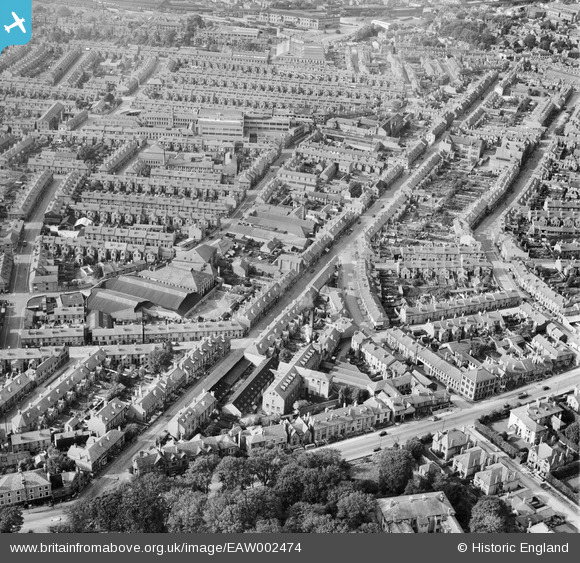
EAW002474 ENGLAND (1946). Ernest Turner Spa Lane Mills and Abbey Street, Derby, 1946
© Copyright OpenStreetMap contributors and licensed by the OpenStreetMap Foundation. 2026. Cartography is licensed as CC BY-SA.
Nearby Images (8)
EAW002474

EAW002471

EAW002475

EAW002469

EAW002470

EAW002472

EAW002473

EPW055019

Details
| Title | [EAW002474] Ernest Turner Spa Lane Mills and Abbey Street, Derby, 1946 |
| Reference | EAW002474 |
| Date | 6-September-1946 |
| Link | |
| Place name | DERBY |
| Parish | |
| District | |
| Country | ENGLAND |
| Easting / Northing | 434820, 335491 |
| Longitude / Latitude | -1.4821131505155, 52.915393542508 |
| National Grid Reference | SK348355 |
Pins

60's Soul |
Monday 2nd of February 2026 06:10:17 AM | |
|
60's Soul |
Monday 2nd of February 2026 06:09:33 AM | |
|
60's Soul |
Monday 2nd of February 2026 06:00:10 AM | |
|
60's Soul |
Monday 2nd of February 2026 05:59:36 AM | |
|
60's Soul |
Monday 2nd of February 2026 05:53:08 AM | |
|
60's Soul |
Monday 2nd of February 2026 05:51:59 AM | |
|
60's Soul |
Monday 2nd of February 2026 05:43:56 AM | |
|
60's Soul |
Monday 2nd of February 2026 05:41:30 AM | |
|
60's Soul |
Monday 2nd of February 2026 05:35:22 AM | |
|
60's Soul |
Monday 2nd of February 2026 05:34:30 AM | |
|
60's Soul |
Monday 2nd of February 2026 05:28:27 AM | |
|
60's Soul |
Monday 2nd of February 2026 05:26:56 AM | |
|
60's Soul |
Monday 2nd of February 2026 05:21:40 AM | |
|
60's Soul |
Monday 2nd of February 2026 05:19:27 AM |