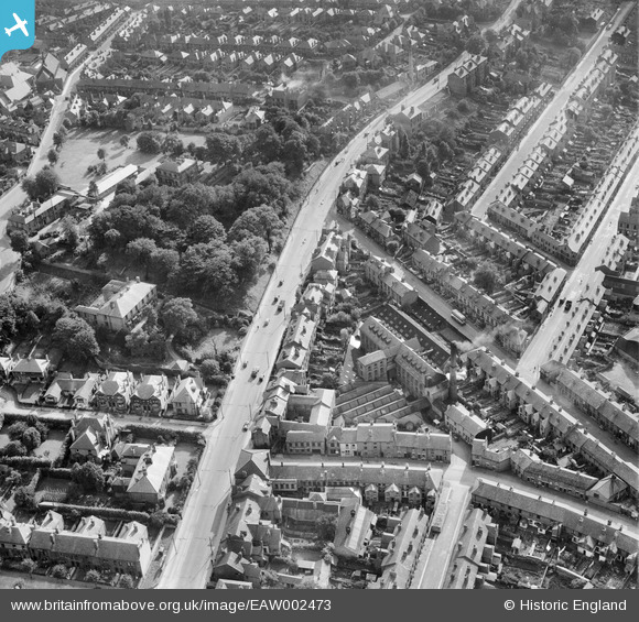
EAW002473 ENGLAND (1946). Ernest Turner Spa Lane Mills and Burton Road, Derby, 1946
© Copyright OpenStreetMap contributors and licensed by the OpenStreetMap Foundation. 2026. Cartography is licensed as CC BY-SA.
Nearby Images (8)
Details
| Title | [EAW002473] Ernest Turner Spa Lane Mills and Burton Road, Derby, 1946 |
| Reference | EAW002473 |
| Date | 6-September-1946 |
| Link | |
| Place name | DERBY |
| Parish | |
| District | |
| Country | ENGLAND |
| Easting / Northing | 434869, 335338 |
| Longitude / Latitude | -1.4814008242723, 52.914014897144 |
| National Grid Reference | SK349353 |
Pins

Andy Savage |
Tuesday 3rd of June 2025 12:41:46 PM | |

Andy |
Sunday 18th of October 2020 12:57:08 AM | |

Andy |
Sunday 18th of October 2020 12:55:43 AM | |

Sparky |
Sunday 17th of September 2017 03:06:15 PM | |

Steve H |
Tuesday 10th of November 2015 12:05:18 AM | |

Steve H |
Tuesday 10th of November 2015 12:01:59 AM | |

Steve H |
Monday 9th of November 2015 11:56:43 PM | |

Steve H |
Monday 9th of November 2015 11:56:19 PM | |

Steve H |
Monday 9th of November 2015 11:55:52 PM | |

Steve H |
Monday 9th of November 2015 11:55:27 PM |
User Comment Contributions
I think this is Spa Lane Mills where I used to work in Spa Lane in the 60s. I would like to see some better pictures if someone can supply them...? Laurence Breedon |

spalanemills |
Tuesday 8th of September 2015 04:43:50 PM |


![[EAW002473] Ernest Turner Spa Lane Mills and Burton Road, Derby, 1946](http://britainfromabove.org.uk/sites/all/libraries/aerofilms-images/public/100x100/EAW/002/EAW002473.jpg)
![[EAW002470] Burton Road at Spa Lane and environs, Derby, 1946](http://britainfromabove.org.uk/sites/all/libraries/aerofilms-images/public/100x100/EAW/002/EAW002470.jpg)
![[EAW002472] Ernest Turner Spa Lane Mills, Burton Road and environs, Derby, 1946](http://britainfromabove.org.uk/sites/all/libraries/aerofilms-images/public/100x100/EAW/002/EAW002472.jpg)
![[EAW002475] Ernest Turner Spa Lane Mills and Abbey Street, Derby, 1946](http://britainfromabove.org.uk/sites/all/libraries/aerofilms-images/public/100x100/EAW/002/EAW002475.jpg)
![[EAW002471] Ernest Turner Spa Lane Mills and environs, Derby, 1946](http://britainfromabove.org.uk/sites/all/libraries/aerofilms-images/public/100x100/EAW/002/EAW002471.jpg)
![[EAW002474] Ernest Turner Spa Lane Mills and Abbey Street, Derby, 1946](http://britainfromabove.org.uk/sites/all/libraries/aerofilms-images/public/100x100/EAW/002/EAW002474.jpg)
![[EAW002469] Ernest Turner Spa Lane Mills and environs, Derby, 1946](http://britainfromabove.org.uk/sites/all/libraries/aerofilms-images/public/100x100/EAW/002/EAW002469.jpg)
![[EPW055019] The Derby Brick Co Ltd Brickworks, Abbey Street and the city, Derby, from the south-west, 1937](http://britainfromabove.org.uk/sites/all/libraries/aerofilms-images/public/100x100/EPW/055/EPW055019.jpg)