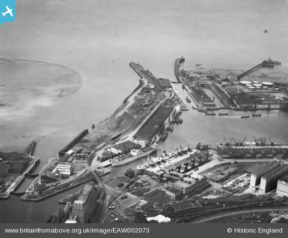
EAW002073 ENGLAND (1946). Avonmouth Docks, Avonmouth, 1946. This image has been produced from a print.
© Copyright OpenStreetMap contributors and licensed by the OpenStreetMap Foundation. 2026. Cartography is licensed as CC BY-SA.
Nearby Images (14)
Details
| Title | [EAW002073] Avonmouth Docks, Avonmouth, 1946. This image has been produced from a print. |
| Reference | EAW002073 |
| Date | 31-July-1946 |
| Link | |
| Place name | AVONMOUTH |
| Parish | |
| District | |
| Country | ENGLAND |
| Easting / Northing | 350766, 178525 |
| Longitude / Latitude | -2.7094126137692, 51.503029888071 |
| National Grid Reference | ST508785 |
Pins

MB |
Saturday 2nd of January 2021 11:55:09 AM | |

MB |
Saturday 2nd of January 2021 11:54:38 AM | |

MB |
Saturday 2nd of January 2021 11:53:59 AM | |

MB |
Saturday 2nd of January 2021 11:51:36 AM | |

MB |
Saturday 2nd of January 2021 11:48:40 AM | |

MB |
Saturday 2nd of January 2021 11:46:41 AM | |

MB |
Saturday 2nd of January 2021 11:46:13 AM | |

MB |
Saturday 2nd of January 2021 11:44:55 AM | |

redmist |
Tuesday 10th of November 2020 11:36:17 PM | |

redmist |
Tuesday 10th of November 2020 11:35:42 PM |


![[EAW002073] Avonmouth Docks, Avonmouth, 1946. This image has been produced from a print.](http://britainfromabove.org.uk/sites/all/libraries/aerofilms-images/public/100x100/EAW/002/EAW002073.jpg)
![[EPW005504] The Royal Edward Dock, Avonmouth, from the south-west, 1921](http://britainfromabove.org.uk/sites/all/libraries/aerofilms-images/public/100x100/EPW/005/EPW005504.jpg)
![[EAW002057] Avonmouth Docks, Avonmouth, 1946. This image has been produced from a print.](http://britainfromabove.org.uk/sites/all/libraries/aerofilms-images/public/100x100/EAW/002/EAW002057.jpg)
![[EAW002062] Avonmouth Docks, Avonmouth, 1946. This image has been produced from a print.](http://britainfromabove.org.uk/sites/all/libraries/aerofilms-images/public/100x100/EAW/002/EAW002062.jpg)
![[EPW022377] The Royal Edward Dock, Avonmouth, 1928](http://britainfromabove.org.uk/sites/all/libraries/aerofilms-images/public/100x100/EPW/022/EPW022377.jpg)
![[EPW022378] The Royal Edward Dock, Avonmouth, 1928](http://britainfromabove.org.uk/sites/all/libraries/aerofilms-images/public/100x100/EPW/022/EPW022378.jpg)
![[EPW046968] The Royal Edward Dock and environs, Avonmouth, from the south, 1935](http://britainfromabove.org.uk/sites/all/libraries/aerofilms-images/public/100x100/EPW/046/EPW046968.jpg)
![[EAW002056] Avonmouth Docks, Avonmouth, 1946](http://britainfromabove.org.uk/sites/all/libraries/aerofilms-images/public/100x100/EAW/002/EAW002056.jpg)
![[EPW005525] The Royal Edward Dock, Avonmouth, from the south-west, 1921](http://britainfromabove.org.uk/sites/all/libraries/aerofilms-images/public/100x100/EPW/005/EPW005525.jpg)
![[EPW005506] The Entrance Lock to The Royal Edward Dock, Avonmouth, 1921](http://britainfromabove.org.uk/sites/all/libraries/aerofilms-images/public/100x100/EPW/005/EPW005506.jpg)
![[EPW005502] The Royal Edward Dock, Avonmouth, from the south-west, 1921](http://britainfromabove.org.uk/sites/all/libraries/aerofilms-images/public/100x100/EPW/005/EPW005502.jpg)
![[EAW002058] The Royal Edward Dock, Avonmouth, 1946](http://britainfromabove.org.uk/sites/all/libraries/aerofilms-images/public/100x100/EAW/002/EAW002058.jpg)
![[EAW002061] Avonmouth Docks, Avonmouth, 1946. This image has been produced from a print.](http://britainfromabove.org.uk/sites/all/libraries/aerofilms-images/public/100x100/EAW/002/EAW002061.jpg)
![[EPW046969] The Royal Edward Dock and environs, Avonmouth, from the south, 1935](http://britainfromabove.org.uk/sites/all/libraries/aerofilms-images/public/100x100/EPW/046/EPW046969.jpg)