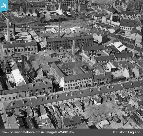
EAW001862 ENGLAND (1946). The Patterson and Stone Warehouse and the surrounding industrial area, Walsall, 1946
© Copyright OpenStreetMap contributors and licensed by the OpenStreetMap Foundation. 2026. Cartography is licensed as CC BY-SA.
Nearby Images (12)
Details
| Title | [EAW001862] The Patterson and Stone Warehouse and the surrounding industrial area, Walsall, 1946 |
| Reference | EAW001862 |
| Date | 12-July-1946 |
| Link | |
| Place name | WALSALL |
| Parish | |
| District | |
| Country | ENGLAND |
| Easting / Northing | 400853, 298511 |
| Longitude / Latitude | -1.9874090411623, 52.584049258721 |
| National Grid Reference | SP009985 |
Pins

kevofbrum |
Sunday 3rd of July 2016 05:12:20 PM | |

kevofbrum |
Sunday 3rd of July 2016 05:11:19 PM | |

kevofbrum |
Sunday 3rd of July 2016 05:10:05 PM | |

kevofbrum |
Sunday 3rd of July 2016 05:09:48 PM | |

kevofbrum |
Sunday 3rd of July 2016 05:09:32 PM |


![[EAW001862] The Patterson and Stone Warehouse and the surrounding industrial area, Walsall, 1946](http://britainfromabove.org.uk/sites/all/libraries/aerofilms-images/public/100x100/EAW/001/EAW001862.jpg)
![[EAW001859] The Patterson and Stone Warehouse and the surrounding industrial area, Walsall, 1946](http://britainfromabove.org.uk/sites/all/libraries/aerofilms-images/public/100x100/EAW/001/EAW001859.jpg)
![[EAW001858] The Patterson and Stone Warehouse and the surrounding industrial area, Walsall, 1946](http://britainfromabove.org.uk/sites/all/libraries/aerofilms-images/public/100x100/EAW/001/EAW001858.jpg)
![[EAW001861] The Patterson and Stone Warehouse and the surrounding industrial area, Walsall, 1946](http://britainfromabove.org.uk/sites/all/libraries/aerofilms-images/public/100x100/EAW/001/EAW001861.jpg)
![[EAW001860] The Patterson and Stone Warehouse and the surrounding industrial area, Walsall, 1946](http://britainfromabove.org.uk/sites/all/libraries/aerofilms-images/public/100x100/EAW/001/EAW001860.jpg)
![[EAW001854] The Walsall Leather Dressing Co Works and the surrounding residential area off Frederick Street, Walsall, 1946](http://britainfromabove.org.uk/sites/all/libraries/aerofilms-images/public/100x100/EAW/001/EAW001854.jpg)
![[EAW001857] The Walsall Leather Dressing Co Works and the surrounding residential area, Walsall, 1946](http://britainfromabove.org.uk/sites/all/libraries/aerofilms-images/public/100x100/EAW/001/EAW001857.jpg)
![[EAW001855] The Walsall Leather Dressing Co Works and the Kirkpatrick Ltd Iron Foundry off Frederick Street, Walsall, 1946](http://britainfromabove.org.uk/sites/all/libraries/aerofilms-images/public/100x100/EAW/001/EAW001855.jpg)
![[EAW001856] The Walsall Leather Dressing Co Works and the surrounding residential area, Walsall, 1946](http://britainfromabove.org.uk/sites/all/libraries/aerofilms-images/public/100x100/EAW/001/EAW001856.jpg)
![[EAW001853] The Walsall Leather Dressing Co Works and the Kirkpatrick Ltd Iron Foundry off Frederick Street, Walsall, 1946](http://britainfromabove.org.uk/sites/all/libraries/aerofilms-images/public/100x100/EAW/001/EAW001853.jpg)
![[EPW005671] The Railway Station and Goods Yards, Walsall, 1921](http://britainfromabove.org.uk/sites/all/libraries/aerofilms-images/public/100x100/EPW/005/EPW005671.jpg)
![[EAW039989] The H. W. Lindop and Sons Junction Foundry off Pleck Road and the surrounding area, Walsall, 1951. This image was marked by Aerofilms Ltd for photo editing.](http://britainfromabove.org.uk/sites/all/libraries/aerofilms-images/public/100x100/EAW/039/EAW039989.jpg)