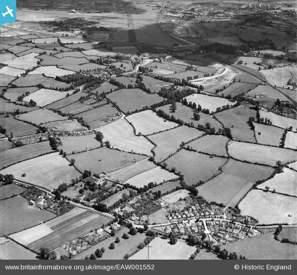
EAW001552 ENGLAND (1946). Housing at The Close, Charlton Common and the surrounding countryside, Catbrain, 1946
© Copyright OpenStreetMap contributors and licensed by the OpenStreetMap Foundation. 2026. Cartography is licensed as CC BY-SA.
Nearby Images (15)
Details
| Title | [EAW001552] Housing at The Close, Charlton Common and the surrounding countryside, Catbrain, 1946 |
| Reference | EAW001552 |
| Date | 15-July-1946 |
| Link | |
| Place name | CATBRAIN |
| Parish | ALMONDSBURY |
| District | |
| Country | ENGLAND |
| Easting / Northing | 357599, 180217 |
| Longitude / Latitude | -2.6111659887136, 51.518798419005 |
| National Grid Reference | ST576802 |
Pins

Class31 |
Wednesday 3rd of June 2015 07:06:05 AM | |

Buzzard |
Tuesday 19th of May 2015 11:40:05 PM | |

Buzzard |
Tuesday 19th of May 2015 11:37:32 PM | |

Buzzard |
Tuesday 19th of May 2015 11:36:50 PM | |

Buzzard |
Tuesday 19th of May 2015 11:34:49 PM | |

Buzzard |
Tuesday 19th of May 2015 11:01:59 PM | |

Buzzard |
Tuesday 19th of May 2015 10:50:50 PM |


![[EAW001552] Housing at The Close, Charlton Common and the surrounding countryside, Catbrain, 1946](http://britainfromabove.org.uk/sites/all/libraries/aerofilms-images/public/100x100/EAW/001/EAW001552.jpg)
![[EAW007131] Bristol Filton Airport under construction, Catbrain, from the west, 1947](http://britainfromabove.org.uk/sites/all/libraries/aerofilms-images/public/100x100/EAW/007/EAW007131.jpg)
![[EAW001555] Housing at The Close, Charlton Common and Bristol Filton Airport in the distance, Catbrain, 1946](http://britainfromabove.org.uk/sites/all/libraries/aerofilms-images/public/100x100/EAW/001/EAW001555.jpg)
![[EAW007145] Bristol Filton Airport under construction, Catbrain, from the west, 1947](http://britainfromabove.org.uk/sites/all/libraries/aerofilms-images/public/100x100/EAW/007/EAW007145.jpg)
![[EAW009953] The western end of Bristol Filton Airport under construction, Catbrain, 1947](http://britainfromabove.org.uk/sites/all/libraries/aerofilms-images/public/100x100/EAW/009/EAW009953.jpg)
![[EAW007138] Bristol Filton Airport under construction, Catbrain, from the west, 1947](http://britainfromabove.org.uk/sites/all/libraries/aerofilms-images/public/100x100/EAW/007/EAW007138.jpg)
![[EAW004181] Bristol Filton Airport showing the main runway being extended, Catbrain, from the west, 1947](http://britainfromabove.org.uk/sites/all/libraries/aerofilms-images/public/100x100/EAW/004/EAW004181.jpg)
![[EAW001548] The village and the surrounding countryside, Catbrain, 1946](http://britainfromabove.org.uk/sites/all/libraries/aerofilms-images/public/100x100/EAW/001/EAW001548.jpg)
![[EAW003557] The Aeroplane Arrester under construction at Bristol Filton Airport, Catbrain, 1947](http://britainfromabove.org.uk/sites/all/libraries/aerofilms-images/public/100x100/EAW/003/EAW003557.jpg)
![[EAW027786] Bristol 167 Brabazon Mk1 G-AGPW on the runway at Bristol Filton Airport, Catbrain, from the west, 1949. This image was marked by Aerofilms Ltd for photo editing.](http://britainfromabove.org.uk/sites/all/libraries/aerofilms-images/public/100x100/EAW/027/EAW027786.jpg)
![[EAW027776] Bristol 167 Brabazon Mk1 G-AGPW on the runway at Bristol Filton Airport, Catbrain, from the west, 1949. This image has been produced from a print.](http://britainfromabove.org.uk/sites/all/libraries/aerofilms-images/public/100x100/EAW/027/EAW027776.jpg)
![[EAW009955] The western end of Bristol Filton Airport under construction, Catbrain, 1947](http://britainfromabove.org.uk/sites/all/libraries/aerofilms-images/public/100x100/EAW/009/EAW009955.jpg)
![[EAW009951] Bristol Filton Airport under construction and the surrounding countryside, Catbrain, from the west, 1947](http://britainfromabove.org.uk/sites/all/libraries/aerofilms-images/public/100x100/EAW/009/EAW009951.jpg)
![[EAW001549] The village and the surrounding countryside, Catbrain, 1946](http://britainfromabove.org.uk/sites/all/libraries/aerofilms-images/public/100x100/EAW/001/EAW001549.jpg)
![[EAW027779] Bristol 167 Brabazon Mk1 G-AGPW on the runway at Bristol Filton Airport, Catbrain, from the west, 1949. This image was marked by Aerofilms Ltd for photo editing.](http://britainfromabove.org.uk/sites/all/libraries/aerofilms-images/public/100x100/EAW/027/EAW027779.jpg)