
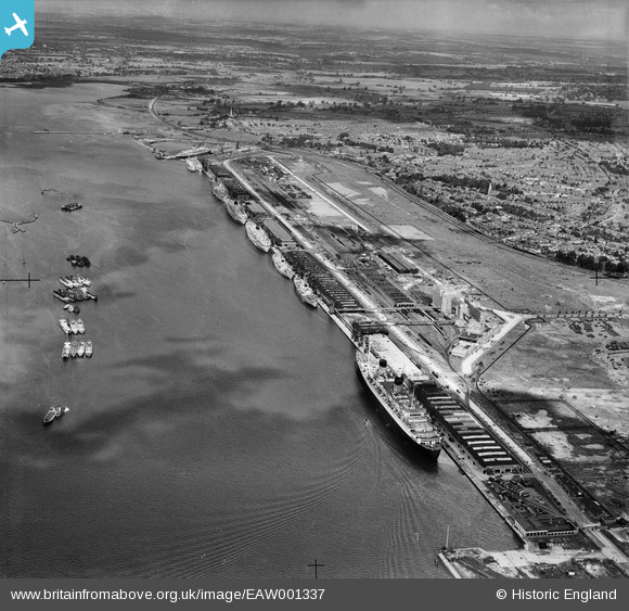
EAW001337 ENGLAND (1946). The New Docks (Western Docks), Southampton, from the south-east, 1946
© Copyright OpenStreetMap contributors and licensed by the OpenStreetMap Foundation. 2026. Cartography is licensed as CC BY-SA.
Nearby Images (14)
EAW001337
, Southampton, from the south-east, 1946")
EAW002825
 and RMS Queen Elizabeth at the New Docks (Western Docks), Southampton, from the south, 1946")
EAW001344
, Southampton, from the south, 1946")
EAW001338
, Southampton, 1946")
EAW001343
, Southampton, from the south-east, 1946")
EAW001339
, Southampton, from the south-east, 1946")
EAW001363
, Southampton, from the south-west, 1946")
EAW035617

EAW020013

EAW035618

EAW001362
, Southampton, 1946")
EAW020019

EAW035620

EAW004217

Details
| Title | [EAW001337] The New Docks (Western Docks), Southampton, from the south-east, 1946 |
| Reference | EAW001337 |
| Date | 28-June-1946 |
| Link | |
| Place name | SOUTHAMPTON |
| Parish | |
| District | |
| Country | ENGLAND |
| Easting / Northing | 440869, 111378 |
| Longitude / Latitude | -1.4187604489949, 50.899877713409 |
| National Grid Reference | SU409114 |
Pins

redmist |
Wednesday 21st of December 2022 01:12:06 PM | |
|
redmist |
Wednesday 21st of December 2022 01:11:37 PM | |
|
redmist |
Wednesday 21st of December 2022 01:10:04 PM | |
|
redmist |
Wednesday 21st of December 2022 12:15:24 PM | |
|
redmist |
Monday 5th of December 2022 08:59:40 PM | |
|
redmist |
Monday 5th of December 2022 08:58:58 PM | |
|
redmist |
Monday 5th of December 2022 08:44:13 PM | |
|
redmist |
Monday 5th of December 2022 08:36:53 PM | |

Class31 |
Thursday 12th of February 2015 08:36:40 PM | |
|
Graham Yaxley |
Monday 5th of January 2015 12:03:22 AM | |
|
Graham Yaxley |
Monday 5th of January 2015 12:02:48 AM | |
|
Nicholas III |
Friday 6th of September 2013 06:53:36 PM | |

Maurice |
Wednesday 28th of August 2013 08:16:20 AM | |
|
Maurice |
Wednesday 28th of August 2013 08:08:37 AM | |
Train tracks and concrete apron built shortly before D-Day to allow trucks to be loaded into two Landing Ship Tanks |
Jessie Russel |
Monday 7th of July 2025 10:13:35 PM |

User Comment Contributions
Western Docks, Southampton, 12/02/2015 |
Class31 |
Thursday 12th of February 2015 08:37:34 PM |