
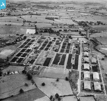
EAW001099 ENGLAND (1946). RAF Hereford (Credenhill), Credenhill, 1946

© Copyright OpenStreetMap contributors and licensed by the OpenStreetMap Foundation. 2026. Cartography is licensed as CC BY-SA.
Nearby Images (10)
EAW001099
, Credenhill, 1946")
EAW001103
, Credenhill, 1946")
EAW001102
, Credenhill, 1946")
EAW001100
, Credenhill, 1946")
EAW001105
, Credenhill, 1946")
EAW001096
, Credenhill, 1946")
EAW001095
, Credenhill, 1946")
EAW001104
, Credenhill, 1946")
EAW001101
, Credenhill, 1946")
EAW001097
, Credenhill, 1946")
Details
| Title | [EAW001099] RAF Hereford (Credenhill), Credenhill, 1946 |
| Reference | EAW001099 |
| Date | 16-June-1946 |
| Link | |
| Place name | CREDENHILL |
| Parish | CREDENHILL |
| District | |
| Country | ENGLAND |
| Easting / Northing | 345591, 243161 |
| Longitude / Latitude | -2.7941146118329, 52.083710712524 |
| National Grid Reference | SO456432 |
Pins
User Comment Contributions
RAF Hereford (Credenhill), Credenhill, 1946 |

Hollybush |
Saturday 24th of August 2013 11:12:02 AM |