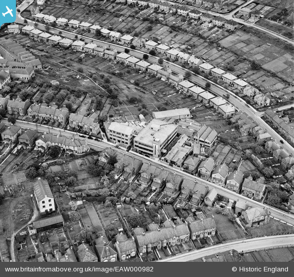
EAW000982 ENGLAND (1946). Bowerdean Road and Ernest Turner's Chiltern Works on Totteridge Avenue, High Wycombe, 1946
© Copyright OpenStreetMap contributors and licensed by the OpenStreetMap Foundation. 2025. Cartography is licensed as CC BY-SA.
Nearby Images (25)
Details
| Title | [EAW000982] Bowerdean Road and Ernest Turner's Chiltern Works on Totteridge Avenue, High Wycombe, 1946 |
| Reference | EAW000982 |
| Date | 28-May-1946 |
| Link | |
| Place name | HIGH WYCOMBE |
| Parish | |
| District | |
| Country | ENGLAND |
| Easting / Northing | 487620, 192920 |
| Longitude / Latitude | -0.73400717648144, 51.627795746837 |
| National Grid Reference | SU876929 |
Pins
Be the first to add a comment to this image!


![[EAW000982] Bowerdean Road and Ernest Turner's Chiltern Works on Totteridge Avenue, High Wycombe, 1946](http://britainfromabove.org.uk/sites/all/libraries/aerofilms-images/public/100x100/EAW/000/EAW000982.jpg)
![[EAW000986] Bowerdean Road and Ernest Turner's Chiltern Works on Totteridge Avenue, High Wycombe, 1946](http://britainfromabove.org.uk/sites/all/libraries/aerofilms-images/public/100x100/EAW/000/EAW000986.jpg)
![[EAW000988] Bowerdean Road and Ernest Turner's Chiltern Works on Totteridge Avenue, High Wycombe, 1946](http://britainfromabove.org.uk/sites/all/libraries/aerofilms-images/public/100x100/EAW/000/EAW000988.jpg)
![[EAW000983] Bowerdean Road and Ernest Turner's Chiltern Works on Totteridge Avenue, High Wycombe, 1946](http://britainfromabove.org.uk/sites/all/libraries/aerofilms-images/public/100x100/EAW/000/EAW000983.jpg)
![[EAW000984] Bowerdean Road and Ernest Turner's Chiltern Works on Totteridge Avenue, High Wycombe, 1946](http://britainfromabove.org.uk/sites/all/libraries/aerofilms-images/public/100x100/EAW/000/EAW000984.jpg)
![[EAW000985] Bowerdean Road and Ernest Turner's Chiltern Works on Totteridge Avenue, High Wycombe, 1946](http://britainfromabove.org.uk/sites/all/libraries/aerofilms-images/public/100x100/EAW/000/EAW000985.jpg)
![[EAW000987] Ernest Turner's Chiltern Works, High Wycombe, 1946](http://britainfromabove.org.uk/sites/all/libraries/aerofilms-images/public/100x100/EAW/000/EAW000987.jpg)
![[EAW000989] Ernest Turner's Chiltern Works, High Wycombe, 1946](http://britainfromabove.org.uk/sites/all/libraries/aerofilms-images/public/100x100/EAW/000/EAW000989.jpg)
![[EAW040089] The Standard Works (William S. Toms Bedding Factory) off Totteridge Road, High Wycombe, 1951. This image was marked by Aerofilms Ltd for photo editing.](http://britainfromabove.org.uk/sites/all/libraries/aerofilms-images/public/100x100/EAW/040/EAW040089.jpg)
![[EAW040085] The Standard Works (William S. Toms Bedding Factory) off Totteridge Road, High Wycombe, 1951](http://britainfromabove.org.uk/sites/all/libraries/aerofilms-images/public/100x100/EAW/040/EAW040085.jpg)
![[EAW040091] The Standard Works (William S. Toms Bedding Factory) off Totteridge Road, High Wycombe, 1951. This image was marked by Aerofilms Ltd for photo editing.](http://britainfromabove.org.uk/sites/all/libraries/aerofilms-images/public/100x100/EAW/040/EAW040091.jpg)
![[EAW040092] The Standard Works (William S. Toms Bedding Factory) off Totteridge Road, High Wycombe, 1951. This image was marked by Aerofilms Ltd for photo editing.](http://britainfromabove.org.uk/sites/all/libraries/aerofilms-images/public/100x100/EAW/040/EAW040092.jpg)
![[EAW040088] The Standard Works (William S. Toms Bedding Factory) off Totteridge Road, High Wycombe, 1951. This image was marked by Aerofilms Ltd for photo editing.](http://britainfromabove.org.uk/sites/all/libraries/aerofilms-images/public/100x100/EAW/040/EAW040088.jpg)
![[EAW040090] The Standard Works (William S. Toms Bedding Factory) off Totteridge Road, High Wycombe, 1951. This image was marked by Aerofilms Ltd for photo editing.](http://britainfromabove.org.uk/sites/all/libraries/aerofilms-images/public/100x100/EAW/040/EAW040090.jpg)
![[EAW040086] The Standard Works (William S. Toms Bedding Factory) off Totteridge Road, High Wycombe, 1951. This image was marked by Aerofilms Ltd for photo editing.](http://britainfromabove.org.uk/sites/all/libraries/aerofilms-images/public/100x100/EAW/040/EAW040086.jpg)
![[EAW040087] The Standard Works (William S. Toms Bedding Factory) off Totteridge Road, High Wycombe, 1951. This image was marked by Aerofilms Ltd for photo editing.](http://britainfromabove.org.uk/sites/all/libraries/aerofilms-images/public/100x100/EAW/040/EAW040087.jpg)
![[EAW003773] Long & Hambly Ltd Works, High Wycombe, 1947](http://britainfromabove.org.uk/sites/all/libraries/aerofilms-images/public/100x100/EAW/003/EAW003773.jpg)
![[EAW003768] Long & Hambly Ltd Works and environs, High Wycombe, from the south, 1947](http://britainfromabove.org.uk/sites/all/libraries/aerofilms-images/public/100x100/EAW/003/EAW003768.jpg)
![[EAW003777] Long & Hambly Ltd Works and environs, High Wycombe, 1947](http://britainfromabove.org.uk/sites/all/libraries/aerofilms-images/public/100x100/EAW/003/EAW003777.jpg)
![[EAW003776] Long & Hambly Ltd Works and environs, High Wycombe, 1947](http://britainfromabove.org.uk/sites/all/libraries/aerofilms-images/public/100x100/EAW/003/EAW003776.jpg)
![[EAW003772] Long & Hambly Ltd Works and environs, High Wycombe, from the south, 1947](http://britainfromabove.org.uk/sites/all/libraries/aerofilms-images/public/100x100/EAW/003/EAW003772.jpg)
![[EAW003774] Long & Hambly Ltd Works, High Wycombe, 1947](http://britainfromabove.org.uk/sites/all/libraries/aerofilms-images/public/100x100/EAW/003/EAW003774.jpg)
![[EAW003775] Long & Hambly Ltd Works, High Wycombe, 1947](http://britainfromabove.org.uk/sites/all/libraries/aerofilms-images/public/100x100/EAW/003/EAW003775.jpg)
![[EPW038397] E. Gomme Ltd. Furniture Works and environs, High Wycombe, from the north-west, 1932](http://britainfromabove.org.uk/sites/all/libraries/aerofilms-images/public/100x100/EPW/038/EPW038397.jpg)
![[EAW023174] The E Gomme Ltd Furniture Factory and environs, High Wycombe, from the north-west, 1949. This image was marked by Aerofilms Ltd for photo editing.](http://britainfromabove.org.uk/sites/all/libraries/aerofilms-images/public/100x100/EAW/023/EAW023174.jpg)