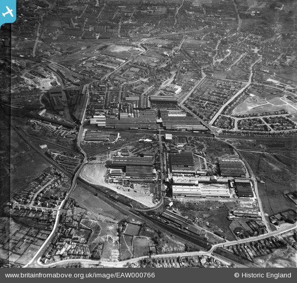
EAW000766 ENGLAND (1946). The Rubery, Owen & Co Ltd Works, Willenhall, 1946
© Copyright OpenStreetMap contributors and licensed by the OpenStreetMap Foundation. 2025. Cartography is licensed as CC BY-SA.
Nearby Images (16)
Details
| Title | [EAW000766] The Rubery, Owen & Co Ltd Works, Willenhall, 1946 |
| Reference | EAW000766 |
| Date | 11-May-1946 |
| Link | |
| Place name | WILLENHALL |
| Parish | |
| District | |
| Country | ENGLAND |
| Easting / Northing | 397494, 297864 |
| Longitude / Latitude | -2.0369856543892, 52.578227070271 |
| National Grid Reference | SO975979 |
Pins
 redmist |
Wednesday 12th of October 2022 01:24:46 PM | |
 redmist |
Wednesday 12th of October 2022 01:23:03 PM | |
 redmist |
Wednesday 12th of October 2022 01:22:30 PM | |
 redmist |
Wednesday 12th of October 2022 01:21:54 PM | |
 robtew |
Wednesday 12th of November 2014 11:22:17 AM | |
 robtew |
Wednesday 12th of November 2014 11:18:36 AM | |
 robtew |
Wednesday 12th of November 2014 11:17:33 AM | |
 Class31 |
Monday 17th of March 2014 11:21:47 PM | |
 Class31 |
Monday 17th of March 2014 11:21:10 PM | |
 Class31 |
Monday 17th of March 2014 11:20:50 PM | |
 Class31 |
Monday 17th of March 2014 11:20:21 PM | |
 Class31 |
Monday 17th of March 2014 11:20:04 PM | |
 Class31 |
Monday 17th of March 2014 11:19:45 PM | |
 Class31 |
Monday 17th of March 2014 11:19:17 PM |


![[EAW000766] The Rubery, Owen & Co Ltd Works, Willenhall, 1946](http://britainfromabove.org.uk/sites/all/libraries/aerofilms-images/public/100x100/EAW/000/EAW000766.jpg)
![[EAW000763] The Rubery, Owen & Co Ltd Works, Willenhall, 1946](http://britainfromabove.org.uk/sites/all/libraries/aerofilms-images/public/100x100/EAW/000/EAW000763.jpg)
![[EAW000768] The Rubery, Owen & Co Ltd Works, Willenhall, 1946](http://britainfromabove.org.uk/sites/all/libraries/aerofilms-images/public/100x100/EAW/000/EAW000768.jpg)
![[EAW047006] The Rubery, Owen and Co Iron Works and environs, Darlaston, 1952. This image was marked by Aerofilms Ltd for photo editing.](http://britainfromabove.org.uk/sites/all/libraries/aerofilms-images/public/100x100/EAW/047/EAW047006.jpg)
![[EAW000765] The Rubery, Owen & Co Ltd Works, Willenhall, 1946](http://britainfromabove.org.uk/sites/all/libraries/aerofilms-images/public/100x100/EAW/000/EAW000765.jpg)
![[EAW000764] The Rubery, Owen & Co Ltd Works, Darlaston, 1946](http://britainfromabove.org.uk/sites/all/libraries/aerofilms-images/public/100x100/EAW/000/EAW000764.jpg)
![[EAW000762] The Rubery, Owen & Co Ltd Works, Darlaston, 1946](http://britainfromabove.org.uk/sites/all/libraries/aerofilms-images/public/100x100/EAW/000/EAW000762.jpg)
![[EAW047005] The Rubery, Owen and Co Iron Works and environs, Darlaston, 1952. This image was marked by Aerofilms Ltd for photo editing.](http://britainfromabove.org.uk/sites/all/libraries/aerofilms-images/public/100x100/EAW/047/EAW047005.jpg)
![[EAW047003] The Rubery, Owen and Co Iron Works and environs, Darlaston, 1952. This image was marked by Aerofilms Ltd for photo editing.](http://britainfromabove.org.uk/sites/all/libraries/aerofilms-images/public/100x100/EAW/047/EAW047003.jpg)
![[EAW047004] The Rubery, Owen and Co Iron Works and environs, Darlaston, 1952. This image was marked by Aerofilms Ltd for photo editing.](http://britainfromabove.org.uk/sites/all/libraries/aerofilms-images/public/100x100/EAW/047/EAW047004.jpg)
![[EAW047008] The Rubery, Owen and Co Iron Works and environs, Darlaston, 1952. This image was marked by Aerofilms Ltd for photo editing.](http://britainfromabove.org.uk/sites/all/libraries/aerofilms-images/public/100x100/EAW/047/EAW047008.jpg)
![[EAW047010] The Rubery, Owen and Co Iron Works and environs, Darlaston, 1952. This image was marked by Aerofilms Ltd for photo editing.](http://britainfromabove.org.uk/sites/all/libraries/aerofilms-images/public/100x100/EAW/047/EAW047010.jpg)
![[EAW000769] The Rubery, Owen & Co Ltd Works, Willenhall, 1946](http://britainfromabove.org.uk/sites/all/libraries/aerofilms-images/public/100x100/EAW/000/EAW000769.jpg)
![[EAW000767] The Rubery, Owen & Co Ltd Works, Willenhall, 1946](http://britainfromabove.org.uk/sites/all/libraries/aerofilms-images/public/100x100/EAW/000/EAW000767.jpg)
![[EAW047009] The Rubery, Owen and Co Iron Works and environs, Darlaston, 1952. This image was marked by Aerofilms Ltd for photo editing.](http://britainfromabove.org.uk/sites/all/libraries/aerofilms-images/public/100x100/EAW/047/EAW047009.jpg)
![[EAW015301] The Willenhall Foundry and the surrounding industrial area, Willenhall, 1948. This image has been produced from a print marked by Aerofilms Ltd for photo editing.](http://britainfromabove.org.uk/sites/all/libraries/aerofilms-images/public/100x100/EAW/015/EAW015301.jpg)