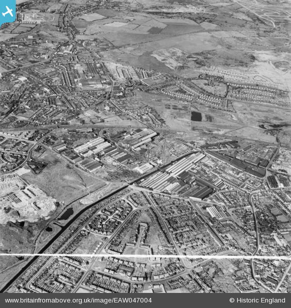
EAW047004 ENGLAND (1952). The Rubery, Owen and Co Iron Works and environs, Darlaston, 1952. This image was marked by Aerofilms Ltd for photo editing.
© Copyright OpenStreetMap contributors and licensed by the OpenStreetMap Foundation. 2025. Cartography is licensed as CC BY-SA.
Nearby Images (15)
Details
| Title | [EAW047004] The Rubery, Owen and Co Iron Works and environs, Darlaston, 1952. This image was marked by Aerofilms Ltd for photo editing. |
| Reference | EAW047004 |
| Date | 23-September-1952 |
| Link | |
| Place name | DARLASTON |
| Parish | |
| District | |
| Country | ENGLAND |
| Easting / Northing | 397445, 298031 |
| Longitude / Latitude | -2.0377101257435, 52.579728314992 |
| National Grid Reference | SO974980 |
Pins
 The First President |
Thursday 18th of March 2021 07:41:43 PM | |
 KevTheBusDriver |
Sunday 28th of June 2015 09:03:16 PM | |
 KevTheBusDriver |
Sunday 28th of June 2015 09:01:45 PM |


![[EAW047004] The Rubery, Owen and Co Iron Works and environs, Darlaston, 1952. This image was marked by Aerofilms Ltd for photo editing.](http://britainfromabove.org.uk/sites/all/libraries/aerofilms-images/public/100x100/EAW/047/EAW047004.jpg)
![[EAW000767] The Rubery, Owen & Co Ltd Works, Willenhall, 1946](http://britainfromabove.org.uk/sites/all/libraries/aerofilms-images/public/100x100/EAW/000/EAW000767.jpg)
![[EAW047006] The Rubery, Owen and Co Iron Works and environs, Darlaston, 1952. This image was marked by Aerofilms Ltd for photo editing.](http://britainfromabove.org.uk/sites/all/libraries/aerofilms-images/public/100x100/EAW/047/EAW047006.jpg)
![[EAW000763] The Rubery, Owen & Co Ltd Works, Willenhall, 1946](http://britainfromabove.org.uk/sites/all/libraries/aerofilms-images/public/100x100/EAW/000/EAW000763.jpg)
![[EAW047007] The Rubery, Owen and Co Iron Works and environs, Darlaston, 1952. This image was marked by Aerofilms Ltd for photo editing.](http://britainfromabove.org.uk/sites/all/libraries/aerofilms-images/public/100x100/EAW/047/EAW047007.jpg)
![[EAW000765] The Rubery, Owen & Co Ltd Works, Willenhall, 1946](http://britainfromabove.org.uk/sites/all/libraries/aerofilms-images/public/100x100/EAW/000/EAW000765.jpg)
![[EAW015301] The Willenhall Foundry and the surrounding industrial area, Willenhall, 1948. This image has been produced from a print marked by Aerofilms Ltd for photo editing.](http://britainfromabove.org.uk/sites/all/libraries/aerofilms-images/public/100x100/EAW/015/EAW015301.jpg)
![[EAW000766] The Rubery, Owen & Co Ltd Works, Willenhall, 1946](http://britainfromabove.org.uk/sites/all/libraries/aerofilms-images/public/100x100/EAW/000/EAW000766.jpg)
![[EAW000768] The Rubery, Owen & Co Ltd Works, Willenhall, 1946](http://britainfromabove.org.uk/sites/all/libraries/aerofilms-images/public/100x100/EAW/000/EAW000768.jpg)
![[EAW000769] The Rubery, Owen & Co Ltd Works, Willenhall, 1946](http://britainfromabove.org.uk/sites/all/libraries/aerofilms-images/public/100x100/EAW/000/EAW000769.jpg)
![[EAW000762] The Rubery, Owen & Co Ltd Works, Darlaston, 1946](http://britainfromabove.org.uk/sites/all/libraries/aerofilms-images/public/100x100/EAW/000/EAW000762.jpg)
![[EAW047005] The Rubery, Owen and Co Iron Works and environs, Darlaston, 1952. This image was marked by Aerofilms Ltd for photo editing.](http://britainfromabove.org.uk/sites/all/libraries/aerofilms-images/public/100x100/EAW/047/EAW047005.jpg)
![[EAW047003] The Rubery, Owen and Co Iron Works and environs, Darlaston, 1952. This image was marked by Aerofilms Ltd for photo editing.](http://britainfromabove.org.uk/sites/all/libraries/aerofilms-images/public/100x100/EAW/047/EAW047003.jpg)
![[EAW015294] The Willenhall Foundry and environs, Willenhall, 1948. This image has been produced from a print marked by Aerofilms Ltd for photo editing.](http://britainfromabove.org.uk/sites/all/libraries/aerofilms-images/public/100x100/EAW/015/EAW015294.jpg)
![[EAW015300] The Willenhall Foundry and environs, Willenhall, 1948. This image has been produced from a print marked by Aerofilms Ltd for photo editing.](http://britainfromabove.org.uk/sites/all/libraries/aerofilms-images/public/100x100/EAW/015/EAW015300.jpg)