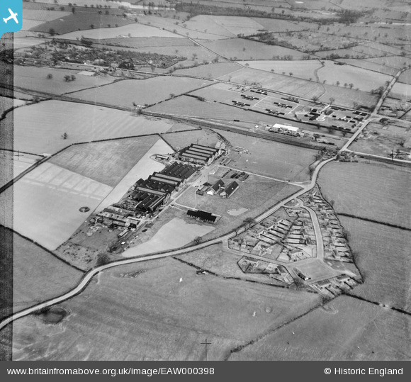
EAW000398 ENGLAND (1946). The Chatwood Safe Company Works and housing at Harlescott Crescent, Harlescott, 1946. This image has been produced from a damaged negative.
© Copyright OpenStreetMap contributors and licensed by the OpenStreetMap Foundation. 2026. Cartography is licensed as CC BY-SA.
Nearby Images (43)
Details
| Title | [EAW000398] The Chatwood Safe Company Works and housing at Harlescott Crescent, Harlescott, 1946. This image has been produced from a damaged negative. |
| Reference | EAW000398 |
| Date | 17-April-1946 |
| Link | |
| Place name | HARLESCOTT |
| Parish | SHREWSBURY |
| District | |
| Country | ENGLAND |
| Easting / Northing | 350665, 316119 |
| Longitude / Latitude | -2.7308274733798, 52.740107170975 |
| National Grid Reference | SJ507161 |


![[EAW000398] The Chatwood Safe Company Works and housing at Harlescott Crescent, Harlescott, 1946. This image has been produced from a damaged negative.](http://britainfromabove.org.uk/sites/all/libraries/aerofilms-images/public/100x100/EAW/000/EAW000398.jpg)
![[EPW023300] The Chatwood Safe Co and environs, Harlescott, from the south-east, 1928](http://britainfromabove.org.uk/sites/all/libraries/aerofilms-images/public/100x100/EPW/023/EPW023300.jpg)
![[EAW001622] The Chatwood Safe Co Ltd, Harlescott, 1946](http://britainfromabove.org.uk/sites/all/libraries/aerofilms-images/public/100x100/EAW/001/EAW001622.jpg)
![[EAW001624] The Chatwood Safe Co Ltd, Harlescott, 1946](http://britainfromabove.org.uk/sites/all/libraries/aerofilms-images/public/100x100/EAW/001/EAW001624.jpg)
![[EAW001626] The Chatwood Safe Co Ltd, Harlescott, 1946](http://britainfromabove.org.uk/sites/all/libraries/aerofilms-images/public/100x100/EAW/001/EAW001626.jpg)
![[EPW028835] The Chatwood Safe Co. Ltd., Harlescott, 1929](http://britainfromabove.org.uk/sites/all/libraries/aerofilms-images/public/100x100/EPW/028/EPW028835.jpg)
![[EAW000397] The Chatwood Safe Company Works and housing at Harlescott Crescent, Harlescott, 1946. This image has been produced from a damaged negative.](http://britainfromabove.org.uk/sites/all/libraries/aerofilms-images/public/100x100/EAW/000/EAW000397.jpg)
![[EAW001625] The Chatwood Safe Co Ltd, Harlescott, 1946](http://britainfromabove.org.uk/sites/all/libraries/aerofilms-images/public/100x100/EAW/001/EAW001625.jpg)
![[EAW000395] The Chatwood Safe Company Works and housing at Harlescott Crescent, Harlescott, 1946. This image has been produced from a damaged negative.](http://britainfromabove.org.uk/sites/all/libraries/aerofilms-images/public/100x100/EAW/000/EAW000395.jpg)
![[EAW001621] The Chatwood Safe Co Ltd, Harlescott, 1946](http://britainfromabove.org.uk/sites/all/libraries/aerofilms-images/public/100x100/EAW/001/EAW001621.jpg)
![[EAW000396] The Chatwood Safe Company Works and housing at Harlescott Crescent, Harlescott, 1946. This image has been produced from a damaged negative.](http://britainfromabove.org.uk/sites/all/libraries/aerofilms-images/public/100x100/EAW/000/EAW000396.jpg)
![[EPW023301] The Chatwood Safe Co and environs, Harlescott, from the south-east, 1928](http://britainfromabove.org.uk/sites/all/libraries/aerofilms-images/public/100x100/EPW/023/EPW023301.jpg)
![[EPW028833] The Chatwood Safe Co. Ltd., Harlescott, 1929](http://britainfromabove.org.uk/sites/all/libraries/aerofilms-images/public/100x100/EPW/028/EPW028833.jpg)
![[EAW001623] The Chatwood Safe Co Ltd, Harlescott, 1946](http://britainfromabove.org.uk/sites/all/libraries/aerofilms-images/public/100x100/EAW/001/EAW001623.jpg)
![[EAW001106] The Chatwood Safe Co Ltd Works and Harlescott Crescent, Harlescott, 1946](http://britainfromabove.org.uk/sites/all/libraries/aerofilms-images/public/100x100/EAW/001/EAW001106.jpg)
![[EAW001110] The Chatwood Safe Co Ltd Works and Harlescott Crescent, Harlescott, 1946](http://britainfromabove.org.uk/sites/all/libraries/aerofilms-images/public/100x100/EAW/001/EAW001110.jpg)
![[EAW000394] The Chatwood Safe Company Works and housing at Harlescott Crescent, Harlescott, 1946. This image has been produced from a damaged negative.](http://britainfromabove.org.uk/sites/all/libraries/aerofilms-images/public/100x100/EAW/000/EAW000394.jpg)
![[EPW023336] The Chatwood Safe Co and environs, Harlescott, 1928](http://britainfromabove.org.uk/sites/all/libraries/aerofilms-images/public/100x100/EPW/023/EPW023336.jpg)
![[EAW001107] The Chatwood Safe Co Ltd Works and Harlescott Crescent, Harlescott, 1946](http://britainfromabove.org.uk/sites/all/libraries/aerofilms-images/public/100x100/EAW/001/EAW001107.jpg)
![[EPW028839] The Chatwood Safe Co. Ltd., Harlescott, 1929](http://britainfromabove.org.uk/sites/all/libraries/aerofilms-images/public/100x100/EPW/028/EPW028839.jpg)
![[EPW028831] The Chatwood Safe Co. Ltd., Harlescott, 1929](http://britainfromabove.org.uk/sites/all/libraries/aerofilms-images/public/100x100/EPW/028/EPW028831.jpg)
![[EAW000399] The Chatwood Safe Company Works and housing at Harlescott Crescent, Harlescott, 1946. This image has been produced from a damaged negative.](http://britainfromabove.org.uk/sites/all/libraries/aerofilms-images/public/100x100/EAW/000/EAW000399.jpg)
![[EAW001620] The Chatwood Safe Co Ltd, Harlescott, from the south-east, 1946](http://britainfromabove.org.uk/sites/all/libraries/aerofilms-images/public/100x100/EAW/001/EAW001620.jpg)
![[EPW023303] The Chatwood Safe Co and environs, Harlescott, from the south-east, 1928](http://britainfromabove.org.uk/sites/all/libraries/aerofilms-images/public/100x100/EPW/023/EPW023303.jpg)
![[EPW028838] The Chatwood Safe Co. Ltd., Harlescott, 1929](http://britainfromabove.org.uk/sites/all/libraries/aerofilms-images/public/100x100/EPW/028/EPW028838.jpg)
![[EAW001111] The Chatwood Safe Co Ltd Works, Harlescott, 1946](http://britainfromabove.org.uk/sites/all/libraries/aerofilms-images/public/100x100/EAW/001/EAW001111.jpg)
![[EPW028841] The Chatwood Safe Co. Ltd., Harlescott, 1929](http://britainfromabove.org.uk/sites/all/libraries/aerofilms-images/public/100x100/EPW/028/EPW028841.jpg)
![[EPW028832] The Chatwood Safe Co. Ltd., Harlescott, 1929](http://britainfromabove.org.uk/sites/all/libraries/aerofilms-images/public/100x100/EPW/028/EPW028832.jpg)
![[EPW028834] The Chatwood Safe Co. Ltd., Harlescott, 1929](http://britainfromabove.org.uk/sites/all/libraries/aerofilms-images/public/100x100/EPW/028/EPW028834.jpg)
![[EPW028840] The Chatwood Safe Co. Ltd., Harlescott, 1929](http://britainfromabove.org.uk/sites/all/libraries/aerofilms-images/public/100x100/EPW/028/EPW028840.jpg)
![[EPW028837] The Chatwood Safe Co. Ltd., Harlescott, 1929](http://britainfromabove.org.uk/sites/all/libraries/aerofilms-images/public/100x100/EPW/028/EPW028837.jpg)
![[EPW023339] The Chatwood Safe Co, Harlescott, 1928](http://britainfromabove.org.uk/sites/all/libraries/aerofilms-images/public/100x100/EPW/023/EPW023339.jpg)
![[EAW001627] The Chatwood Safe Co Ltd, Harlescott, from the south-east, 1946](http://britainfromabove.org.uk/sites/all/libraries/aerofilms-images/public/100x100/EAW/001/EAW001627.jpg)
![[EPW023334] The Chatwood Safe Co, Harlescott, 1928](http://britainfromabove.org.uk/sites/all/libraries/aerofilms-images/public/100x100/EPW/023/EPW023334.jpg)
![[EAW001619] The Chatwood Safe Co Ltd, Harlescott, from the south-east, 1946](http://britainfromabove.org.uk/sites/all/libraries/aerofilms-images/public/100x100/EAW/001/EAW001619.jpg)
![[EPW028836] The Chatwood Safe Co. Ltd., Harlescott, 1929](http://britainfromabove.org.uk/sites/all/libraries/aerofilms-images/public/100x100/EPW/028/EPW028836.jpg)
![[EPW023337] The Chatwood Safe Co, Harlescott, 1928](http://britainfromabove.org.uk/sites/all/libraries/aerofilms-images/public/100x100/EPW/023/EPW023337.jpg)
![[EPW023335] The Chatwood Safe Co, Harlescott, 1928](http://britainfromabove.org.uk/sites/all/libraries/aerofilms-images/public/100x100/EPW/023/EPW023335.jpg)
![[EPW023304] The Chatwood Safe Co and environs, Harlescott, from the south-east, 1928](http://britainfromabove.org.uk/sites/all/libraries/aerofilms-images/public/100x100/EPW/023/EPW023304.jpg)
![[EPW023338] The Chatwood Safe Co, Harlescott, from the south-east, 1928](http://britainfromabove.org.uk/sites/all/libraries/aerofilms-images/public/100x100/EPW/023/EPW023338.jpg)
![[EAW001109] The Chatwood Safe Co Ltd Works, Harlescott Crescent and environs, Harlescott, from the south-west, 1946](http://britainfromabove.org.uk/sites/all/libraries/aerofilms-images/public/100x100/EAW/001/EAW001109.jpg)
![[EAW000393] The Chatwood Safe Company Works and housing at Harlescott Crescent, Harlescott, 1946. This image has been produced from a damaged negative.](http://britainfromabove.org.uk/sites/all/libraries/aerofilms-images/public/100x100/EAW/000/EAW000393.jpg)
![[EPW023305] The Chatwood Safe Co and environs, Harlescott, from the south-east, 1928](http://britainfromabove.org.uk/sites/all/libraries/aerofilms-images/public/100x100/EPW/023/EPW023305.jpg)
