
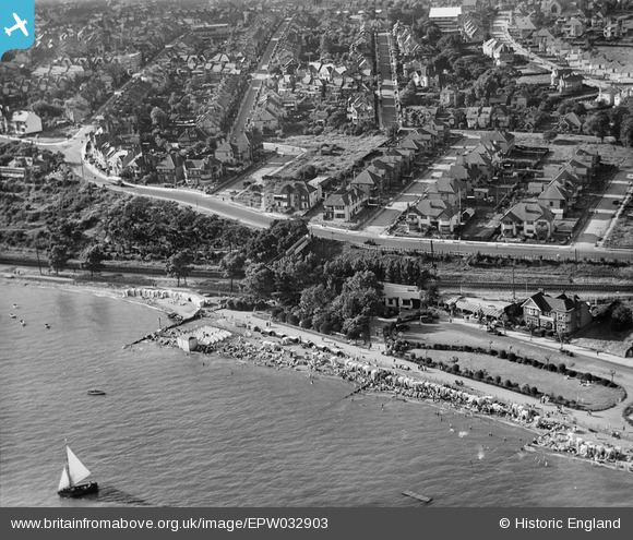
EPW032903 ENGLAND (1930). Chalkwell Station and The Ridgeway, Chalkwell, 1930
© Copyright OpenStreetMap contributors and licensed by the OpenStreetMap Foundation. 2024. Cartography is licensed as CC BY-SA.
Nearby Images (13)
EPW032903

EAW053102

EPW039867

EPW040971

EPW037005

EPW054669

EAW017024

EPW036997

EPW036714

EPW036706

EPW037010

EPW036985

EPW037000

Details
| Title | [EPW032903] Chalkwell Station and The Ridgeway, Chalkwell, 1930 |
| Reference | EPW032903 |
| Date | June-1930 |
| Link | |
| Place name | CHALKWELL |
| Parish | |
| District | |
| Country | ENGLAND |
| Easting / Northing | 585338, 185576 |
| Longitude / Latitude | 0.67279211050906, 51.538132174882 |
| National Grid Reference | TQ853856 |
Pins
Be the first to add a comment to this image!
User Comment Contributions
In 1930 the central clump of trees was the site of Chalkwell Station which was not built until 1933. |
 Qu1ckn1ck |
Friday 4th of December 2015 03:31:12 PM |


