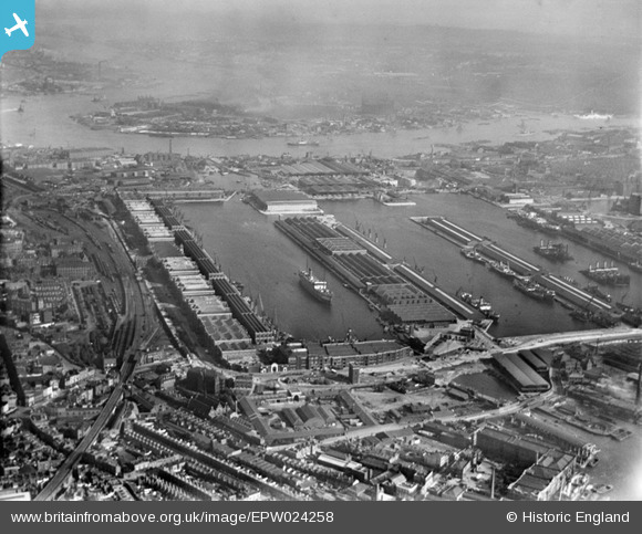
EPW024258 ENGLAND (1928). West India Dock, Poplar, 1928
© Copyright OpenStreetMap contributors and licensed by the OpenStreetMap Foundation. 2025. Cartography is licensed as CC BY-SA.
Nearby Images (9)
Details
| Title | [EPW024258] West India Dock, Poplar, 1928 |
| Reference | EPW024258 |
| Date | September-1928 |
| Link | |
| Place name | POPLAR |
| Parish | |
| District | |
| Country | ENGLAND |
| Easting / Northing | 537592, 180338 |
| Longitude / Latitude | -0.017286376183455, 51.504720131748 |
| National Grid Reference | TQ376803 |
Pins
 Chaz |
Friday 12th of January 2024 10:35:12 PM | |
 Kentishman |
Tuesday 9th of February 2021 10:53:52 AM | |
 Leslie B |
Friday 4th of March 2016 09:41:59 PM | |
 Leslie B |
Friday 4th of March 2016 09:35:31 PM | |
 EricLew_UK |
Friday 7th of December 2012 11:48:46 AM | |
 EricLew_UK |
Friday 7th of December 2012 11:47:58 AM | |
 EricLew_UK |
Friday 7th of December 2012 11:47:24 AM |


![[EPW024258] West India Dock, Poplar, 1928](http://britainfromabove.org.uk/sites/all/libraries/aerofilms-images/public/100x100/EPW/024/EPW024258.jpg)
![[EPW059926] West India Docks and environs, Canary Wharf, 1938](http://britainfromabove.org.uk/sites/all/libraries/aerofilms-images/public/100x100/EPW/059/EPW059926.jpg)
![[EPW005993] West India Dock (Import), Canary Wharf, 1921](http://britainfromabove.org.uk/sites/all/libraries/aerofilms-images/public/100x100/EPW/005/EPW005993.jpg)
![[EPW057061] West India Docks, Canary Wharf, 1938](http://britainfromabove.org.uk/sites/all/libraries/aerofilms-images/public/100x100/EPW/057/EPW057061.jpg)
![[EAW000648] The West India Dock, the South Dock and the Blackwall Reach, Poplar, 1946](http://britainfromabove.org.uk/sites/all/libraries/aerofilms-images/public/100x100/EAW/000/EAW000648.jpg)
![[EPW055310] West India Import and Export Docks and South Dock, Isle of Dogs, 1937](http://britainfromabove.org.uk/sites/all/libraries/aerofilms-images/public/100x100/EPW/055/EPW055310.jpg)
![[EPW059929] West India Docks and environs, Canary Wharf, 1938](http://britainfromabove.org.uk/sites/all/libraries/aerofilms-images/public/100x100/EPW/059/EPW059929.jpg)
![[EPW044127] West India and Millwall Docks, Isle of Dogs, from the north, 1934. This image has been produced from a copy-negative.](http://britainfromabove.org.uk/sites/all/libraries/aerofilms-images/public/100x100/EPW/044/EPW044127.jpg)
![[EAW029487] The East India Docks, Isle of Dogs, 1950](http://britainfromabove.org.uk/sites/all/libraries/aerofilms-images/public/100x100/EAW/029/EAW029487.jpg)