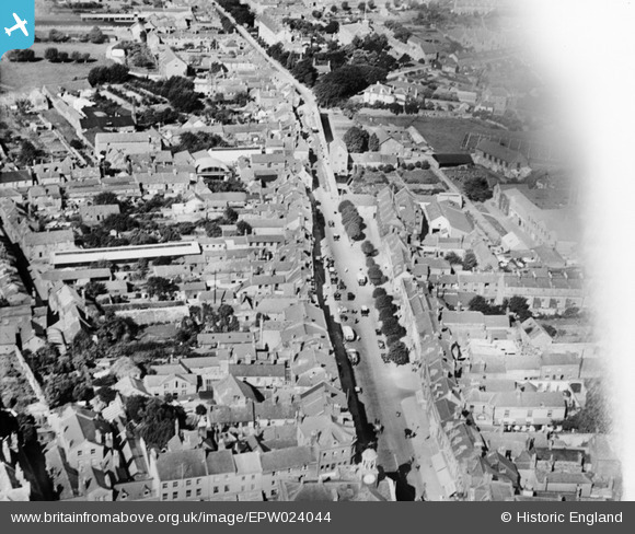
EPW024044 ENGLAND (1928). West Street, Bridport, 1928
© Copyright OpenStreetMap contributors and licensed by the OpenStreetMap Foundation. 2024. Cartography is licensed as CC BY-SA.
Nearby Images (16)
Details
| Title | [EPW024044] West Street, Bridport, 1928 |
| Reference | EPW024044 |
| Date | September-1928 |
| Link | |
| Place name | BRIDPORT |
| Parish | BRIDPORT |
| District | |
| Country | ENGLAND |
| Easting / Northing | 346433, 92972 |
| Longitude / Latitude | -2.7591274817274, 50.73331816472 |
| National Grid Reference | SY464930 |
Pins
 Amanda Best |
Tuesday 6th of June 2023 12:09:12 AM | |
 Alan McFaden |
Saturday 12th of April 2014 10:39:39 AM | |
 Alan McFaden |
Saturday 12th of April 2014 10:39:00 AM | |
 Alison Longman |
Thursday 19th of July 2012 10:10:33 PM | |
I don't think it is. Title is correct. It's West Street looking west. Your pin is just west of the North Street junction. |
 vof |
Friday 19th of October 2012 10:55:31 PM |
User Comment Contributions
The Town Hall 01/02/2014 |
 Class31 |
Monday 3rd of February 2014 10:10:19 AM |
The Ropemakers PH in West Street 01/02/2014 |
 Class31 |
Monday 3rd of February 2014 10:09:11 AM |
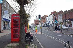
West Street looking west 01/02/2014 |
 Class31 |
Monday 3rd of February 2014 10:07:13 AM |
West Street looking west 01/02/2014 |
 Class31 |
Monday 3rd of February 2014 10:05:48 AM |


![[EPW024044] West Street, Bridport, 1928](http://britainfromabove.org.uk/sites/all/libraries/aerofilms-images/public/100x100/EPW/024/EPW024044.jpg)
![[EPW013518] The town centre, Bridport, 1925](http://britainfromabove.org.uk/sites/all/libraries/aerofilms-images/public/100x100/EPW/013/EPW013518.jpg)
![[EAW047109] Court Rope, Twine and Net Works, Bridport, 1952. This image was marked by Aerofilms Ltd for photo editing.](http://britainfromabove.org.uk/sites/all/libraries/aerofilms-images/public/100x100/EAW/047/EAW047109.jpg)
![[EAW047110] Court Rope, Twine and Net Works and environs, Bridport, 1952. This image was marked by Aerofilms Ltd for photo editing.](http://britainfromabove.org.uk/sites/all/libraries/aerofilms-images/public/100x100/EAW/047/EAW047110.jpg)
![[EAW047114] Court Rope, Twine and Net Works and environs, Bridport, 1952. This image was marked by Aerofilms Ltd for photo editing.](http://britainfromabove.org.uk/sites/all/libraries/aerofilms-images/public/100x100/EAW/047/EAW047114.jpg)
![[EPW013521] Court Mills, Bridport, 1925](http://britainfromabove.org.uk/sites/all/libraries/aerofilms-images/public/100x100/EPW/013/EPW013521.jpg)
![[EAW047112] Court Rope, Twine and Net Works, Bridport, 1952. This image was marked by Aerofilms Ltd for photo editing.](http://britainfromabove.org.uk/sites/all/libraries/aerofilms-images/public/100x100/EAW/047/EAW047112.jpg)
![[EAW047108] Court Rope, Twine and Net Works, Bridport, 1952. This image was marked by Aerofilms Ltd for photo editing.](http://britainfromabove.org.uk/sites/all/libraries/aerofilms-images/public/100x100/EAW/047/EAW047108.jpg)
![[EPW024042] The Town Hall, Bridport, 1928](http://britainfromabove.org.uk/sites/all/libraries/aerofilms-images/public/100x100/EPW/024/EPW024042.jpg)
![[EPW013517] The Town Hall and Market Place, Bridport, 1925](http://britainfromabove.org.uk/sites/all/libraries/aerofilms-images/public/100x100/EPW/013/EPW013517.jpg)
![[EPW024177] The Town Hall and environs, Bridport, 1928](http://britainfromabove.org.uk/sites/all/libraries/aerofilms-images/public/100x100/EPW/024/EPW024177.jpg)
![[EAW047111] Court Rope, Twine and Net Works, Bridport, 1952. This image was marked by Aerofilms Ltd for photo editing.](http://britainfromabove.org.uk/sites/all/libraries/aerofilms-images/public/100x100/EAW/047/EAW047111.jpg)
![[EPW024040] West Street and East Street, Bridport, 1928](http://britainfromabove.org.uk/sites/all/libraries/aerofilms-images/public/100x100/EPW/024/EPW024040.jpg)
![[EPW054829] South Street and the town, Bridport, 1937](http://britainfromabove.org.uk/sites/all/libraries/aerofilms-images/public/100x100/EPW/054/EPW054829.jpg)
![[EAW047113] Court Rope, Twine and Net Works and environs, Bridport, 1952. This image was marked by Aerofilms Ltd for photo editing.](http://britainfromabove.org.uk/sites/all/libraries/aerofilms-images/public/100x100/EAW/047/EAW047113.jpg)
![[EPW013519] The town centre, Bridport, 1925](http://britainfromabove.org.uk/sites/all/libraries/aerofilms-images/public/100x100/EPW/013/EPW013519.jpg)

