
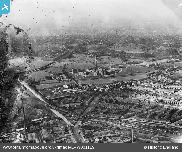
EPW001119 ENGLAND (1920). University of Birmingham, Edgbaston, from the south-west, 1920
© Copyright OpenStreetMap contributors and licensed by the OpenStreetMap Foundation. 2024. Cartography is licensed as CC BY-SA.
Nearby Images (2)
EPW001119

EPW022589

Details
| Title | [EPW001119] University of Birmingham, Edgbaston, from the south-west, 1920 |
| Reference | EPW001119 |
| Date | May-1920 |
| Link | |
| Place name | EDGBASTON |
| Parish | |
| District | |
| Country | ENGLAND |
| Easting / Northing | 404592, 283063 |
| Longitude / Latitude | -1.9324318299524, 52.445138356253 |
| National Grid Reference | SP046831 |
Pins
 Sarah68 |
Monday 21st of June 2021 04:46:14 PM | |
Paul |
Tuesday 27th of October 2020 02:28:30 PM | |
Griffin |
Monday 28th of September 2020 02:27:00 PM | |
Griffin |
Monday 28th of September 2020 02:12:00 PM | |
Griffin |
Monday 28th of September 2020 01:39:07 PM | |
Griffin |
Monday 28th of September 2020 01:22:07 PM | |
Griffin |
Monday 28th of September 2020 01:06:46 PM | |
 |
 navaho56 |
Wednesday 4th of September 2019 07:00:06 PM |
navaho56 |
Wednesday 4th of September 2019 06:53:24 PM | |
paulr |
Wednesday 4th of September 2019 05:32:44 PM | |
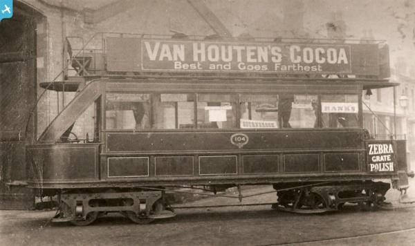
ON THE ORDINANCE SURVEY MAP OF 1884-1891, OPPOSITE DAWLISH ROAD ( BEFORE THE EXISTANCE OF GRANGE ROAD) SHOWS TRAM TRACKS LEADING TO A BUILDING BEHIND THE HOTEL (presumably the BOURNBROOK HOTEL) NAMED AS 'TRAMWAY STABLES', OBVIOUSLY FOR THE HORSE DRAWN TRAMS. |
Griffin |
Monday 28th of September 2020 02:23:22 PM |
john a |
Wednesday 11th of March 2015 11:38:29 PM | |
john a |
Wednesday 11th of March 2015 11:34:00 PM | |
HenryWRWhite |
Thursday 20th of December 2012 09:26:11 PM | |
HenryWRWhite |
Thursday 20th of December 2012 09:25:16 PM | |
HenryWRWhite |
Thursday 20th of December 2012 09:20:08 PM | |
HenryWRWhite |
Thursday 20th of December 2012 09:19:43 PM | |
birdseye? |
Monday 22nd of October 2012 12:22:37 PM | |
birdseye? |
Monday 22nd of October 2012 12:20:10 PM | |
birdseye? |
Monday 22nd of October 2012 12:15:18 PM | |
birdseye? |
Monday 22nd of October 2012 12:10:58 PM | |
Toby Clempson |
Thursday 11th of October 2012 05:05:07 PM | |
i lived on the stourbridge and netherton canal selly oak on reservoir road my back garden backed on to it.its sad its gone it use to join up to laple tunnel my dad swam that tunel when he was on leave from the navy in war time he drank at the stonehouse pub and now thats gone so sad. |
terry foster |
Wednesday 3rd of February 2016 12:42:19 AM |
Toby Clempson |
Thursday 11th of October 2012 05:03:43 PM | |
 Brasspot |
Thursday 28th of June 2012 07:24:15 AM | |
Brasspot |
Thursday 28th of June 2012 07:21:46 AM | |
Brasspot |
Wednesday 27th of June 2012 09:11:17 PM | |
Brasspot |
Wednesday 27th of June 2012 09:08:55 PM |

User Comment Contributions
i no selly oak well i was born there in harborne lane.i use to play as a boy on the canal.and hang out over at the university.the new qe hospital was allso my play ground.as i got older i would use the old battery site to ride my scambeler motor bike wish it was now.i would like to here from others who grew up in selly oak |
terry foster |
Wednesday 3rd of February 2016 12:35:13 AM |
 University of Birmingham, Edgbaston, 15/08/2015 |
 Class31 |
Wednesday 19th of August 2015 01:59:39 PM |
 The Ariel car works and the site of the later Patrick Motors works both appear in this photograph. |
Brasspot |
Wednesday 27th of June 2012 09:12:14 PM |
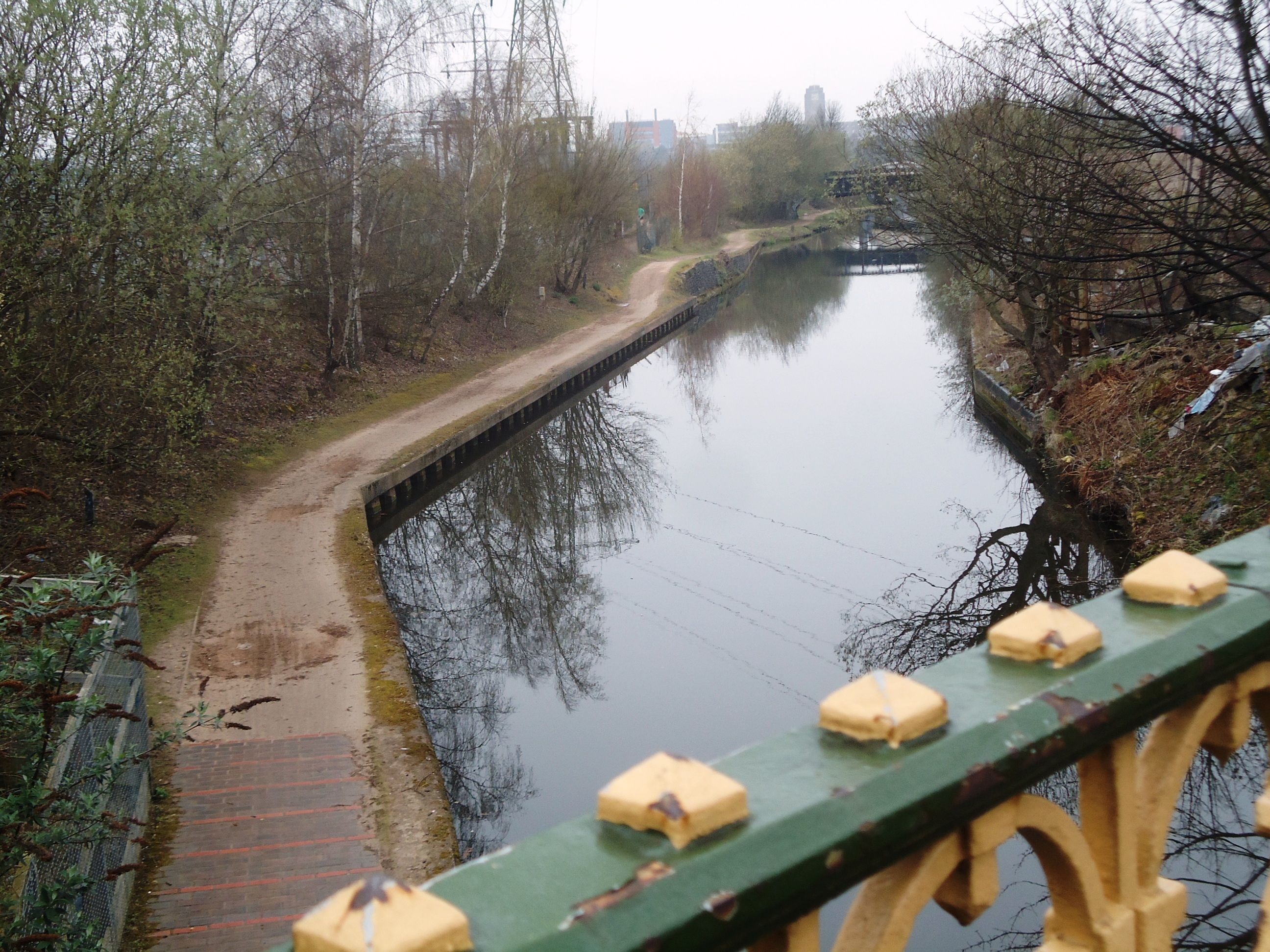 I hope place names added into comments enter the Gazetteer! We have Selly Oak (B29) in the foreground, Bournbrook to the right, and, in the background, Harborne (B17) left and Edgbaston (B19) right. Detailed study of the Harborne sector would show the house where we have lived since 1969 (built in the 1880s). Main transport links are the A38 (Bristol Road), the Lichfield-NewStreet-Redditch railway line (between the University and Selly Oak stations), and the Worcestershire and Birmingham Canal. The photo shows the canal, winter 2012, from the A38 bridge, looking northish (roughly towards the university). |
EricDeeson |
Tuesday 26th of June 2012 11:53:07 AM |