
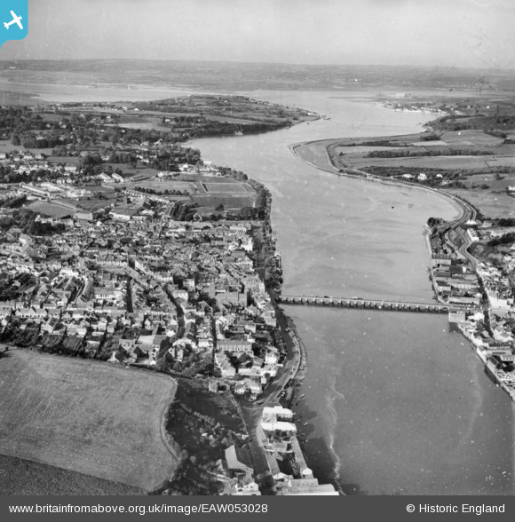
EAW053028 ENGLAND (1953). Bideford Bridge, the town and River Torridge, Bideford, from the south, 1953
© Copyright OpenStreetMap contributors and licensed by the OpenStreetMap Foundation. 2024. Cartography is licensed as CC BY-SA.
Nearby Images (8)
EAW053028

EPW039894

EAW007550

EPW033216

EPW033218

EAW031034

EPW059675

EPW039893

Details
| Title | [EAW053028] Bideford Bridge, the town and River Torridge, Bideford, from the south, 1953 |
| Reference | EAW053028 |
| Date | 19-November-1953 |
| Link | |
| Place name | BIDEFORD |
| Parish | BIDEFORD |
| District | |
| Country | ENGLAND |
| Easting / Northing | 245409, 126358 |
| Longitude / Latitude | -4.2041519798046, 51.015253243553 |
| National Grid Reference | SS454264 |
Pins
 Matt |
Friday 21st of September 2018 11:40:34 AM | |
gBr |
Thursday 15th of January 2015 03:12:21 AM | |
gBr |
Thursday 15th of January 2015 03:02:52 AM | |
gBr |
Thursday 15th of January 2015 03:00:35 AM | |
Was for the Bideford, Westward Ho! and Appledore railway. The railway opened 1901 to Northam and 1908 to Appledore. Last train ran March 1917 and locos were requisitioned by the Government. Never ran again - rolling stock and track were sold off soon after the end of WW1 and the track removed. The carriage shed is a remarkable survivor! |
John W |
Saturday 18th of July 2020 04:43:06 PM |
gBr |
Thursday 15th of January 2015 02:58:40 AM |