Scheduled Maintenance
This website will undergo scheduled maintenance on Tuesday, September 10th, between 11:00 and 15:00, as well as on Thursday, September 12th, between 10:00 and 12:00. During this time, services may be temporarily disrupted. We apologise for any inconvenience.
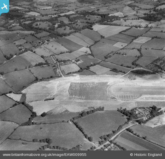
EAW009955 ENGLAND (1947). The western end of Bristol Filton Airport under construction, Catbrain, 1947
© Copyright OpenStreetMap contributors and licensed by the OpenStreetMap Foundation. 2024. Cartography is licensed as CC BY-SA.
Nearby Images (35)
Details
| Title | [EAW009955] The western end of Bristol Filton Airport under construction, Catbrain, 1947 |
| Reference | EAW009955 |
| Date | 3-September-1947 |
| Link | |
| Place name | CATBRAIN |
| Parish | ALMONDSBURY |
| District | |
| Country | ENGLAND |
| Easting / Northing | 357839, 180297 |
| Longitude / Latitude | -2.6077164242976, 51.51953574662 |
| National Grid Reference | ST578803 |
Pins
Be the first to add a comment to this image!


![[EAW009955] The western end of Bristol Filton Airport under construction, Catbrain, 1947](http://britainfromabove.org.uk/sites/all/libraries/aerofilms-images/public/100x100/EAW/009/EAW009955.jpg)
![[EAW009951] Bristol Filton Airport under construction and the surrounding countryside, Catbrain, from the west, 1947](http://britainfromabove.org.uk/sites/all/libraries/aerofilms-images/public/100x100/EAW/009/EAW009951.jpg)
![[EAW009952] Bristol Filton Airport under construction and the surrounding countryside, Catbrain, from the west, 1947](http://britainfromabove.org.uk/sites/all/libraries/aerofilms-images/public/100x100/EAW/009/EAW009952.jpg)
![[EAW004184] Bristol Filton Airport showing the main runway being extended, Catbrain, from the west, 1947](http://britainfromabove.org.uk/sites/all/libraries/aerofilms-images/public/100x100/EAW/004/EAW004184.jpg)
![[EAW003557] The Aeroplane Arrester under construction at Bristol Filton Airport, Catbrain, 1947](http://britainfromabove.org.uk/sites/all/libraries/aerofilms-images/public/100x100/EAW/003/EAW003557.jpg)
![[EAW001549] The village and the surrounding countryside, Catbrain, 1946](http://britainfromabove.org.uk/sites/all/libraries/aerofilms-images/public/100x100/EAW/001/EAW001549.jpg)
![[EAW003549] Bristol Filton Airport under construction, Catbrain, from the west, 1947](http://britainfromabove.org.uk/sites/all/libraries/aerofilms-images/public/100x100/EAW/003/EAW003549.jpg)
![[EAW027786] Bristol 167 Brabazon Mk1 G-AGPW on the runway at Bristol Filton Airport, Catbrain, from the west, 1949. This image was marked by Aerofilms Ltd for photo editing.](http://britainfromabove.org.uk/sites/all/libraries/aerofilms-images/public/100x100/EAW/027/EAW027786.jpg)
![[EAW009950] Bristol Filton Airport under construction, Catbrain, from the west, 1947](http://britainfromabove.org.uk/sites/all/libraries/aerofilms-images/public/100x100/EAW/009/EAW009950.jpg)
![[EAW027778] Bristol 167 Brabazon Mk1 G-AGPW on the runway at Bristol Filton Airport, Catbrain, from the west, 1949](http://britainfromabove.org.uk/sites/all/libraries/aerofilms-images/public/100x100/EAW/027/EAW027778.jpg)
![[EAW027775] Bristol 167 Brabazon Mk1 G-AGPW on the runway at Bristol Filton Airport, Catbrain, from the west, 1949. This image has been produced from a print.](http://britainfromabove.org.uk/sites/all/libraries/aerofilms-images/public/100x100/EAW/027/EAW027775.jpg)
![[EAW007138] Bristol Filton Airport under construction, Catbrain, from the west, 1947](http://britainfromabove.org.uk/sites/all/libraries/aerofilms-images/public/100x100/EAW/007/EAW007138.jpg)
![[EAW027780] Bristol 167 Brabazon Mk1 G-AGPW on the runway at Bristol Filton Airport, Catbrain, from the west, 1949](http://britainfromabove.org.uk/sites/all/libraries/aerofilms-images/public/100x100/EAW/027/EAW027780.jpg)
![[EAW027773] Bristol 167 Brabazon Mk1 G-AGPW on the runway at Bristol Filton Airport, Catbrain, from the north-west, 1949. This image has been produced from a print.](http://britainfromabove.org.uk/sites/all/libraries/aerofilms-images/public/100x100/EAW/027/EAW027773.jpg)
![[EAW007136] Bristol Filton Airport under construction, Catbrain, from the west, 1947](http://britainfromabove.org.uk/sites/all/libraries/aerofilms-images/public/100x100/EAW/007/EAW007136.jpg)
![[EAW027785] Bristol 167 Brabazon Mk1 G-AGPW on the runway at Bristol Filton Airport, Catbrain, from the west, 1949](http://britainfromabove.org.uk/sites/all/libraries/aerofilms-images/public/100x100/EAW/027/EAW027785.jpg)
![[EAW027776] Bristol 167 Brabazon Mk1 G-AGPW on the runway at Bristol Filton Airport, Catbrain, from the west, 1949. This image has been produced from a print.](http://britainfromabove.org.uk/sites/all/libraries/aerofilms-images/public/100x100/EAW/027/EAW027776.jpg)
![[EAW027774] Bristol 167 Brabazon Mk1 G-AGPW on the runway at Bristol Filton Airport, Catbrain, from the west, 1949. This image has been produced from a print marked by Aerofilms Ltd for photo editing.](http://britainfromabove.org.uk/sites/all/libraries/aerofilms-images/public/100x100/EAW/027/EAW027774.jpg)
![[EAW009953] The western end of Bristol Filton Airport under construction, Catbrain, 1947](http://britainfromabove.org.uk/sites/all/libraries/aerofilms-images/public/100x100/EAW/009/EAW009953.jpg)
![[EAW013922] Bristol Filton Airport, Catbrain, from the west, 1948. This image has been produced from a print.](http://britainfromabove.org.uk/sites/all/libraries/aerofilms-images/public/100x100/EAW/013/EAW013922.jpg)
![[EAW007145] Bristol Filton Airport under construction, Catbrain, from the west, 1947](http://britainfromabove.org.uk/sites/all/libraries/aerofilms-images/public/100x100/EAW/007/EAW007145.jpg)
![[EAW027787] Bristol 167 Brabazon Mk1 G-AGPW on the runway at Bristol Filton Airport, Catbrain, 1949. This image was marked by Aerofilms Ltd for photo editing.](http://britainfromabove.org.uk/sites/all/libraries/aerofilms-images/public/100x100/EAW/027/EAW027787.jpg)
![[EAW004182] The western end of the main runway of Bristol Filton Airport under construction, Catbrain, 1947](http://britainfromabove.org.uk/sites/all/libraries/aerofilms-images/public/100x100/EAW/004/EAW004182.jpg)
![[EAW004181] Bristol Filton Airport showing the main runway being extended, Catbrain, from the west, 1947](http://britainfromabove.org.uk/sites/all/libraries/aerofilms-images/public/100x100/EAW/004/EAW004181.jpg)
![[EAW012432] Bristol Filton Airport under construction, Catbrain, from the west, 1947](http://britainfromabove.org.uk/sites/all/libraries/aerofilms-images/public/100x100/EAW/012/EAW012432.jpg)
![[EAW027777] Bristol 167 Brabazon Mk1 G-AGPW on the runway at Bristol Filton Airport, Catbrain, from the south-west, 1949. This image has been produced from a print.](http://britainfromabove.org.uk/sites/all/libraries/aerofilms-images/public/100x100/EAW/027/EAW027777.jpg)
![[EAW027781] Bristol 167 Brabazon Mk1 G-AGPW on the runway at Bristol Filton Airport, Catbrain, 1949. This image was marked by Aerofilms Ltd for photo editing.](http://britainfromabove.org.uk/sites/all/libraries/aerofilms-images/public/100x100/EAW/027/EAW027781.jpg)
![[EAW027783] Bristol 167 Brabazon Mk1 G-AGPW on the runway at Bristol Filton Airport, Catbrain, from the west, 1949](http://britainfromabove.org.uk/sites/all/libraries/aerofilms-images/public/100x100/EAW/027/EAW027783.jpg)
![[EAW003548] Bristol Filton Airport under construction, Catbrain, from the west, 1947](http://britainfromabove.org.uk/sites/all/libraries/aerofilms-images/public/100x100/EAW/003/EAW003548.jpg)
![[EAW004180] Bristol Filton Airport showing the main runway being extended, Catbrain, from the north-west, 1947](http://britainfromabove.org.uk/sites/all/libraries/aerofilms-images/public/100x100/EAW/004/EAW004180.jpg)
![[EAW001555] Housing at The Close, Charlton Common and Bristol Filton Airport in the distance, Catbrain, 1946](http://britainfromabove.org.uk/sites/all/libraries/aerofilms-images/public/100x100/EAW/001/EAW001555.jpg)
![[EAW007131] Bristol Filton Airport under construction, Catbrain, from the west, 1947](http://britainfromabove.org.uk/sites/all/libraries/aerofilms-images/public/100x100/EAW/007/EAW007131.jpg)
![[EAW001552] Housing at The Close, Charlton Common and the surrounding countryside, Catbrain, 1946](http://britainfromabove.org.uk/sites/all/libraries/aerofilms-images/public/100x100/EAW/001/EAW001552.jpg)
![[EAW004183] The western end of the main runway of Bristol Filton Airport under construction, Catbrain, 1947](http://britainfromabove.org.uk/sites/all/libraries/aerofilms-images/public/100x100/EAW/004/EAW004183.jpg)
![[EAW027784] Bristol 167 Brabazon Mk1 G-AGPW on the runway at Bristol Filton Airport, Catbrain, from the north-west, 1949. This image was marked by Aerofilms Ltd for photo editing.](http://britainfromabove.org.uk/sites/all/libraries/aerofilms-images/public/100x100/EAW/027/EAW027784.jpg)