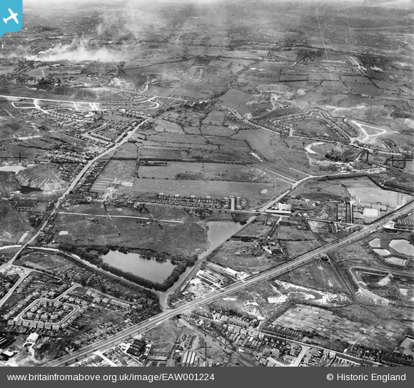
EAW001224 ENGLAND (1946). Titford Pool, housing at Borough Crescent and the surrounding area, Oldbury, 1946
© Copyright OpenStreetMap contributors and licensed by the OpenStreetMap Foundation. 2024. Cartography is licensed as CC BY-SA.
Nearby Images (5)
Details
| Title | [EAW001224] Titford Pool, housing at Borough Crescent and the surrounding area, Oldbury, 1946 |
| Reference | EAW001224 |
| Date | 24-June-1946 |
| Link | |
| Place name | OLDBURY |
| Parish | |
| District | |
| Country | ENGLAND |
| Easting / Northing | 398159, 288148 |
| Longitude / Latitude | -2.0271171591085, 52.490873915434 |
| National Grid Reference | SO982881 |
Pins
 Matt Aldred edob.mattaldred.com |
Sunday 28th of February 2021 09:27:12 AM | |
 Matt Aldred edob.mattaldred.com |
Sunday 28th of February 2021 09:26:47 AM | |
 Mr |
Monday 9th of September 2019 11:58:18 PM | |
 Mr |
Monday 9th of September 2019 11:56:43 PM | |
 Mr |
Monday 9th of September 2019 11:55:48 PM | |
 Mr |
Monday 9th of September 2019 11:53:54 PM | |
 Mr |
Monday 9th of September 2019 11:49:31 PM | |
 Sparky |
Thursday 16th of November 2017 09:49:37 PM | |
 Sparky |
Thursday 16th of November 2017 09:49:02 PM | |
 Sparky |
Thursday 16th of November 2017 09:47:14 PM | |
 keithbeckett51@gmail.com |
Thursday 26th of March 2015 12:52:20 PM | |
 Martin |
Tuesday 21st of October 2014 10:52:07 PM | |
 Martin |
Tuesday 21st of October 2014 10:48:09 PM | |
 Martin |
Tuesday 21st of October 2014 10:47:42 PM | |
 Martin |
Tuesday 21st of October 2014 10:45:27 PM | |
 Martin |
Tuesday 21st of October 2014 10:44:04 PM | |
 Martin |
Tuesday 21st of October 2014 10:43:02 PM | |
 Martin |
Tuesday 21st of October 2014 10:41:48 PM | |
 Martin |
Tuesday 21st of October 2014 10:40:36 PM | |
 Stormy78 |
Friday 25th of July 2014 01:22:09 PM | |
 Stormy78 |
Friday 25th of July 2014 01:14:59 PM |


![[EAW001224] Titford Pool, housing at Borough Crescent and the surrounding area, Oldbury, 1946](http://britainfromabove.org.uk/sites/all/libraries/aerofilms-images/public/100x100/EAW/001/EAW001224.jpg)
![[EAW001223] Titford Pool, housing at Borough Crescent and the Blue Rock Quarries, Oldbury, 1946](http://britainfromabove.org.uk/sites/all/libraries/aerofilms-images/public/100x100/EAW/001/EAW001223.jpg)
![[EAW001221] Titford Pool, housing at Borough Crescent and the Blue Rock Quarries, Oldbury, 1946](http://britainfromabove.org.uk/sites/all/libraries/aerofilms-images/public/100x100/EAW/001/EAW001221.jpg)
![[EAW001222] Titford Pool, housing at Borough Crescent and the Blue Rock Quarries, Oldbury, 1946](http://britainfromabove.org.uk/sites/all/libraries/aerofilms-images/public/100x100/EAW/001/EAW001222.jpg)
![[EAW001225] Wolverhampton Road, housing at Borough Crescent and the surrounding area, Oldbury, 1946](http://britainfromabove.org.uk/sites/all/libraries/aerofilms-images/public/100x100/EAW/001/EAW001225.jpg)