
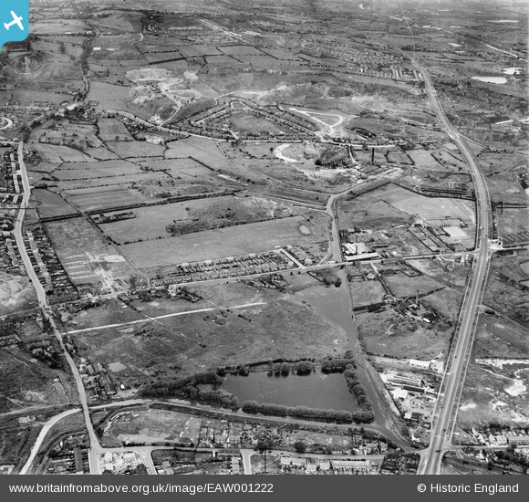
EAW001222 ENGLAND (1946). Titford Pool, housing at Borough Crescent and the Blue Rock Quarries, Oldbury, 1946
© Copyright OpenStreetMap contributors and licensed by the OpenStreetMap Foundation. 2024. Cartography is licensed as CC BY-SA.
Nearby Images (5)
EAW001222

EAW001221

EAW001223

EAW001224

EAW001225

Details
| Title | [EAW001222] Titford Pool, housing at Borough Crescent and the Blue Rock Quarries, Oldbury, 1946 |
| Reference | EAW001222 |
| Date | 24-June-1946 |
| Link | |
| Place name | OLDBURY |
| Parish | |
| District | |
| Country | ENGLAND |
| Easting / Northing | 398232, 288178 |
| Longitude / Latitude | -2.0260420591224, 52.491143886661 |
| National Grid Reference | SO982882 |
Pins
 Alan |
Saturday 11th of May 2024 03:02:41 PM | |
PJ |
Thursday 11th of May 2023 06:32:32 PM | |
 Matt Aldred edob.mattaldred.com |
Thursday 27th of January 2022 03:21:35 PM | |
Sparky |
Friday 17th of November 2017 08:28:02 AM | |
Sparky |
Friday 17th of November 2017 08:27:39 AM | |
Sparky |
Thursday 16th of November 2017 09:54:38 PM | |
Stormy78 |
Friday 25th of July 2014 01:25:17 PM | |
Stormy78 |
Friday 25th of July 2014 01:24:44 PM | |
Martin |
Thursday 16th of January 2014 01:08:37 AM |