
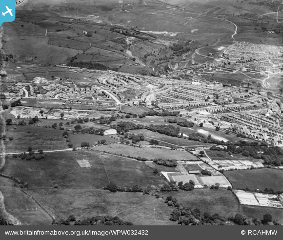
WPW032432 WALES (1930). General view of Aberbargoed, oblique aerial view. 5"x4" black and white glass plate negative.
© Hawlfraint cyfranwyr OpenStreetMap a thrwyddedwyd gan yr OpenStreetMap Foundation. 2024. Trwyddedir y gartograffeg fel CC BY-SA.
Delweddau cyfagos (5)
WPW032399

WPW032432

WPW032433

WPW032434

WPW032398

Manylion
| Pennawd | [WPW032432] General view of Aberbargoed, oblique aerial view. 5"x4" black and white glass plate negative. |
| Cyfeirnod | WPW032432 |
| Dyddiad | 1930 |
| Dolen | Coflein Archive Item 6370749 |
| Enw lle | |
| Plwyf | |
| Ardal | |
| Gwlad | WALES |
| Dwyreiniad / Gogleddiad | 315530, 200040 |
| Hydred / Lledred | -3.2222119190704, 51.692287916409 |
| Cyfeirnod Grid Cenedlaethol | SO155000 |
Pinnau
 Dave Lewis |
Saturday 25th of May 2013 12:50:13 PM | |
Dave Lewis |
Saturday 25th of May 2013 12:49:09 PM | |
Dave Lewis |
Saturday 25th of May 2013 12:48:26 PM | |
Dave Lewis |
Saturday 25th of May 2013 12:47:45 PM | |
Dave Lewis |
Saturday 25th of May 2013 12:46:53 PM | |
Dave Lewis |
Saturday 25th of May 2013 12:46:21 PM | |
Dave Lewis |
Saturday 25th of May 2013 12:45:25 PM | |
Dave Lewis |
Saturday 25th of May 2013 12:44:45 PM | |
Dave Lewis |
Saturday 25th of May 2013 12:44:00 PM | |
Dave Lewis |
Saturday 25th of May 2013 12:43:12 PM | |
Dave Lewis |
Saturday 25th of May 2013 12:42:40 PM | |
Dave Lewis |
Saturday 25th of May 2013 12:42:06 PM | |
Dave Lewis |
Saturday 25th of May 2013 12:40:59 PM |
Cyfraniadau Grŵp
Bargoed is in the middle distance with Aberbargoed in the distance to the right of shot. |
 Class31 |
Thursday 28th of June 2012 09:55:10 AM |


