
EPW038821 ENGLAND (1932). Earthworks in Wennington Park, Wennington, 1932

© Hawlfraint cyfranwyr OpenStreetMap a thrwyddedwyd gan yr OpenStreetMap Foundation. 2024. Trwyddedir y gartograffeg fel CC BY-SA.
Delweddau cyfagos (3)
EPW038821

EPW038823

EPW038822

Manylion
| Pennawd | [EPW038821] Earthworks in Wennington Park, Wennington, 1932 |
| Cyfeirnod | EPW038821 |
| Dyddiad | 30-June-1932 |
| Dolen | |
| Enw lle | WENNINGTON |
| Plwyf | WENNINGTON |
| Ardal | |
| Gwlad | ENGLAND |
| Dwyreiniad / Gogleddiad | 361754, 470492 |
| Hydred / Lledred | -2.5853332474148, 54.128680911933 |
| Cyfeirnod Grid Cenedlaethol | SD618705 |
Pinnau
 Maurice |
Sunday 20th of January 2013 08:59:26 AM | |
Maurice |
Sunday 20th of January 2013 08:58:30 AM | |
 Derekdye |
Sunday 13th of January 2013 06:19:16 PM | |
 BigglesH |
Sunday 16th of December 2012 02:36:48 PM |
Cyfraniadau Grŵp
Wennington Hall, Lancs. A faint boundary bank passing across the earthwork was not on contemporary maps, but is now re-established. Unfortunately the earthwork does not appear on any map edition that I have seen. However, the location is established unambiguously by the structure of the nearby walled garden, with a D-shaped extension on the southern wall. A glasshouse is seen within this in the picture, and is shown in the contemporary (1913 & 1894) 1:2500 OS maps. |
 Dylan Moore |
Sunday 10th of March 2013 09:34:08 PM |
Hi Dylan, Great spot! Thank you, this and the two other images of the earthwork are really tricky so it's great to have them identified. The original Aerofilms Ltd Register entry is "Wellington". Close, but not close enough, to the actual place name! We'll update the catalogue entry, and post the new data here in due course. Yours, Katy Britain from Above Cataloguing Team Leader |
Katy Whitaker |
Friday 8th of March 2013 03:20:30 PM |
Interestingly, this appears to be a different circular feature to that in EPW038822, though both are in fields around Wennington Hall School. I cannot see evidence of the feature in EPW038822 on Google Maps. |
David Parry |
Sunday 10th of March 2013 09:34:08 PM |
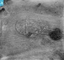 Wennington, Lancashire. As added by Rebecca, now with the photo linked. I'm not sure of the extent of the grounds of Wennington Hall School, but this feature is probably within them. |
David Parry |
Sunday 10th of March 2013 07:07:12 PM |
It seems to be shown on the 6 inch First Edition OS map - only looking online at low resolution as I write, but there is a circle enclosing trees and possibly another symbol - will need to look at a clearer version of the map. |
David Parry |
Sunday 10th of March 2013 07:07:12 PM |
Can be seen quite clearly on Google maps. https://maps.google.com/?ll=54.129329,-2.586105&spn=0.001165,0.002411&t=h&z=19 |
 Richard |
Sunday 10th of March 2013 06:24:43 PM |
Also visible in Google Maps Street View from Spout Lane to the east. I wonder if the feature might be somewhat more recent than prehistoric? |
David Parry |
Sunday 10th of March 2013 06:24:43 PM |
Appears to be a different angle of Photo EPW038823. |
TheBlueCube |
Wednesday 23rd of January 2013 07:35:17 PM |
Looks like a henge monument or a causewayed enclosure (both Neolithic monuments in date). If it is, it should be easy enough to identify with the ridge and furrow respecting it and the later earthwork bisecting it. |
Rebecca |
Wednesday 9th of January 2013 10:48:08 AM |
Could this be an Iron Age Hill Fort ? Judging by the furrows around the circle, it would seem the farmer had left it alone. |
BigglesH |
Sunday 16th of December 2012 02:53:41 PM |
Don't know location but this is same as EPW038823 - note the ridge and position of solitary shrub and nearby tree. |
 Mike Dean |
Wednesday 12th of December 2012 10:37:13 PM |


