
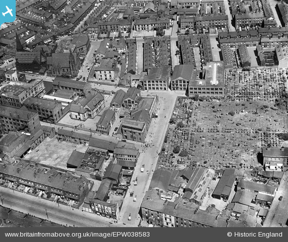
EPW038583 ENGLAND (1932). The Atlas Ink Works, the Ardwick Cemetery and environs, Ardwick, 1932
© Hawlfraint cyfranwyr OpenStreetMap a thrwyddedwyd gan yr OpenStreetMap Foundation. 2024. Trwyddedir y gartograffeg fel CC BY-SA.
Delweddau cyfagos (6)
EPW038583

EPW038585

EPW038586

EPW038584

EPW038582

EPW038587

Manylion
| Pennawd | [EPW038583] The Atlas Ink Works, the Ardwick Cemetery and environs, Ardwick, 1932 |
| Cyfeirnod | EPW038583 |
| Dyddiad | June-1932 |
| Dolen | |
| Enw lle | ARDWICK |
| Plwyf | |
| Ardal | |
| Gwlad | ENGLAND |
| Dwyreiniad / Gogleddiad | 385555, 397104 |
| Hydred / Lledred | -2.2176351909593, 53.470220248383 |
| Cyfeirnod Grid Cenedlaethol | SJ856971 |
Pinnau
 JJH |
Thursday 25th of August 2016 10:15:54 PM | |
JJH |
Thursday 25th of August 2016 10:15:14 PM | |
JJH |
Thursday 25th of August 2016 10:14:01 PM | |
JJH |
Thursday 25th of August 2016 10:13:13 PM | |
JJH |
Thursday 25th of August 2016 10:12:45 PM | |
JJH |
Thursday 25th of August 2016 10:10:27 PM | |
JJH |
Thursday 25th of August 2016 10:09:59 PM | |
JJH |
Thursday 25th of August 2016 10:08:13 PM | |
JJH |
Thursday 25th of August 2016 10:07:26 PM | |
JJH |
Thursday 25th of August 2016 10:07:08 PM | |
JJH |
Thursday 25th of August 2016 10:06:42 PM | |
JJH |
Thursday 25th of August 2016 10:06:17 PM | |
JJH |
Thursday 25th of August 2016 10:06:02 PM | |
JJH |
Thursday 25th of August 2016 10:05:39 PM | |
JJH |
Thursday 25th of August 2016 10:05:24 PM |
Cyfraniadau Grŵp
Higher Ardwick: Lived here at No 61 in the 50s and 60s. Interesting to look at a picture of the place taken in 1932. |
peter |
Thursday 7th of April 2016 12:25:22 AM |


