
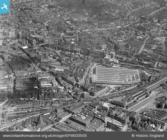
EPW033505 ENGLAND (1930). Bristol Temple Meads Goods Depot and environs, Bristol, 1930
© Hawlfraint cyfranwyr OpenStreetMap a thrwyddedwyd gan yr OpenStreetMap Foundation. 2024. Trwyddedir y gartograffeg fel CC BY-SA.
Delweddau cyfagos (5)
EPW033505

EPW034457

EPW034453

EPW034459
 and the Tramway Generating Station, Bristol, 1930")
EPW034454
 and the Tramway Generating Station, Bristol, 1930")
Manylion
| Pennawd | [EPW033505] Bristol Temple Meads Goods Depot and environs, Bristol, 1930 |
| Cyfeirnod | EPW033505 |
| Dyddiad | July-1930 |
| Dolen | |
| Enw lle | BRISTOL |
| Plwyf | |
| Ardal | |
| Gwlad | ENGLAND |
| Dwyreiniad / Gogleddiad | 359465, 172682 |
| Hydred / Lledred | -2.5834058050736, 51.451180256527 |
| Cyfeirnod Grid Cenedlaethol | ST595727 |
Pinnau
 MB |
Monday 18th of July 2016 09:11:00 PM | |
MB |
Monday 18th of July 2016 09:09:51 PM | |
MB |
Monday 18th of July 2016 09:08:46 PM | |
Mariateresa |
Friday 13th of December 2013 11:30:21 PM | |
Mariateresa |
Friday 13th of December 2013 11:29:31 PM | |
Mariateresa |
Friday 13th of December 2013 10:40:01 PM | |
Tiny Tim |
Thursday 18th of July 2013 01:21:55 PM | |
adfbristol |
Monday 15th of July 2013 10:33:08 PM | |
adfbristol |
Monday 15th of July 2013 10:31:24 PM | |
 Class31 |
Monday 10th of June 2013 09:04:40 PM | |
Andy Hill |
Monday 18th of March 2013 11:36:47 PM | |
Class31 |
Wednesday 6th of February 2013 03:36:38 PM | |
Class31 |
Wednesday 6th of February 2013 03:28:41 PM | |
Class31 |
Wednesday 6th of February 2013 03:27:58 PM | |
Class31 |
Wednesday 6th of February 2013 03:27:34 PM |


