
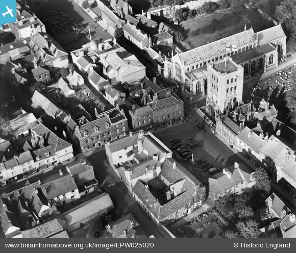
EPW025020 ENGLAND (1928). Chequer Square and St James' Cathedral, Bury St Edmunds, 1928
© Hawlfraint cyfranwyr OpenStreetMap a thrwyddedwyd gan yr OpenStreetMap Foundation. 2024. Trwyddedir y gartograffeg fel CC BY-SA.
Delweddau cyfagos (16)
EPW025020

EPW025022

EPW025023

EAW024397

EAW024395

EPW025021

EPW025024

EAW024398

EPW001753

EAW029742

EPW001752

EAW024396

EPW001773

EPW001750

EAW029744

EPW001749

Manylion
| Pennawd | [EPW025020] Chequer Square and St James' Cathedral, Bury St Edmunds, 1928 |
| Cyfeirnod | EPW025020 |
| Dyddiad | 9-October-1928 |
| Dolen | |
| Enw lle | BURY ST EDMUNDS |
| Plwyf | BURY ST. EDMUNDS |
| Ardal | |
| Gwlad | ENGLAND |
| Dwyreiniad / Gogleddiad | 585535, 264078 |
| Hydred / Lledred | 0.7178643583867, 52.243167803658 |
| Cyfeirnod Grid Cenedlaethol | TL855641 |
Pinnau
 MorrisDancer |
Monday 30th of September 2013 11:16:47 PM | |
MorrisDancer |
Thursday 5th of September 2013 10:32:21 PM | |
MorrisDancer |
Thursday 5th of September 2013 10:31:21 PM | |
MorrisDancer |
Thursday 5th of September 2013 10:29:47 PM | |
MorrisDancer |
Thursday 5th of September 2013 10:29:13 PM | |
Debz |
Saturday 27th of October 2012 01:08:37 PM |


