
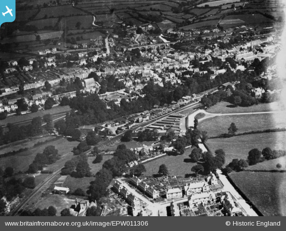
EPW011306 ENGLAND (1924). The Cattle Market and environs, Tavistock, 1924. This image has been produced from a copy-negative.
© Hawlfraint cyfranwyr OpenStreetMap a thrwyddedwyd gan yr OpenStreetMap Foundation. 2024. Trwyddedir y gartograffeg fel CC BY-SA.
Delweddau cyfagos (3)
EPW011306

EPW023606

EPW011304

Manylion
| Pennawd | [EPW011306] The Cattle Market and environs, Tavistock, 1924. This image has been produced from a copy-negative. |
| Cyfeirnod | EPW011306 |
| Dyddiad | July-1924 |
| Dolen | |
| Enw lle | TAVISTOCK |
| Plwyf | TAVISTOCK |
| Ardal | |
| Gwlad | ENGLAND |
| Dwyreiniad / Gogleddiad | 248051, 74108 |
| Hydred / Lledred | -4.1449108928498, 50.546374051638 |
| Cyfeirnod Grid Cenedlaethol | SX481741 |
Pinnau
Cyfraniadau Grŵp
Tavistock at one time had two railway stations - The GWR one (renamed Tavistock South in 1948) closed in 1962 and the L&SWR one (renamed Tavistock North in 1948) closed in 1968. This area is now devoid of railways. Following the damage by storms to the South Devon coast line in 2014, suggestions have been made that the LSWR line should be reopened as a safer inland route. |
 John W |
Friday 30th of September 2016 06:05:54 PM |


