
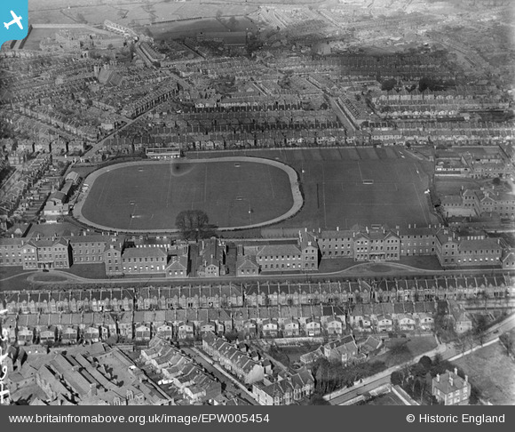
EPW005454 ENGLAND (1921). The County Ground at Ashley Down, Bristol, 1921
© Hawlfraint cyfranwyr OpenStreetMap a thrwyddedwyd gan yr OpenStreetMap Foundation. 2024. Trwyddedir y gartograffeg fel CC BY-SA.
Delweddau cyfagos (5)
EPW005454

EPW005455

EPW005457

EPW005456

EPW005453

Manylion
| Pennawd | [EPW005454] The County Ground at Ashley Down, Bristol, 1921 |
| Cyfeirnod | EPW005454 |
| Dyddiad | 20-March-1921 |
| Dolen | |
| Enw lle | ASHLEY DOWN |
| Plwyf | |
| Ardal | |
| Gwlad | ENGLAND |
| Dwyreiniad / Gogleddiad | 359594, 175517 |
| Hydred / Lledred | -2.581873385569, 51.476682078921 |
| Cyfeirnod Grid Cenedlaethol | ST596755 |
Pinnau
 arkatee |
Saturday 7th of January 2017 10:06:15 PM | |
NicTomkins |
Thursday 24th of July 2014 06:20:15 PM | |
NicTomkins |
Thursday 24th of July 2014 06:19:38 PM | |
 Class31 |
Thursday 31st of January 2013 11:48:15 PM | |
Class31 |
Thursday 31st of January 2013 11:46:19 PM | |
Class31 |
Thursday 31st of January 2013 11:35:47 PM | |
Class31 |
Thursday 31st of January 2013 11:33:27 PM | |
Class31 |
Thursday 31st of January 2013 11:29:58 PM | |
Class31 |
Thursday 31st of January 2013 11:23:44 PM | |
Class31 |
Thursday 31st of January 2013 11:22:13 PM | |
Class31 |
Thursday 31st of January 2013 11:20:19 PM | |
 John Swain |
Friday 17th of August 2012 08:36:42 AM | |
John Swain |
Friday 17th of August 2012 08:34:06 AM |
Cyfraniadau Grŵp
A view looking north-west towards the expanding Bristolian suburbs of Bishopston (left) and Horfield (right), across the expanse of the County Cricket Ground at Ashley Down and Muller's Orphanage, which runs the full length of the pitches in the middle distance, parallel to Sefton Park Road. |
John Swain |
Friday 17th of August 2012 08:33:15 AM |


