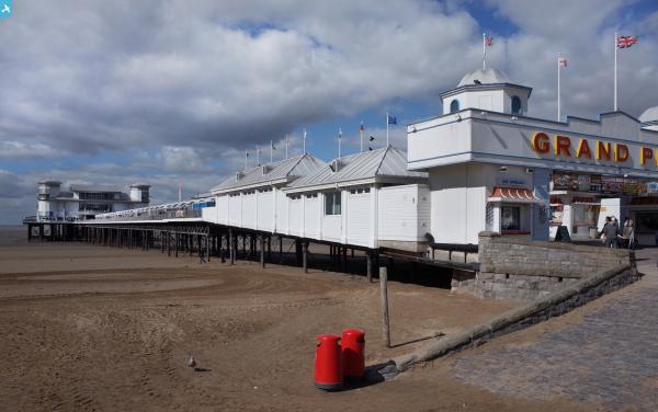
EPW001032 ENGLAND (1920). View over Weston-Super-Mare and the Grand Pier, Weston-Super-Mare, from the north-west, 1920

© Hawlfraint cyfranwyr OpenStreetMap a thrwyddedwyd gan yr OpenStreetMap Foundation. 2024. Trwyddedir y gartograffeg fel CC BY-SA.
Delweddau cyfagos (5)
EPW001032

EPW048450

EPW024073

EPW048453

EPW048451

Manylion
| Pennawd | [EPW001032] View over Weston-Super-Mare and the Grand Pier, Weston-Super-Mare, from the north-west, 1920 |
| Cyfeirnod | EPW001032 |
| Dyddiad | May-1920 |
| Dolen | |
| Enw lle | WESTON-SUPER-MARE |
| Plwyf | WESTON-SUPER-MARE |
| Ardal | |
| Gwlad | ENGLAND |
| Dwyreiniad / Gogleddiad | 331139, 161601 |
| Hydred / Lledred | -2.9888888094833, 51.348810448583 |
| Cyfeirnod Grid Cenedlaethol | ST311616 |
Pinnau
 gBr |
Friday 12th of March 2021 09:49:26 PM | |
John W |
Thursday 16th of July 2020 08:04:44 PM | |
 Alan McFaden |
Saturday 19th of October 2013 02:37:38 PM | |
Alan McFaden |
Saturday 19th of October 2013 02:36:29 PM | |
Alan McFaden |
Saturday 19th of October 2013 02:35:26 PM | |
MB |
Tuesday 11th of September 2012 06:54:06 PM | |
Interestingly this extension, according to https://piers.org.uk/pier/weston-super-mare-grand-pier/ was demolished between 1916-18! |
John W |
Thursday 16th of July 2020 08:07:44 PM |