
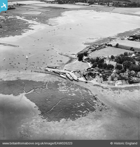
EAW026223 ENGLAND (1949). Bosham Quay and the village, Bosham, 1949
© Hawlfraint cyfranwyr OpenStreetMap a thrwyddedwyd gan yr OpenStreetMap Foundation. 2024. Trwyddedir y gartograffeg fel CC BY-SA.
Delweddau cyfagos (4)
EAW026223

EAW026224

EAW026219

EAW026221

Manylion
| Pennawd | [EAW026223] Bosham Quay and the village, Bosham, 1949 |
| Cyfeirnod | EAW026223 |
| Dyddiad | 12-August-1949 |
| Dolen | |
| Enw lle | BOSHAM |
| Plwyf | BOSHAM |
| Ardal | |
| Gwlad | ENGLAND |
| Dwyreiniad / Gogleddiad | 480349, 103808 |
| Hydred / Lledred | -0.85902791946745, 50.827665593444 |
| Cyfeirnod Grid Cenedlaethol | SU803038 |
Pinnau
 ken |
Sunday 14th of June 2015 04:32:01 PM | |
MB |
Tuesday 18th of March 2014 11:30:30 PM | |
MB |
Tuesday 18th of March 2014 11:27:08 PM | |
MB |
Tuesday 18th of March 2014 11:26:02 PM | |
Now the Bosham Sailing Club. It was a tide mill, with a millpond beyond, out of shot. Millers would have had to work according to the tides. Details of the Grade II Listed structure here: http://list.english-heritage.org.uk/resultsingle.aspx?uid=1026429&searchtype=mapsearch |
MB |
Tuesday 18th of March 2014 11:39:04 PM |
Rob Farrow's photograph of the former tide mill and millpond, taken in 2013, can be seen on the Geograph site - http://www.geograph.org.uk/photo/3541423 |
MB |
Tuesday 18th of March 2014 11:42:08 PM |
Cyfraniadau Grŵp
Bosham was a medieval port within Chichester Harbour. Local industries included brickmaking, boatbuilding, fishing and also oyster fishing |
MB |
Tuesday 18th of March 2014 11:33:51 PM |