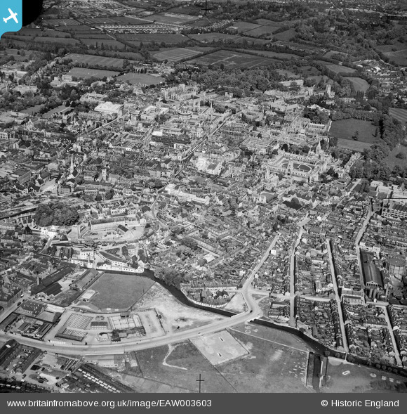
EAW003603 ENGLAND (1947). The city, Oxford, from the south-west, 1947
© Hawlfraint cyfranwyr OpenStreetMap a thrwyddedwyd gan yr OpenStreetMap Foundation. 2024. Trwyddedir y gartograffeg fel CC BY-SA.
Delweddau cyfagos (4)
EAW003603

EPW022525

EPW000841

EPW000835

Manylion
| Pennawd | [EAW003603] The city, Oxford, from the south-west, 1947 |
| Cyfeirnod | EAW003603 |
| Dyddiad | March-1947 |
| Dolen | |
| Enw lle | OXFORD |
| Plwyf | |
| Ardal | |
| Gwlad | ENGLAND |
| Dwyreiniad / Gogleddiad | 450914, 205920 |
| Hydred / Lledred | -1.262398632293, 51.749205105324 |
| Cyfeirnod Grid Cenedlaethol | SP509059 |
Pinnau
 Andy from Abingdon on Thames |
Friday 30th of September 2016 09:52:52 PM | |
Andy from Abingdon on Thames |
Friday 30th of September 2016 09:51:32 PM | |
Andy from Abingdon on Thames |
Saturday 4th of January 2014 09:39:28 PM | |
Andy from Abingdon on Thames |
Saturday 4th of January 2014 09:37:23 PM | |
Andy from Abingdon on Thames |
Saturday 4th of January 2014 09:31:27 PM | |
 Alan McFaden |
Saturday 4th of January 2014 07:06:28 PM | |
Alan McFaden |
Saturday 4th of January 2014 07:05:47 PM | |
jjrc |
Tuesday 31st of December 2013 04:28:54 PM | |
jjrc |
Tuesday 31st of December 2013 04:27:06 PM | |
jjrc |
Tuesday 31st of December 2013 04:24:57 PM | |
jjrc |
Tuesday 31st of December 2013 04:23:55 PM | |
jjrc |
Tuesday 31st of December 2013 04:22:14 PM | |
jjrc |
Tuesday 31st of December 2013 04:20:25 PM | |
jjrc |
Tuesday 31st of December 2013 04:19:57 PM | |
jjrc |
Tuesday 31st of December 2013 04:18:48 PM | |
Antony |
Friday 29th of November 2013 10:54:15 AM | |
Apart from the obvious..alien landing sites..the slab is almost in the same postion as current ice rink..if you compare the bridge position...https://www.google.com/maps/place/Oxford/@51.7486997,-1.2645442,140m/data=!3m1!1e3!4m2!3m1!1s0x48713380adc41faf:0xc820dba8cb547402 |
yokayo9121 |
Sunday 30th of March 2014 02:34:29 AM |
ndaisley |
Wednesday 4th of September 2013 10:50:11 PM | |
ndaisley |
Wednesday 4th of September 2013 10:41:04 PM | |
ndaisley |
Wednesday 4th of September 2013 10:37:10 PM | |
ndaisley |
Wednesday 4th of September 2013 10:30:47 PM | |
ndaisley |
Wednesday 4th of September 2013 10:06:59 PM | |
ndaisley |
Monday 2nd of September 2013 06:19:20 PM |