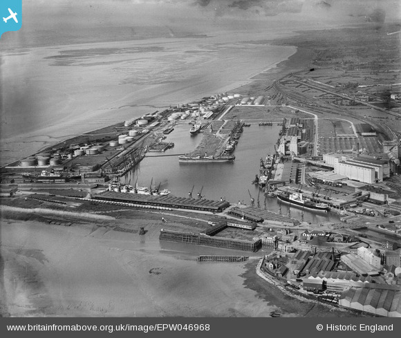
epw046968 ENGLAND (1935). The Royal Edward Dock and environs, Avonmouth, from the south, 1935
© Copyright OpenStreetMap contributors and licensed by the OpenStreetMap Foundation. 2024. Cartography is licensed as CC BY-SA.
Nearby Images (17)
Details
| Title | [EPW046968] The Royal Edward Dock and environs, Avonmouth, from the south, 1935 |
| Reference | EPW046968 |
| Date | May-1935 |
| Link | |
| Place name | AVONMOUTH |
| Parish | |
| District | |
| Country | ENGLAND |
| Easting / Northing | 350921, 178493 |
| Longitude / Latitude | -2.7071749484814, 51.502755635087 |
| National Grid Reference | ST509785 |
Pins
 MB |
Saturday 20th of August 2016 04:59:19 PM | |
 MB |
Saturday 20th of August 2016 04:58:38 PM | |
 MB |
Saturday 20th of August 2016 04:58:01 PM | |
 MB |
Saturday 20th of August 2016 04:57:37 PM | |
 MB |
Saturday 20th of August 2016 04:56:54 PM | |
 MB |
Saturday 20th of August 2016 04:56:27 PM | |
 MB |
Saturday 20th of August 2016 04:55:37 PM | |
 MB |
Saturday 20th of August 2016 04:55:20 PM |


![[EPW046968] The Royal Edward Dock and environs, Avonmouth, from the south, 1935](http://britainfromabove.org.uk/sites/all/libraries/aerofilms-images/public/100x100/EPW/046/EPW046968.jpg)
![[EPW005504] The Royal Edward Dock, Avonmouth, from the south-west, 1921](http://britainfromabove.org.uk/sites/all/libraries/aerofilms-images/public/100x100/EPW/005/EPW005504.jpg)
![[EAW002056] Avonmouth Docks, Avonmouth, 1946](http://britainfromabove.org.uk/sites/all/libraries/aerofilms-images/public/100x100/EAW/002/EAW002056.jpg)
![[EAW002061] Avonmouth Docks, Avonmouth, 1946. This image has been produced from a print.](http://britainfromabove.org.uk/sites/all/libraries/aerofilms-images/public/100x100/EAW/002/EAW002061.jpg)
![[EAW002073] Avonmouth Docks, Avonmouth, 1946. This image has been produced from a print.](http://britainfromabove.org.uk/sites/all/libraries/aerofilms-images/public/100x100/EAW/002/EAW002073.jpg)
![[EAW002062] Avonmouth Docks, Avonmouth, 1946. This image has been produced from a print.](http://britainfromabove.org.uk/sites/all/libraries/aerofilms-images/public/100x100/EAW/002/EAW002062.jpg)
![[EPW046969] The Royal Edward Dock and environs, Avonmouth, from the south, 1935](http://britainfromabove.org.uk/sites/all/libraries/aerofilms-images/public/100x100/EPW/046/EPW046969.jpg)
![[EAW002057] Avonmouth Docks, Avonmouth, 1946. This image has been produced from a print.](http://britainfromabove.org.uk/sites/all/libraries/aerofilms-images/public/100x100/EAW/002/EAW002057.jpg)
![[EAW002243] The Port of Bristol Authority Royal Edward Docks, Avonmouth, from the south, 1946. This image has been produced from a print.](http://britainfromabove.org.uk/sites/all/libraries/aerofilms-images/public/100x100/EAW/002/EAW002243.jpg)
![[EAW002070] Avonmouth Docks, Avonmouth, 1946](http://britainfromabove.org.uk/sites/all/libraries/aerofilms-images/public/100x100/EAW/002/EAW002070.jpg)
![[EPW027950] Avonmouth Docks, Avonmouth, 1929. This image has been produced from a print.](http://britainfromabove.org.uk/sites/all/libraries/aerofilms-images/public/100x100/EPW/027/EPW027950.jpg)
![[EPW005533] The Royal Edward Dock, Avonmouth, 1921. This image has been produced from a print.](http://britainfromabove.org.uk/sites/all/libraries/aerofilms-images/public/100x100/EPW/005/EPW005533.jpg)
![[EPW005518] No. 1 Granary and warehouses beside the Royal Edward Dock, Avonmouth, from the south-west, 1921](http://britainfromabove.org.uk/sites/all/libraries/aerofilms-images/public/100x100/EPW/005/EPW005518.jpg)
![[EPW005502] The Royal Edward Dock, Avonmouth, from the south-west, 1921](http://britainfromabove.org.uk/sites/all/libraries/aerofilms-images/public/100x100/EPW/005/EPW005502.jpg)
![[EPW022378] The Royal Edward Dock, Avonmouth, 1928](http://britainfromabove.org.uk/sites/all/libraries/aerofilms-images/public/100x100/EPW/022/EPW022378.jpg)
![[EPW005529] The Junction Cut and the village, Avonmouth, 1921](http://britainfromabove.org.uk/sites/all/libraries/aerofilms-images/public/100x100/EPW/005/EPW005529.jpg)
![[EPW005525] The Royal Edward Dock, Avonmouth, from the south-west, 1921](http://britainfromabove.org.uk/sites/all/libraries/aerofilms-images/public/100x100/EPW/005/EPW005525.jpg)