
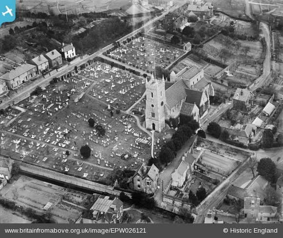
epw026121 ENGLAND (1929). St Leonard's Church and graveyard, Hythe, 1929
© Copyright OpenStreetMap contributors and licensed by the OpenStreetMap Foundation. 2024. Cartography is licensed as CC BY-SA.
Nearby Images (4)
EPW026121

EPW000158

EPW000132

EPW009221

Details
| Title | [EPW026121] St Leonard's Church and graveyard, Hythe, 1929 |
| Reference | EPW026121 |
| Date | April-1929 |
| Link | |
| Place name | HYTHE |
| Parish | HYTHE |
| District | |
| Country | ENGLAND |
| Easting / Northing | 616133, 134927 |
| Longitude / Latitude | 1.0855621722739, 51.07237373363 |
| National Grid Reference | TR161349 |
Pins
 Alan McFaden |
Wednesday 9th of July 2014 10:47:02 PM | |
Alan McFaden |
Wednesday 9th of July 2014 10:46:08 PM |


User Comment Contributions
The double pithed roof house in the fore ground was where I lived. We had move3d to Newhaven during the war, my father was a Sergeant in the Royal Artillery and posted to coastal radar stations. After the war we moved back to Hythe, our home town, and housed at Oak Walk in this house named Oak Dene. It was in quite a bad state and condemned before we even moved in. We kids loved it and during the summer we slept in the attic, it being too cold in the winters to sleep up there. We were eventually re-housed in a brand new house in Wakefield Way |
 John |
Monday 4th of November 2013 05:46:35 PM |