
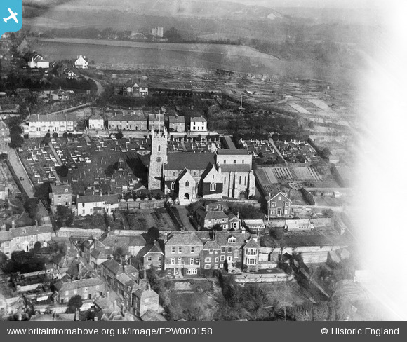
EPW000158 ENGLAND (1920). St Leonard's Church, Hythe, 1920
© Copyright OpenStreetMap contributors and licensed by the OpenStreetMap Foundation. 2025. Cartography is licensed as CC BY-SA.
Nearby Images (4)
EPW000158

EPW000132

EPW026121

EPW009221

Details
| Title | [EPW000158] St Leonard's Church, Hythe, 1920 |
| Reference | EPW000158 |
| Date | February-1920 |
| Link | |
| Place name | HYTHE |
| Parish | HYTHE |
| District | |
| Country | ENGLAND |
| Easting / Northing | 616152, 134912 |
| Longitude / Latitude | 1.0858240323116, 51.072231876555 |
| National Grid Reference | TR162349 |
Pins

Alan McFaden |
Wednesday 9th of July 2014 10:42:34 PM | |
|
Alan McFaden |
Wednesday 9th of July 2014 10:41:33 PM | |

Gone2Kent |
Wednesday 25th of December 2013 07:20:41 PM | |

Class31 |
Sunday 5th of August 2012 06:14:32 PM | |
|
Class31 |
Sunday 5th of August 2012 06:13:35 PM | |
|
Class31 |
Sunday 5th of August 2012 06:12:46 PM | |
|
Class31 |
Sunday 5th of August 2012 06:08:26 PM | |
|
Susannah |
Wednesday 27th of June 2012 02:31:41 PM | |
|
Susannah |
Wednesday 27th of June 2012 02:30:51 PM |


User Comment Contributions
Dear Shortcut Ben and Susannah, That’s great; we’ve reviewed your comments and thanks to your help we can update the catalogue. The revised record will appear here in due course. Hope you have the same success solving some of our other mysteries! Katy Whitaker Britain from Above Cataloguer |
Katy Whitaker |
Monday 2nd of July 2012 12:22:44 PM |
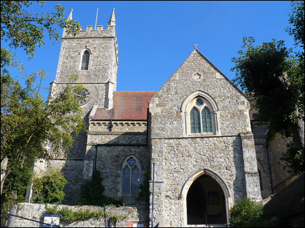
Picture of St Leonards. See that the tower and entrance in this picture are identical to Aerofilm image. :) |
Shortcut Ben |
Wednesday 27th of June 2012 10:39:16 AM |
This is a picture of St Leonards Church in Hythe. The coastal town was much smaller in 1920. Lionel Lukin, credited with inventing the self-righting lifeboat, is buried in the parish churchyard. The Vicarage/Oak Walk Hythe CT21 5DN, United Kingdom http://www.stleonardschurchhythekent.org/ http://goo.gl/maps/Mxhp |
Shortcut Ben |
Wednesday 27th of June 2012 10:32:44 AM |