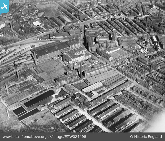
epw024498 ENGLAND (1928). Fieldhead Worsted Mills, City Roads Goods Station and nearby mills and dye works, Bradford, 1928
© Copyright OpenStreetMap contributors and licensed by the OpenStreetMap Foundation. 2024. Cartography is licensed as CC BY-SA.
Details
| Title | [EPW024498] Fieldhead Worsted Mills, City Roads Goods Station and nearby mills and dye works, Bradford, 1928 |
| Reference | EPW024498 |
| Date | September-1928 |
| Link | |
| Place name | BRADFORD |
| Parish | |
| District | |
| Country | ENGLAND |
| Easting / Northing | 415153, 433331 |
| Longitude / Latitude | -1.76993303398, 53.79585170682 |
| National Grid Reference | SE152333 |
Pins
 Paul McGowan |
Tuesday 9th of February 2016 12:27:50 PM | |
 hoppy |
Monday 15th of April 2013 07:06:30 AM | |
 hoppy |
Monday 15th of April 2013 07:03:31 AM | |
 hoppy |
Monday 15th of April 2013 07:02:43 AM | |
 hoppy |
Monday 15th of April 2013 07:01:57 AM |
User Comment Contributions
Fieldhead Mills were owned and operated by John Smith & Sons Limited, worsted spinners. The Bradford Beck runs through the mill site. This worsted spinning business was acquired by Illingworth Morris in the 1950s and the mill site was closed in the 1970s. |
 Barney Drake |
Tuesday 26th of June 2012 11:19:42 PM |


![[EPW024498] Fieldhead Worsted Mills, City Roads Goods Station and nearby mills and dye works, Bradford, 1928](http://britainfromabove.org.uk/sites/all/libraries/aerofilms-images/public/100x100/EPW/024/EPW024498.jpg)
![[EPW024500] Fieldhead Worsted Mills, City Roads Goods Station and nearby mills and dye works, Bradford, 1928. This image has been produced from a print.](http://britainfromabove.org.uk/sites/all/libraries/aerofilms-images/public/100x100/EPW/024/EPW024500.jpg)
![[EPW052160] City Road Goods Station and surrounding industrial buildings and residential streets, Bradford, 1936. This image has been produced from a print.](http://britainfromabove.org.uk/sites/all/libraries/aerofilms-images/public/100x100/EPW/052/EPW052160.jpg)
![[EPW051229] Lister Hills and environs, Bradford, 1936. This image has been produced from a print.](http://britainfromabove.org.uk/sites/all/libraries/aerofilms-images/public/100x100/EPW/051/EPW051229.jpg)