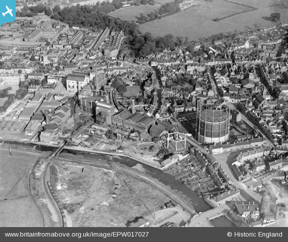
epw017027 ENGLAND (1926). The Stafford Corporation Gas Works, Stafford, 1926
© Copyright OpenStreetMap contributors and licensed by the OpenStreetMap Foundation. 2024. Cartography is licensed as CC BY-SA.
Nearby Images (19)
Details
| Title | [EPW017027] The Stafford Corporation Gas Works, Stafford, 1926 |
| Reference | EPW017027 |
| Date | October-1926 |
| Link | |
| Place name | STAFFORD |
| Parish | |
| District | |
| Country | ENGLAND |
| Easting / Northing | 391943, 323427 |
| Longitude / Latitude | -2.1195379352774, 52.808001488406 |
| National Grid Reference | SJ919234 |
Pins
 Yosser |
Monday 9th of September 2024 04:33:31 PM | |
 Class31 |
Tuesday 18th of August 2015 02:35:01 PM | |
 Class31 |
Tuesday 18th of August 2015 02:24:43 PM | |
 MB |
Friday 28th of September 2012 10:30:35 AM | |
 MB |
Friday 28th of September 2012 10:30:09 AM | |
 MB |
Friday 28th of September 2012 10:29:31 AM | |
 MB |
Friday 28th of September 2012 10:28:55 AM | |
 Class31 |
Thursday 23rd of August 2012 11:55:37 PM | |
 gardenersworld |
Sunday 8th of July 2012 12:36:58 PM | |
 stoke2010 |
Saturday 7th of July 2012 10:44:30 AM | |
 berryphil |
Tuesday 26th of June 2012 12:57:19 PM |
User Comment Contributions
The Vine Hotel, Stafford, 12/08/2015 |
 Class31 |
Tuesday 18th of August 2015 07:32:45 AM |


![[EPW017027] The Stafford Corporation Gas Works, Stafford, 1926](http://britainfromabove.org.uk/sites/all/libraries/aerofilms-images/public/100x100/EPW/017/EPW017027.jpg)
![[EAW024968] The Evode Ltd Polish and Adhesive Works, Stafford, 1949. This image was marked by Aerofilms Ltd for photo editing.](http://britainfromabove.org.uk/sites/all/libraries/aerofilms-images/public/100x100/EAW/024/EAW024968.jpg)
![[EAW024967] The Evode Ltd Polish and Adhesive Works and the town centre, Stafford, 1949](http://britainfromabove.org.uk/sites/all/libraries/aerofilms-images/public/100x100/EAW/024/EAW024967.jpg)
![[EAW024962] The Evode Ltd Polish and Adhesive Works (site of), Stafford, 1949. This image has been produced from a damaged negative.](http://britainfromabove.org.uk/sites/all/libraries/aerofilms-images/public/100x100/EAW/024/EAW024962.jpg)
![[EAW024961] The Evode Ltd Polish and Adhesive Works (site of), Stafford, 1949. This image has been produced from a damaged negative.](http://britainfromabove.org.uk/sites/all/libraries/aerofilms-images/public/100x100/EAW/024/EAW024961.jpg)
![[EAW024963] The Evode Ltd Polish and Adhesive Works and environs, Stafford, 1949. This image has been produced from a print marked by Aerofilms Ltd for photo editing.](http://britainfromabove.org.uk/sites/all/libraries/aerofilms-images/public/100x100/EAW/024/EAW024963.jpg)
![[EAW024964] The Evode Ltd Polish and Adhesive Works, Stafford, 1949. This image has been produced from a damaged negative.](http://britainfromabove.org.uk/sites/all/libraries/aerofilms-images/public/100x100/EAW/024/EAW024964.jpg)
![[EAW024965] The Evode Ltd Polish and Adhesive Works, Stafford, 1949. This image has been produced from a damaged negative.](http://britainfromabove.org.uk/sites/all/libraries/aerofilms-images/public/100x100/EAW/024/EAW024965.jpg)
![[EPW020050] The Town Centre, Stafford, 1927](http://britainfromabove.org.uk/sites/all/libraries/aerofilms-images/public/100x100/EPW/020/EPW020050.jpg)
![[EAW024966] HM Prison Stafford and the Evode Ltd Polish and Adhesive Works, Stafford, 1949. This image was marked by Aerofilms Ltd for photo editing.](http://britainfromabove.org.uk/sites/all/libraries/aerofilms-images/public/100x100/EAW/024/EAW024966.jpg)
![[EAW001867] Gaolgate Street, Stafford, 1946](http://britainfromabove.org.uk/sites/all/libraries/aerofilms-images/public/100x100/EAW/001/EAW001867.jpg)
![[EPW034022] Victoria Park and the town centre, Stafford, 1930](http://britainfromabove.org.uk/sites/all/libraries/aerofilms-images/public/100x100/EPW/034/EPW034022.jpg)
![[EPW053380] The Shire Hall, Gaolgate Street and the town centre, Stafford, 1937](http://britainfromabove.org.uk/sites/all/libraries/aerofilms-images/public/100x100/EPW/053/EPW053380.jpg)
![[EPW053381] St Mary's Church and the town centre, Stafford, 1937](http://britainfromabove.org.uk/sites/all/libraries/aerofilms-images/public/100x100/EPW/053/EPW053381.jpg)
![[EAW024969] The Evode Ltd Polish and Adhesive Works, the Staffordshire General Infirmary and environs, Stafford, 1949. This image was marked by Aerofilms Ltd for photo editing.](http://britainfromabove.org.uk/sites/all/libraries/aerofilms-images/public/100x100/EAW/024/EAW024969.jpg)
![[EPW020052] The Town Centre, Stafford, from the south-west, 1927](http://britainfromabove.org.uk/sites/all/libraries/aerofilms-images/public/100x100/EPW/020/EPW020052.jpg)
![[EAW001865] St Mary's Church, Greengate Street and the town centre, Stafford, 1946](http://britainfromabove.org.uk/sites/all/libraries/aerofilms-images/public/100x100/EAW/001/EAW001865.jpg)
![[EAW001866] St Mary's Church and the town centre, Stafford, 1946](http://britainfromabove.org.uk/sites/all/libraries/aerofilms-images/public/100x100/EAW/001/EAW001866.jpg)
![[EPW014109] The town centre, Stafford, 1925. This image has been produced from a copy-negative.](http://britainfromabove.org.uk/sites/all/libraries/aerofilms-images/public/100x100/EPW/014/EPW014109.jpg)