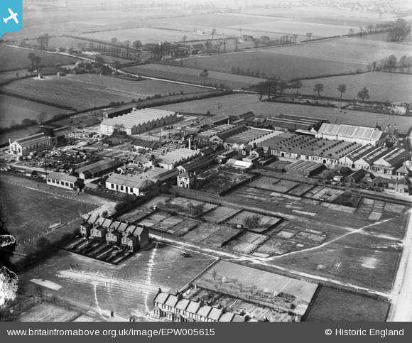
epw005615 ENGLAND (1921). The Sterling Works, Dagenham, 1921
© Copyright OpenStreetMap contributors and licensed by the OpenStreetMap Foundation. 2024. Cartography is licensed as CC BY-SA.
Nearby Images (22)
Details
| Title | [EPW005615] The Sterling Works, Dagenham, 1921 |
| Reference | EPW005615 |
| Date | March-1921 |
| Link | |
| Place name | DAGENHAM |
| Parish | |
| District | |
| Country | ENGLAND |
| Easting / Northing | 549889, 185560 |
| Longitude / Latitude | 0.16200687566215, 51.548517432368 |
| National Grid Reference | TQ499856 |
Pins
Be the first to add a comment to this image!


![[EPW005615] The Sterling Works, Dagenham, 1921](http://britainfromabove.org.uk/sites/all/libraries/aerofilms-images/public/100x100/EPW/005/EPW005615.jpg)
![[EPW008520] The Sterling Works, Dagenham, 1923](http://britainfromabove.org.uk/sites/all/libraries/aerofilms-images/public/100x100/EPW/008/EPW008520.jpg)
![[EPW005610] The Sterling Works, Dagenham, 1921](http://britainfromabove.org.uk/sites/all/libraries/aerofilms-images/public/100x100/EPW/005/EPW005610.jpg)
![[EPW008527] The Sterling Works, Dagenham, 1923](http://britainfromabove.org.uk/sites/all/libraries/aerofilms-images/public/100x100/EPW/008/EPW008527.jpg)
![[EPW008524] The Sterling Works, Dagenham, 1923](http://britainfromabove.org.uk/sites/all/libraries/aerofilms-images/public/100x100/EPW/008/EPW008524.jpg)
![[EPW008523A] The Sterling Works, Dagenham, 1923](http://britainfromabove.org.uk/sites/all/libraries/aerofilms-images/public/100x100/EPW/008/EPW008523A.jpg)
![[EPW008528] The Sterling Works, Dagenham, 1923](http://britainfromabove.org.uk/sites/all/libraries/aerofilms-images/public/100x100/EPW/008/EPW008528.jpg)
![[EPW005612] The Sterling Works, Dagenham, from the south, 1921](http://britainfromabove.org.uk/sites/all/libraries/aerofilms-images/public/100x100/EPW/005/EPW005612.jpg)
![[EPW005613] The Sterling Works, Dagenham, 1921](http://britainfromabove.org.uk/sites/all/libraries/aerofilms-images/public/100x100/EPW/005/EPW005613.jpg)
![[EAW040652] The Ford Motor Co Rainham Works, Dagenham, 1951. This image has been produced from a print marked by Aerofilms Ltd for photo editing.](http://britainfromabove.org.uk/sites/all/libraries/aerofilms-images/public/100x100/EAW/040/EAW040652.jpg)
![[EAW040649] The Ford Motor Co Rainham Works, Dagenham, 1951. This image has been produced from a print marked by Aerofilms Ltd for photo editing.](http://britainfromabove.org.uk/sites/all/libraries/aerofilms-images/public/100x100/EAW/040/EAW040649.jpg)
![[EAW040650] The Ford Motor Co Rainham Works, Dagenham, 1951. This image has been produced from a print marked by Aerofilms Ltd for photo editing.](http://britainfromabove.org.uk/sites/all/libraries/aerofilms-images/public/100x100/EAW/040/EAW040650.jpg)
![[EPW008521] The Sterling Works, Dagenham, 1923](http://britainfromabove.org.uk/sites/all/libraries/aerofilms-images/public/100x100/EPW/008/EPW008521.jpg)
![[EPW008523] The Sterling Works, Dagenham, 1923](http://britainfromabove.org.uk/sites/all/libraries/aerofilms-images/public/100x100/EPW/008/EPW008523.jpg)
![[EPW005611] The Sterling Works, Dagenham, from the south-west, 1921](http://britainfromabove.org.uk/sites/all/libraries/aerofilms-images/public/100x100/EPW/005/EPW005611.jpg)
![[EPW008522] The Sterling Works, Dagenham, 1923](http://britainfromabove.org.uk/sites/all/libraries/aerofilms-images/public/100x100/EPW/008/EPW008522.jpg)
![[EPW056253] Ismay Cables Ltd, Dagenham, 1938](http://britainfromabove.org.uk/sites/all/libraries/aerofilms-images/public/100x100/EPW/056/EPW056253.jpg)
![[EPW056255] Ismay Cables Ltd, Dagenham, 1938](http://britainfromabove.org.uk/sites/all/libraries/aerofilms-images/public/100x100/EPW/056/EPW056255.jpg)
![[EPW056252] Ismay Cables Ltd, Dagenham, 1938](http://britainfromabove.org.uk/sites/all/libraries/aerofilms-images/public/100x100/EPW/056/EPW056252.jpg)
![[EPW056254] Ismay Cables Ltd, Dagenham, 1938](http://britainfromabove.org.uk/sites/all/libraries/aerofilms-images/public/100x100/EPW/056/EPW056254.jpg)
![[EPW056251] Ismay Cables Ltd, Dagenham, 1938](http://britainfromabove.org.uk/sites/all/libraries/aerofilms-images/public/100x100/EPW/056/EPW056251.jpg)
![[EPW056256] Ismay Cables Ltd and environs, Dagenham, 1938](http://britainfromabove.org.uk/sites/all/libraries/aerofilms-images/public/100x100/EPW/056/EPW056256.jpg)


