
Scheduled Maintenance
This website will undergo scheduled maintenance on Tuesday, September 10th, between 11:00 and 15:00, as well as on Thursday, September 12th, between 10:00 and 12:00. During this time, services may be temporarily disrupted. We apologise for any inconvenience.
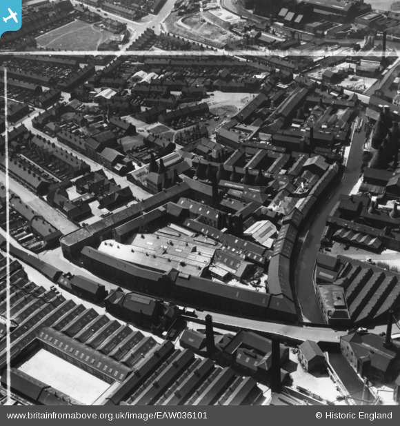
eaw036101 ENGLAND (1951). The Imperial Pottery (Earthenware) and environs, Hanley, 1951. This image has been produced from a print marked by Aerofilms Ltd for photo editing.
© Copyright OpenStreetMap contributors and licensed by the OpenStreetMap Foundation. 2024. Cartography is licensed as CC BY-SA.
Nearby Images (14)
EAW036101
 and environs, Hanley, 1951. This image has been produced from a print marked by Aerofilms Ltd for photo editing.")
EAW036102
 and environs, Hanley, 1951. This image has been produced from a print marked by Aerofilms Ltd for photo editing.")
EAW036095
 and environs, Hanley, 1951. This image has been produced from a print marked by Aerofilms Ltd for photo editing.")
EAW036097
 and environs, Hanley, 1951. This image has been produced from a print marked by Aerofilms Ltd for photo editing.")
EAW036098
 and environs, Hanley, 1951. This image has been produced from a print marked by Aerofilms Ltd for photo editing.")
EAW036096
 and environs, Hanley, 1951. This image has been produced from a print marked by Aerofilms Ltd for photo editing.")
EAW036099
 and environs, Hanley, 1951. This image has been produced from a print marked by Aerofilms Ltd for photo editing.")
EAW036100
 and environs, Hanley, 1951. This image has been produced from a print marked by Aerofilms Ltd for photo editing.")
EPW053358
, Hanley, 1937")
EPW036110

EAW036104
 and environs, Hanley, 1951. This image has been produced from a print marked by Aerofilms Ltd for photo editing.")
EAW036103
 and environs, Hanley, 1951. This image has been produced from a print marked by Aerofilms Ltd for photo editing.")
EPW042665
, Hanley, 1933")
EPW042666
, Hanley, 1933")
Details
| Title | [EAW036101] The Imperial Pottery (Earthenware) and environs, Hanley, 1951. This image has been produced from a print marked by Aerofilms Ltd for photo editing. |
| Reference | EAW036101 |
| Date | 18-May-1951 |
| Link | |
| Place name | HANLEY |
| Parish | |
| District | |
| Country | ENGLAND |
| Easting / Northing | 388799, 346891 |
| Longitude / Latitude | -2.1669932053197, 53.018893996125 |
| National Grid Reference | SJ888469 |
Pins
Be the first to add a comment to this image!